Top 10 summits are the pinnacle of outdoor adventure in Appalachia.
Shenandoah Mountain, Virginia
Is there any Virginia mountain more famous than Shenandoah? This 73-mile long ridge helps form the border between West Virginia and Virgina while also defining the western end of the Shenandoah Valley. And all of it sits inside the George Washington National Forest, offering some of the most varied recreation in the state. Shenandoah boasts five roadless areas, one federally designated Wilderness, more epic mountain bike trails than you could ride in a lifetime, and even some decent climbing.

Bike it
Southern Traverse in the Deerfield Ranger District was designated an IMBA Epic Trail system in 2000. The 17-mile stretch of the Shenandoah Mountain Trail, which is some of the finest ridgeline singletrack in the East, is worth the hype. Road riders and mountain bikers alike also love and loathe the relentless climb up Reddish Knob, the highest peak on Shenandoah Mountain at 4,381 feet.
Backpack it
Wild Oak National Recreation Trail: This 25.6-mile loop cruises through the Little River Roadless Area and Ramsey’s Draft Wilderness, sticking predominantly to the 3,000- and 4,000-foot ridgelines that define Shenandoah Mountain. Camp on Little Bald Knob and enjoy the views from Grindstone Mountain and Big Bald Knob.
Hike it
Ramsey’s Draft Trail: It’s popular, but this 6.8-mile path follows the creek of the same name through the heart of the 6,518-acre Wilderness area on the eastern flank of Shenandoah Mountain. If you want a less crowded path through the Wilderness, check out the Bald Ridge Trail, an 8.3-mile hike along the ridgeline of the eastern side of the Wilderness.
Race it
Shenandoah Mountain 100: Arguably the most respected endurance mountain bike race in the South, the SM100 attracts the best pros from around the country as well as the most avid weekend warriors. The course features 12,000 feet of climbing mostly on forest roads and some of the most choice downhills in the forest.
Grindstone 100: This beastly 100-mile foot race takes runners up and over Little North Mountain and Great North Mountain before tackling Reddish Knob, the highest peak on Shenandoah Mountain.
eco-xsports.com
Camp it
You’ve got a variety of options for developed camping on and around Shenandoah Mountain. Try Todd Lake Recreation Area, with sites surrounding a 7.5-acre lake, or the North River Campground, which is an old Civilian Conservation Corps camp.

Spruce Mountain, West Virginia
In a state known for its mountains, Spruce Mountain rises above the rest…literally. Spruce runs for 16 miles inside Pendleton County, with several peaks topping 4,500 feet, including West Virginia’s highest peak, Spruce Knob (4,861 feet). Recreation reigns supreme on Spruce, which is home to 75 miles of trail and some of the best backcountry hiking and mountain biking in the Mountain State. Much of the mountain is part of the Spruce Knob-Seneca Rocks National Recreation Area. The western flank of the mountain is dominated by the Seneca Creek Backcountry, a 24,000-acre roadless area that was originally part of the Wild Monongahela Wilderness Bill (but was cut from the final bill before it passed in 2009).
Backpack it
Spruce Loop: This 13-mile loop traversing the western flank of Spruce takes in high elevation meadows, waterfalls, and creek crossings. Hike Lumberjack Trail (534) for 5.7 miles on an old railroad grade through muddy bogs, to High Meadows Trail, which passes through four different meadows with views of Seneca Creek Valley and the Allegheny Mountains. Huckleberry Trail drops from the ridgeline to the valley floor in under half a mile, meeting Seneca Creek Trail near Upper Seneca Falls, a 30-foot drop with great campsites nearby. Take Seneca Creek Trail south for 5.2 miles of creek crossings and small waterfalls and trout fishing back to FR 112, less than a half-mile walk to your car.
Bike it
Spruce Knob Challenge: The Spruce Knob Challenge is an open challenge to Mountain State Wheelers to see who can tackle the 12-mile road climb to the top of the Knob the fastest. The route launches from State Road 33 in the valley, combining Briery Gap Road with the newly paved forest roads 112 and 104, climbing 2,500 feet to the summit. The route averages a 4.7 percent grade, but the climbing is relentless from the start of forest road 112.
Climb it
Seneca Rocks gets all the attention from climbers, and deservedly so, but if you’re looking for a quick pump with the prettiest backdrop in the Mountain State, the boulders at the top of Spruce Knob are the ticket. Most of the problems are on squarish, low ball boulders with juggy holds that require a sit start. Great for beginner climbers.
Hike it
Whispering Spruce Trail: The half-mile crushed-gravel path encircles Spruce Knob, taking hikers through spruce groves and boulder fields offering some of the best views in the state.
Race it
West Virginia Trilogy: New for 2010, this is a three-day stage race taking runners up and over the Eastern Continental Divide again and again. Most of the course is within the Spruce Knob-Seneca Rocks National Recreation Area. First day is 50K, second day is 50 miles, and the third is an easy 13.1 miles. Oct. 8-10, 2010. wvmtr.org
Camp it
On the western side of the mountain, the picturesque Spruce Knob Lake Campground has sites surrounding the 25-acre lake. It’s the highest lake and highest campground in the state, and gets you closest to the action on Spruce.

Blood Mountain, Georgia
The name alone is enough to set this peak apart from other mountains in North Georgia, but Blood also has the distinction of being the highest mountain on the Georgia portion of the Appalachian Trail (4,458 feet), and it’s the first Wilderness area that northbound thru-hikers encounter on their long walk to Maine. For many A.T. thru hikers, Blood is when reality sets in. For the rest of us, it’s a recreation hot spot that combines state park convenience (Vogel State Park sits at the base of Blood) with Wilderness isolation.
And what about that name? Some say it derives from the color of the red lichen and Catawba rhododendron that mark the summit; others insist the mountain was named for the brutal battle between the Cherokee and Creek Indians that took place on the mountain.
Hike it
Appalachian Trail: Starting at Neel’s Gap, take the Byron Herbert Reece Access Trail to the A.T. for a short but steep two-mile climb to the summit of Blood Mountain. The seven-mile Blood Mountain Loop also begins with the Reece Access Trail at Neel’s Gap, but takes you on the rocky Freeman Trail, which skirts the southern face of Blood Mountain traveling through the heart of the Wilderness before connecting with the A.T. at Byrd Gap and Flat Rock Gap on either side of Blood’s summit.
Backpack it
Coosa Backcountry Trail: The Coosa starts in Vogel State Park (get a permit) but quickly enters the Blood Mountain Wilderness on a 16-mile loop over classic gap-to-summit terrain. You’ll cross Coosa Bald (now reforested with hardwoods), hit good views from Slaughter Mountain and Ben’s Knob, and find good camping near Wolf Gap.
Climb it
Blood Mountain doesn’t receive a lot of attention from climbers, but sendable boulders are scattered throughout the Wilderness area. You’ll pass some gems on the A.T. approach. But the most popular are located on the summit, with climbs beginning at the entrance of the Blood Mountain Shelter.
Swim it
At Blood Mountain Falls the stream cruises over a 20-foot rock slide with a decent pool at the bottom. The water is frigid, but it’s less crowded than nearby DeSoto Falls.
Camp it
Vogel State Park has a number of campsites, as well as cottages surrounding Lake Trahlyta, that make for a convenient base camp for exploring Blood Mountain. The Blood Mountain Shelter can be crowded on weekends, but primitive sites can be found throughout the summit area. On warm nights, hikers have been known to pitch their sleeping pads on top of the massive boulders near the shelter.

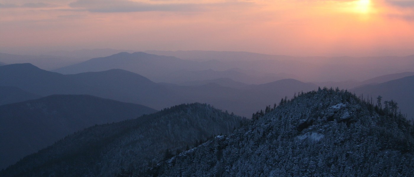
Mount Mitchell, North Carolina
Mount Mitchell is a mountain that demands superlatives. Tallest peak east of the Rockies, most commanding views in the Southern Appalachians, some of the toughest summit approaches in the South…the list goes on, as is befitting of the 6,684-foot monster. Thanks to the state park amenities and paved road to the top, plenty of people have soaked up the views from Mitchell’s lookout tower. But to truly appreciate the mountain, you have to explore its outer reaches. You have to pitch a tent on its flanks, pedal your bike up its switchbacking roads, and boot up its steep, steep terrain.
Bike it
Tackle the last 30 miles of the Assault on Mount Mitchell route for 8,000 feet of cumulative climbing, and the best views you can ride skinny tires to. The slog up Route 80 is the steepest portion, with tight switchbacks and a 10 percent grade. Once you reach the 11-mile Parkway segment, the jaw-dropping vistas ease the burn a little. For mountain bikes, follow the Old Toll Road, an 11-mile doubletrack path from the campus of Montreat College to the Blue Ridge Parkway. The tread alternates between sand, rocks, and bigger rocks in a relentless granny gear climb to 6,000 feet above sea level.
Hike it
Mount Mitchell Trail: Yes, you can drive to the top of Mount Mitchell, but for purists, the only way to summit the tallest peak in the East is from the bottom up via the Mount Mitchell Trail. The path gains 3,600 feet from the Toe River Valley to the summit in 5.5 miles.
Backpack it
Mitchell Loop: Soak in the best views that Mount Mitchell has to offer on this 11-mile loop over rugged terrain. Pick up the Buncombe Horse Range Trail near the junction of 128 and the Blue Ridge Parkway and hike north for four miles to Commissary Hill, where you’ll set up camp on the edge of Mount Mitchell with commanding views to the east. Take the 1.5-mile side trip up Mount Mitchell Trail to take in the sunset from the observation tower. On day two, continue heading north on the Buncombe Horse Range Trail, using Big Tom Gap trail to connect with the Black Mountain Crest Trail, which you will take south back to Mount Mitchell. Rock-hop your way along the highest mountain range in the east, enjoying one expansive view after the other.
Race it
Mount Mitchell Challenge: Are you up for a 40-mile trail run up Mount Mitchell and then back down in the dead of winter? If so, this is the race for you. There was so much snowpack on the mountain in 2010, race directors had to reroute the race to accommodate.
Assault on Mount Mitchell: One of the most famous bike races in the country. For 35 years, bikers have been clamoring to earn a spot on this 104-mile ride from Spartanburg to the top of Mount Mitchell.
Off Road Assault on Mount Mitchell: This 64-mile ride from Old Fort climbs and descends the flanks of the tallest mountain in the east, gaining 11,000 cumulative feet.
Camp it
The park operates a family-friendly campground with all the expected amenities on site and Commissary Ridge offers short-access backcountry camping.
Walden Ridge, Tennessee
This massive mountain runs for 74 miles from Chattanooga, Tenn., north to Rockwood, Tenn., near Knoxville. Walden forms the eastern flank of the Cumberland Plateau, rising 1,000 feet from the floor of the Tennessee Valley to form the imposing Cumberland Escarpment. Along that escarpment is some of the best outdoor recreation in the Volunteer State, from epic climbing crags to a long trail in the making.
Paddle it
The eastern flank of Walden Ridge averages one creek every 2.5 miles. North Chickamauga Creek is 12 miles of class III-V creek boating through a wild gorge only 20 minutes north of Chattanooga, with five significant drops punctuated by Bowling Alley, a class III boulder garden that gets a lot of park-and-play attention.
Swim it
The 1,000-foot vertical drop and copious creeks along Walden Ridge mean one thing: waterfalls. Ozone Falls plunges 110 feet over a sandstone cliff, dumping into a pristine pool before disappearing underground for several feet. The entire scene is set inside a natural stone amphitheater. Upper Piney Falls drops 80 vertical feet inside a stone basin. The swimming at the bottom is picturesque, but you’ll have to bushwack down a steep slope to get to the pool at the base of the falls. Laurel Falls is another 80-foot plunge falls set inside a stone amphitheater. The 1.5-mile hike up Richland Creek to the falls is an adventure all on its own.
Backpack it
The Cumberland Trail traverses the eastern side of Walden as it moves north on its 300-mile journey from the Chickamauga National Military Park outside of Chattanooga to Cumberland Gap National Park in Kentucky. The entire trail hasn’t been completed yet (dedicated trail crews have finished about half of it) but some of the best completed sections are located on Walden Ridge. The Three Gorges section offers 31 miles of pristine trail, rocky ridgetop views, and cold-water swimming holes. If 31 miles is too stout, six trailheads are scattered throughout this section, enabling you to create shorter point-to-point hikes.
Bike it
Chattanooga’s mountain bikers are rediscovering the 24,000-acre Prentice Cooper State Forest on the southern end of Walden’s Ridge just outside of town. Bikes aren’t allowed on the singletrack within the forest, but the fire roads and ATV trails are open to fat tires.
Climb it
Tennessee Wall: The T-Wall is one of the most beloved crags in the south. Rising from the Tennessee Valley Floor, there are hundreds of hard sandstone trad routes to choose from with easy access. Check out the classics: Golden Locks (5.8), an intense but doable crack; and Art (5.8) a route along a dihedral with great exposure.
Camp it
Take your pick of primitive sites along the Cumberland Trail. For developed campgrounds, check out the Bowater Newby Branch Campground near Spring City on the north side of Walden Ridge, and Prentice Cooper State Forest on the south side of the ridge. •
Other Notable Mountains in the Blue Ridge
Crowders Mountain, N.C.
This peak may only be 1,625 feet, but it towers over its surrounding landscape, rising 800 feet from the valley floor, and offering Charlotte residents a mountain escape just west of town. The one-mile Backside Trail leads to Crowders Summit with 25-mile long views. The Ridgeline Trail travels 8.7-miles south into South Carolina, following the ridgeline of Kings Pinnacle along the way. In S.C., it meets the Kings Mountain National Recreation Trail, which cruises through the relatively high ridgeline of Kings Mountain National Military Park for 16 miles.
South Mountain, Md.
South Mountain tops out at a modest 1,850 feet, but it runs for 40 miles from north to south across Western Maryland, providing a range of recreation opportunities. The A.T. runs along the length of the ridge, which is highlighted by exposed quartzite cliffs. If you want to hit the highlights, head straight to High Rocks, a steep climb with the best views on the ridge. South offers a handful of different climbing crags, but the most popular is Annapolis Rock. A two-mile approach leads you to dozens of sport and trad routes on tough quartzite. Try Black Crack (5.9), a steep crack with good exposure.
Table Rock Mountain, S.C.
The 3,157-foot Table Rock Mountain sticks out along South Carolina’s Blue Ridge Escarpment thanks to its gray granite dome with a 350-foot rock face. Climb the Table Rock National Recreation Trail, which gains 2,000 feet in 3.6 miles on its way to the top of the rock dome.
Kennesaw Mountain, Ga.
The 1,808-foot Kennesaw Mountain serves as the centerpiece of the 2,884-acre Kennesaw Mountain National Battlefield, with over 16 miles of popular running and hiking trails. Kennesaw is the highest point in the metro Atlanta area, and from the summit, you can see downtown Atlanta 25 miles away. The quickest way to the summit is the Mountaintop Trail, which climbs steeply (averages 100 feet per .1 mile) from the visitor’s center to the observation platform.


