When it comes to its rivers, the Blue Ridge Mountains are a special place. Some of its flowing waters are among the oldest in the entire world; they have patiently been eating away at the bedrock for eons. These rivers have also long served as a draw for settlers and visitors alike who continue to seek out the ample opportunities to fish and float among the rapids and eddies. Our rivers also offer some of the best whitewater paddling you can find anywhere—which explains why we see so many kayaks tied to the roofs of cars around our region.
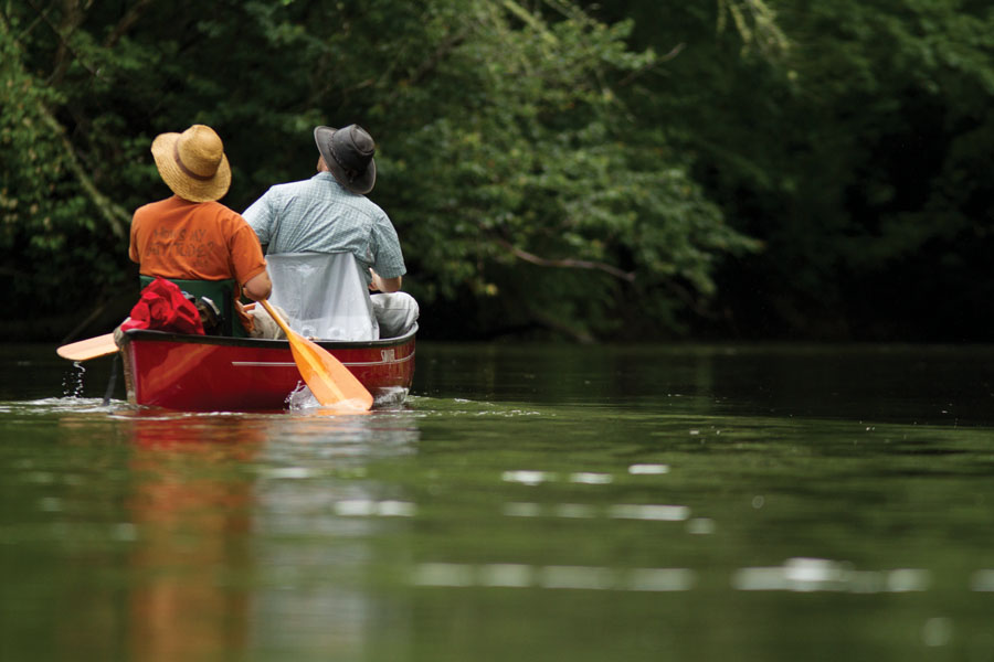
But the rivers here also deliver unique paddling opportunities to the less thrill-seeking among us. If a one- or two-day family-friendly float with the chance to stop along the way, pitch a tent, and spark a campfire sounds appealing to you, then read on. We have enlisted the help of three passionate advocates for our mountain rivers—Hartwell Carson, Mark Singleton, and Erin McCombs—who were willing to share some off-the-beaten-path stretches of river in the heart of the mountains that are not only easy to paddle and navigate, but also offer the chance to commune with an incredibly diverse range of aquatic wildlife. Depending on the season, you might even spy far more fish, fowl, and reptiles than you will other people. Well, as long as you don’t tell too many other folks about where you were.
The French Broad River
Carson Suggests:
Oskar Blues Brewery /Pisgah Forest Access to Penrose Access Area
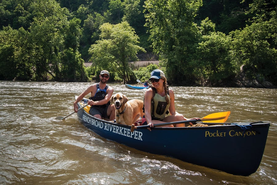
If you happen to spot Hartwell Carson out on the French Broad River, it’s likely his trusted yellow lab mix Junebug is riding shotgun. Whether it’s monitoring the river for sources of pollution like a leaky sewage pipe or picking up trash, Carson spends at least a few days every week floating and paddling the river in his job as the French Broad’s Riverkeeper, which is part of the Waterkeeper Alliance, a national organization based in New York City dedicated to keeping our rivers, lakes, and stream clean. For ten years, Carson has been patrolling the 213-mile river from its headwaters in Pisgah National Forest to its confluence with the Tennessee River in Knoxville, Tenn.
Today, Carson is part of MountainTrue, an environmental advocacy group based in Asheville, which continues to play a role in the rebirth of the French Broad as a destination for not just kayakers and tubers out for a lazy afternoon, but also the return of native wildlife like the muskellunge, better known as Muskie.
Carson moved to Asheville from Montana after earning a master’s degree in resource management and was immediately drawn to the wide river that cut through town. “Nobody would get into the river 10 or 11 years ago,” says Carson, who grew up in Georgia and visited Asheville in the summers. “But I’d like to credit our work for some of the cleaning up that we’ve seen in recent years.”
Carson has also paddled the entire river, including one epic adventure where he and a friend floated the entire 213 miles, a trip that took 16 days and involved eating a lot of bologna. The section of the river that runs through Asheville has become particularly popular with locals and tourists alike as the growing number of outfitters has made it easy and convenient to float or paddle up through the city’s burgeoning River Arts District and up to the Bywater, a much frequented drinking establishment in the summer months. Traffic on the river should surge even more when New Belgium Brewing, which hugs the river, opens in 2015. There’s even momentum to build a whitewater park in the same area.
For paddlers looking for a more serene experience on the river, Carson suggests heading south toward the river’s headwaters in Rosman, N.C. Unlike the Asheville section, which tends to be wide and relatively shallow, the upstream sections of the French Broad are more meandering and narrow, Carson says, with plenty of river birch and overhanging foliage to make it feel almost like you’re traveling through a tunnel at times.
A great stretch Carson recommends for some stress-free flat-water paddling begins near the Oskar Blues Brewery in Brevard at the Pisgah Forest Access area on Wilson Rd., which has ample parking and a concrete ramp to help launch watercraft. You then paddle north as you snake past some farms and pasture land until the Davidson River joins the French Broad, which picks up some steam with the addition of all that fast-moving mountain water.
This part of the river is also known as the “muskie mile” in honor of the giant prehistoric fish that lurk beneath the surface. The fish, which can reach three-feet-long and weigh more than 20 pounds each, now thrive in the river thanks to a fishery, the southernmost one dedicated to muskie in the U.S., which has helped rebuild the population of the species after it was wiped out by a chemical spill back in the 1940s. Though he’s tried countless times, Carson says he has yet to catch an elusive muskie. “They call them the fish of ten thousand casts,” he says.
After paddling for another five miles or so you’ll float by the Little River Campsite, a primitive paddle-in-only site that kicks off the French Broad Paddle Trail, which is a series of six campsites along the river that Carson helped establish. Would-be paddle-campers can visit the site frenchbroadpaddle.com to make reservations and extend their river adventures into multi-day affairs.
But if you’re interested in making more of a day trip of things, keep paddling for another mile or so until you reach the Penrose Access Area, a fairly new addition for the river that has a boat ramp, floating dock and plenty of space to keep the car you dropped off earlier that day.
The Little Tennessee
Singleton Suggests:
Needmore Rd to U.S. 19., at Fontana Lake
As you’re entering the town of Franklin, NC, it can be easy to miss that you’ve crossed the Little Tennessee River, or “Little T” as locals know it. While there’s a fine greenway that stretches north along the river’s banks for a few miles, the river itself flows unimpeded for some 24 miles from town until eventually being swallowed by the waters of Fontana Lake, which is created by the Fontana Dam.
Just a few miles north and downstream of town, the river enters some relatively remote and unpopulated territory that makes for some scintillating flat-water paddling on some of the cleanest and clearest water in the region. “This is a fun class II section, especially with kids,” says Mark Singleton, the director of American Whitewater, a non-profit dedicated to conserving and restoring America’s whitewater resources.
Singleton lives in nearby Cullowhee where his wife is a teacher at Western Carolina University. He moved to the area back in the 1990s to work for the Nantahala Outdoor Center before eventually taking over the director’s role at American Whitewater, where he’s been for the past 10 years. Singleton says he has long been a conservationist and has worked to support recreational access to other nearby rivers like the Tuckasegee, Nantahala, and Cheoah.
Singleton admits he prefers kayaking steeper whitewater or local Class III rapids. But when he’s up for something slower, he and his family truck over to the Little T for some relaxed summer floating.
One advantage the Little T has over some of its neighbors like the Nantahala, Singleton says, is that it’s both less crowded and warmer. When you combine those factors with how clear the water is, it makes for prime snorkeling opportunities. While that might at first seem counterintuitive—You can snorkel in a river?—the Little T offers Caribbean-like opportunities to spot multi-colored fish (especially during spawning season) of a startling variety such as largemouth bass, rock bass, perch, walleye, red-horse sucker, bream, bluegill, catfish, as well as many species of minnow. If you’re patient, you may even spy a giant salamander called a hellbender, which can grow up to 2.5 feet long. All that wildlife helps explain why the Little T will soon be designated a Native Fish Conservation Area. You might even see Native American fish weirs along the river as you paddle.
While you could float the entire 24-mile stretch from Franklin to Fontana Lake, Singleton recommends the six-mile section that begins along Needmore Road, about 13 miles north of Franklin, as a great day trip.
Drive up Rt. 28, Bryson City Rd., and then turn left over the bridge on Tellico Road to the gravel section of Needmore Rd. along the river, where you’ll find a series of excellent put ins as you travel downstream.
One feature to look for is the suspension bridge that spans the river, which was originally built to allow farm kids to catch the school bus in the days before quality roads existed on both sides of the river.
Your paddling adventure continues until you reach the take out at the bridge under U.S. 19, which involves a bit of a rocky climb to get from the river to your dropped car. You could also continue on into the lake itself.
Along the way you will see plenty of wildlife, forest, and farmland, but very few homes. There are also ample camping and picnicking opportunities along both banks of the river—as well as on several of the islands that have dug themselves in midstream.
One drawback of the Little T is that it can get shallow, especially during the summer when there hasn’t been a lot of rain. Singleton suggests checking out the U.S. Geological Survey gauges available online before heading to the river and waiting for a measurement of at least 1,000 cfs to ensure enough clearance over the river’s pebbly bottom.
The only hazard on the river is a set of potentially nasty rapids that sit midstream right before you reach the takeout. But, if you’ve picked a day where the water is running high enough, “you might not even know you’ve run them,” Singleton says.
The New River
McCombs Suggests:
New River State Park in North Carolina to Rte. 93 on the Virginia State Line
Did you know that some of the oldest rivers in the entire world are right here in the Appalachians? The most ancient of them all just might be the New River, which geologists believe could have begun flowing some 360 million years ago. The New gets it start by meandering through the town of Boone, N.C. as it continues flowing some 320 miles north into Virginia and West Virginia, where, near the town of Fayetteville, it spills over into the New River Gorge. Every summer, thousands of eager rafters and kayakers flock to the Gorge to tackle its series of challenging Class III and V rapids.
But the New River offers more than just whitewater thrills, says Erin McCombs, the associate conservation director for American Rivers, a Washington, D.C.-based organization dedicated to protecting and restoring our nation’s rivers. In particular, McCombs focuses on the potential for dam removal projects in the Southern Appalachian region.
McCombs, who grew up near the Mississippi River in Memphis, Tenn., studied biology at Appalachian State University in Boone where she first fell in love with our region’s wide-ranging biodiversity. “I continue to be in awe of the different species and habitats we have here,” she says. While she had dreamed of becoming a marine biologist growing up, McCombs increasingly became fascinated by the life teeming in the region’s multitude of rivers. As part of her master’s degree, she studied under Dr. Michael Gangloff, a malacologist, or expert on mollusks, who has been tracking the progress of how freshwater mussels on the New River are making a comeback. “Freshwater mussels are like environmental sentinels,” says McCombs. “Since they are filter feeders and need clean water free of pollution like sediment, freshwater mussels are a good indicator of the quality of the stream.”
A wide variety of fish now thrive in the cleaner waters of the river, including smallmouth bass—known as black bass—as well as muskie, flathead catfish, and even walleye. The New River is also home to plenty of wildlife that live above the waterline as well, including a wide variety of songbirds, wood ducks, kingfishers, and red-winged blackbirds.
A great place to start a journey on the river, says McCombs, is at the New River State Park, which is about an hour or so north of Boone near the town of Jefferson. The park is a beautiful wedge of land bordering the river that could be a camping, hiking, and picnicking destination all on its own. You can also pick up helpful maps and tips at the park’s ranger station to help you plan your journey. Put your boat in at the ramp at Wagoner Access point where the water gets lit up by the dappled sunlight that sneaks through the abundant trees and foliage bordering the river.
The river runs unimpeded from the park all the way up to the Virginia border, a stretch of some 27 miles that was designated a National Scenic River in 1976. There are multiple takeout points along the way you can use to build-your-own daytrip. You’ll also have to portage around a low bridge a few miles downstream from the park.
If you have the time, McCombs recommends making it an overnight trip by taking advantage of a couple of different camping options you’ll find along the way such as the paddle-in campgrounds available at U.S. 221 and later at the Alleghany County Access near the Virginia border. There’s also a commercial camping site available just south of Route 93 in Virginia.
McCombs remembers fondly paddling and camping on this very route just a few years ago, and talking about it made her excited to return and do it all over again. “It’s a nice rural escape and it felt like we had the river to ourselves for miles and miles,” she says.


