To celebrate America’s unparalleled national park system, we’re highlighting the best of our three iconic national parks here in Appalachia: Shenandoah, the Smokies, and the iconic parkway that connects them.
Shenandoah National Park, Virginia
Established: December 26, 1935
Size: 197,438 acres
Peak: Hawksbill Mountain—4,049’
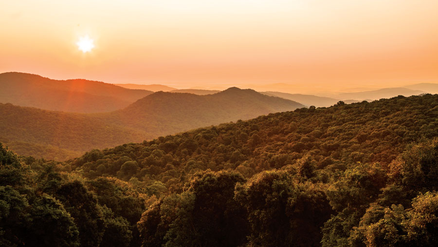
Virginia’s Shenandoah Valley has long attracted human interest. Its plethora of natural resources like water, minerals, and fertile soil nurtured early Native American populations. Unsurprisingly, when 18th century European trappers first laid eyes on the valley’s rolling ridges and open meadows, they saw opportunity. Though Shenandoah’s 300 square-miles would later see decades of logging and mines, it was that bounty of natural beauty that eventually secured the valley’s national park status in 1935.
Now, visitors can experience Shenandoah’s storied past by way of the park’s 500-plus miles of hiking trails, 101 of which include the Appalachian Trail (another National Park unit under the National Scenic Trail designation). Amid the fields of wildflowers and rhododendron tunnels runs Skyline Drive, the 105-mile backbone of Shenandoah National Park. The only public road through the park, Skyline’s paved route is popular among Sunday drivers and road cyclists, especially during peak fall colors.
Top Treks in Shenandoah
1. Old Rag, Nethers, Virginia
Likely the most popular hike in Shenandoah, the vistas atop Old Rag draw a crowd every weekend, regardless of the season. The circuit itself is certainly no walk in the park—it’s about eight miles round-trip with a steep section of rock scrambling that becomes even more heinous in wet and wintry conditions. Yet for those of us seeking solace in the woods, the trail will be the least of your problems. If you can bare the fraternity groups and middle school field trips you’ll likely find on any given weekend, the textbook Blue Ridge views at the summit are entirely worth the sweat. Avoid weekends and holidays, get up early, or play hooky to beat the crowds. Parking at the Old Rag trailhead is limited, so consider carpooling or hitchhiking (we encourage both). Camping is prohibited above 2,800 feet, and all backcountry campers are required to obtain a permit.
2. White Oak Canyon, Syria, Virginia
Shenandoah’s steep terrain certainly lends itself to rocks, on the one hand, but also tight and twisting streams, gentle cascades, and pounding waterfalls. Whiteoak Canyon is a little bit of all of that. With a total of six waterfalls ranging in height from 35 to 86 feet, the canyon is a mecca for swimming holes, but don’t expect to have the place to yourself. Though not as popular as nearby Dark Hollow Falls, Whiteoak Canyon is rarely empty on a hot summer’s day, and with good reason—the large pool at the bottom of the lower falls is deep, easily accessible, and the perfect place to cool off mid-hike. Climb the trail to the upper falls for a scenic view from above and an extra mile or two to your trip. This out-and-back hike is 4.9 miles round-trip from the parking lot off Skyline Drive at milepost 42.6 to the upper falls and back. The trail can be tricky at times, but is well-maintained and family friendly.
3. Austin Mountain—Furnace Mountain Loop, Crozet, Virginia
With challenging climbs, panoramic scenes, and creek crossings, this 13.3-mile hike embodies all that we love about Shenandoah National Park. Starting from Browns Gap parking lot off Skyline Drive at milepost 82.9, the climb begins gradually as you saunter up Madison Run Fire Road but quickly steepens once you cross Madison Run Creek (a wild brook trout haven, for all you anglers out there). Serious hikers can knock this trip out in a long day, completing the loop by way of the Appalachian Trail. For those looking to break the trip up over the course of two days, there’s a killer campsite big enough for a tent and some hammocks at the summit of Furnace Mountain. During peak thru-hiker season, you may encounter a few scraggly thru-hikers making their way along the white blaze, but for the most part, the difficulty and distance of this hike keep the crowds at bay.
4. Overall Run Falls, Bentonville, Virginia
At 93 feet, Overall Run Falls is the tallest waterfall in the park. Couple that with a hike that takes you through an area with pristine swimming holes and the highest concentration of black bears, and and you’ve got your new weekend go-to. Make a loop out of the normal 4.7-mile out-and-back by connecting Beecher Ridge, where you’re likely to sight that black bear we mentioned. The Beecher Ridge-Overall Run loop is only 8.5 miles total, but you’ll want to leave plenty of time to soak in the sights of Massanutten Mountain and Page Valley. Keep an eye out for side trails that lead to small campsites—you can extend your trip into a short overnighter by parking off Chrisman Road and following Heiskell Hollow Trail to its intersection with Mathews Arm Trail and the Tuscarora-Overall Run Trail. This 12.7-mile alternative hides homestead ruins in its undergrowth for those interested in the park’s history. Visit in early spring, or even winter, when heavy rains and snowmelt make the falls surge!
Great Smoky Mountains National Park, Tenn., N.C.
Established: June 15, 1934
Size: 522,427 acres
Peak: Clingmans Dome— 6,643’
Of the country’s 59 national parks, Great Smoky Mountains sees the highest annual visitation. In 2013 alone, more than 9.4 million visitors came to the park—that’s twice that of Grand Canyon National Park, which comes in with the second highest visitation at 4.6 million. Despite its popularity, the 800 square-miles of rugged land between North Carolina and Tennessee are some of the wildest areas east of the Mississippi. Finding solitude amid the Smokies’ 16 6,000-plus-foot peaks (and 850 miles of trail) is hardly a challenge, if you’re willing to work for it.
These high-elevation summits shelter more than great adventure. Some 1,600 species of flowering plants have made the Smokies their home, and from mid-June through mid-July, the mountainsides are covered in brilliant displays of mountain laurel, rhododendron, and azalea in bloom. The symbol of the Smokies, the American black bear serves as yet another example of the park’s inherent remoteness. With more than 1,500 bears patrolling the park’s interior, Great Smoky Mountains National Park is the largest protected bear habitat in the East.
Like a cherry on an adventurously decadent sundae, the park and all of its natural glory are free to the public. It’s one of the few parks in the country that does not charge an entrance fee.
Top Treks in the Smokies
1. Charlies Bunion, Gatlinburg, Tennessee
Stand atop Charlies Bunion and experience the wonder that inspired Bryson City writer Horace Kephart to advocate for the creation of Great Smoky Mountains National Park. Roughly 70 miles of the Appalachian Trail run through the Smokies, and it’s the A.T.’s white blazes you’ll follow to reach the dramatic rock outcropping that is Charlies Bunion. Begin at Newfound Gap parking lot, the site of President Franklin Roosevelt’s park dedication ceremony in 1934. From there, you’ll climb 1,600 feet over the course of four miles. It’s a butt-buster, so take your time. You’ll know you’ve arrived at Charlies Bunion when you spy a spur trail forking off to the left. The trail dead-ends into a sheer drop-off that will drop your jaw. Watch your footing when you’re posing for a selfie.
2. Abrams Falls, Tallassee, Tennessee
Saunter beneath pine-oak forests before descending into a lush world of hemlock groves and rhododendron thickets on this five-mile round-trip hike to Abrams Falls. The falls are only 20 feet in height, but their power is real. Naturally dammed by deadfall and rock, the otherwise idle Abrams Creek surges to life here. The pool below the falls looks appealing to swim in, and it is, but be forewarned—many injuries have occurred in the area surrounding the falls due to slick rock and hidden roots. Anglers will enjoy the wide, lazy bends in the creek around 1.6 miles in, so pack a rod. Though there are no designated camping sites in the immediate areas surrounding the Abrams Falls Trail, there are a few options on nearby Rabbit Creek Trail and Hannah Mountain Trail.
3. Mount Cammerer, Cosby, Tennessee
Rising above the northeastern fringe of Great Smoky Mountains National Park, Mount Cammerer practically straddles the North Carolina and Tennessee border. Named for Arno Cammerer, who served as Director for the National Park Service from 1933 until 1940, Mount Cammerer is two parts beauty, one part history. At the height of this 4,928-foot mountain looms a lookout tower built by the Civilian Conservation Corps in the late 1930s. Hikers can access the summit and tower by way of Low Gap Trail, which eventually links up to the A.T. A short spur trail leads to the mountain’s proper summit as well as 360-degree views of neighboring peaks like Mount Sterling, Snowbird Mountain, and below, the Pigeon River Gorge. Plan for a long day on the trail, as the out-and-back trek totals 11 miles.
4. Ramsey Cascades, Gatlinburg, Tennessee
The 100-foot Ramsey Cascades, the tallest waterfall in the park, is certainly a sight worth seeing, but it’s the stands of old-growth forest that really make this hike spectacular. It’s an eight-mile out-and-back hike and it’s tough, steadily climbing 2,200 feet to the base of the falls. During the last two miles before you reach Ramsey Cascades, giant tulip trees, basswoods, silverbells, and yellow birches emerge from the forest. Be on the lookout for red maple, white oak, and black cherry trees of substantial size, too—some of the park’s tallest trees will be all around you. Use the Greenbrier entrance to the Smokies to access this special gem.

Blue Ridge Parkway, Va., N.C.
Established: June 30, 1936, completed 1987
Size: 469 miles
Peak: Richland Balsam Overlook, N.C.—6,047’
The Blue Ridge Parkway is more than just a road. It’s a park, a ribbon of adventure, a physical map of times long past. It does more than provide access to the mountains it connects— it protects them, too. Winding for 469 miles from central Virginia to western North Carolina, the Blue Ridge Parkway seamlessly joins Shenandoah National Park with Great Smoky Mountains National Park. With nearly 300 overlooks and hundreds more trail access points, the parkway is a never-ending source for inspiration, recreation, and even education. Along the way, drivers will see prehistoric and early settlement infrastructure as well as traces of industries that once fueled Appalachia. Drive, bike, or hike through the decades and along the parkway that pays homage to the mountains we hold so dear.
Top Treks Along the Blue Ridge Parkway
1. Rough Ridge, Boone, North Carolina
Short on time? Need a new leaf peeping spot? The Rough Ridge Overlook is your answer. Just a short, but steep, trek from the parking lot reveals a sprawl of mountain ranges filing one behind the other as far as the eye can see. It’s enough of a scene to make you feel small and insignificant. Even the Linn Cove Viaduct, visible from the summit of Rough Ridge, is dwarfed in the shadow of Grandfather Mountain. The boardwalks and stairs seem unnatural, but are meant to protect the fragile mountain-heather ecosystem that carpets the hillside. The path is part of the 13-mile Tanawha Trail, which parallels the parkway between Julian Price Park and Beacon Heights. If you have a second vehicle, you can extend your hike up Rough Ridge to include more of the Tanawha system.
2. Apple Orchard Falls, Buchanan, Virginia
This 5.6-mile loop around Apple Orchard Falls is a cure-all for even the worst of hot summer days. The trail is cool and shady from the canopy above, with multiple creek crossings and opportunities to splash your face. The falls themselves, which tumble some 200 feet down house-sized rocks, usually always have water, regardless of the amount of recent rainfall. This particular loop is easily doable in a day, but why rush it? There are ample amount of campsites sprinkled throughout the forest, and with such ready access to water, you can easily set up a base camp and explore other sections on Cornelius Creek and the Appalachian Trail.
Best of the Rest
BOOGERMAN TRAIL, situated in Cataloochee Valley, is named not for the Boogeyman but, rather, Robert Palmer, one of the few locals who refused to allow timber companies to log on his property during the early 1900s. Thanks to Palmer, whose childhood nickname “Boogerman” carried into adulthood, this trail shelters some of the tallest trees in the Cataloochee Valley.
BIG BUTT Mountain and Trail rises above Buncombe and Haywood counties in North Carolina. In geographic lingo, “butt” refers to an abrupt end of a ridge or mountain. Consequently, the landscape here is craggy with rock fins and abutments around every corner.
CHARLIES BUNION is a rock outcropping from which you can view Mount Le Conte on a clear day. Horace Kephart supposedly penned the name in 1929 during a hike with Swain County native Charlie Conner, photographer George Masa, and others. During a break, Conner removed his boots and exposed a bunion that, to Kephart, looked every bit as impressive as the surrounding rock features. Kephart reportedly told Conner, “Charlie, I’m going to get this place put on a government map for you.”
STANDING INDIAN looms nearly 5,500 feet above the southern Nantahala Forest. Its summit is the tallest peak south of the Smokies. Legend has it that the mountain takes its name from a sentinel, a Cherokee Indian warrior sent to the summit to keep watch for the winged monster that had stolen a child. The watchman turned to stone when a lightning storm struck the mountain, killing the monster and creating the treeless summit for which Standing Indian is known.
PEAKS OF OTTER in Virginia would, you think, reference a native river otter population residing in the 24-acre Abbott Lake, yet there are no known otters in the area. The most commonly accepted explanation for the name stems back to Charles and Robert Ewing, two brothers who came to the area from Scotland around 1700. Supposedly, the Ewing brothers named a number of streams and hills after destinations in their home country. “Otter” is used quite frequently in Scotland place names.
GRAVEYARD FIELDS in North Carolina is just that—a haunting reminder of times long past. Once a seemingly impenetrable evergreen forest, a freak windstorm several hundred years ago uprooted the spruce forest leaving only stumps in its wake. With two detrimental fires in 1925 and again in the 1940s, as well as the presence of logging in the area, the present-day open expanse is the result of natural and manmade forces alike.
OLD RAG is anything but a decrepit piece of cloth. Sometimes called “Old Ragged Top,” Old Rag Mountain received its name due to the irregular ridgeline and unusually rocky nature.
STONY MAN is, you guessed it, a mountain with a lot of stones that looks a little bit like a bearded man. No one knows who first dubbed the summit “Stony Man,” but by 1895, the name was commonplace.
MCAFEE KNOB is well known among hikers for its stunning, panoramic views of the surrounding Catawba Valley, Roanoke Valley, Tinker Cliffs, and North Mountain, but did you know that the summit itself takes its name from James McAfee? McAfee was a Scots-Irish immigrant who settled in the Catawba Valley in the late 1730s.
THE PRIEST is certainly holy in its grandeur. It stands some 4,000 feet above Nelson County, Va. While some theories suggest The Priest was named after the DuPriest family that lived in the area, many others believe a local minister saw the nearby mountain peaks like a church away from church. The Cardinal and The Friar are neighboring peaks to The Priest, and together, these summits form the Religious Range.


