Save the roadside dips for the tourists. These 10 swimming holes require some effort to get to, but if you’re willing to work for the plunge, the cool mountain water and scenery are worth it.
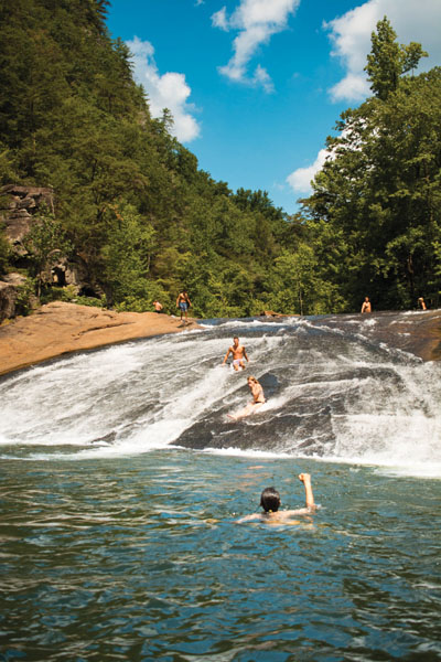
Bridal Veil Falls
Tallulah Gorge State Park, Georgia
Distance: 3.4 miles
Difficulty: Moderate
There is so much to love about this Georgia gem. Meandering along state lines for two miles, the 1,000-foot chasm yawns open from the forest’s womb, revealing raging whitewater that tumbles through near-vertical granite walls. It’s an impressive sight, no matter where you’re standing (or, for some of our readers, floating), and would have been even more remarkable were it not for the dam constructed in the early 1900s.
Still, it’s the pride and joy of Georgians. Over 200,000 visitors make the annual journey to the gorge, placing it among Georgia’s most popular state parks. But if you can secure one of the 100 daily permits (easier said than done on a weekend) that allow you to access the gorge floor, you can escape the mobs of selfie-takers at the overlooks.
Eastatoe Gorge
Eastatoe Creek Heritage Preserve, South Carolina
Distance: 5 miles
Difficulty: Moderate
If blissful seclusion, old-growth forests, and diverse flora are what you seek, The Narrows at Eastatoe is the answer. This 300-acre preserve is a little slice of urban sanctuary for Upstaters looking to escape the bustle of city living. An hour practically due west from Greenville and tucked into the tri-state fold of the Georgia-North Carolina-South Carolina state lines, Eastatoe is largely overlooked due in large part to its proximity to summer hotspots like Lake Jocassee and Gorges State Park.
We would like that to change. Though overnight camping is no longer permitted in the preserve (due to an increased number of downed hemlock trees), there is plenty here that makes a day trip worthwhile, namely crisp mountain water and wild rainbow trout. The Eastatoe Gorge Trail is a spur off of the Foothills Trail and is about as diverse as the forests through which it passes. Beginning as an old logging road before merging into a classic footpath, the hike to The Narrows takes visitors through cove and upland hardwoods before descending into the lush hemlock canopy where rare ferns like the Tunbridge Fern (which exists nowhere else in North America) thrive. The aptly named “Narrows,” which plummets 600 feet in elevation through tight and twisting rock channels, is not a quiet, family friendly swimming hole. It’s the creek crossings, knee-deep in places, where you’ll find your mid-hike dunk. That water is pretty frigid, so even if you could swim laps, you probably wouldn’t last long enough to do so.
Northrup Falls
Colditz Cove State Natural Area, Tennessee
Distance: 2 miles
Difficulty: Easy
Named in honor of the family who settled in this rugged pocket of Tennessee, Northrup Falls was the site of Northrup mill during the 1800s. Marvelous in setting, but no doubt steep in terrain, it’s a wonder any family could carve a life for themselves out of this jungle of twisting mountain laurel and hemlock. Today, the 60-foot-waterfall is the jewel of Colditz Cove State Natural Area, a 165-acre protected tract of land that houses Black Mountain dusky salamanders, pygmy shrews, and legends past of cliff-dwelling Woodland Indians who hunted the forest here more than 3,000 years ago.
This hike is absolutely worth the extra time in the car to reach it. About an hour and a half northwest of Knoxville, the Colditz Cove State Natural Area is not far from the Big South Fork National River and Recreation Area near the Tennessee-Kentucky border. Bring a camera—the waterfall here is not unlike an amphitheater in its design, with layers of rock ledges rounding out the cove like a cul-de-sac.
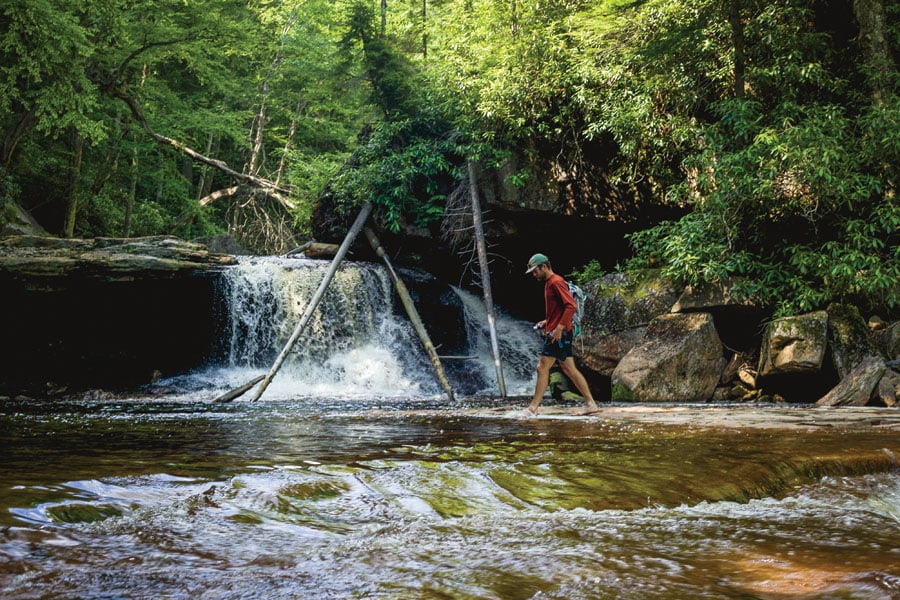
Stinging Fork Falls
Stinging Fork Falls State Natural Area, Tennessee
Distance: 3 miles
Difficulty: Easy
Another one of Tennessee’s underrated public lands is the Stinging Fork Falls State Natural Area, a gorgeous 783-acre chunk of forest located smack dab in the middle of the state. The falls for which this natural area is named is humble in height, tumbling for 30 feet through a relatively narrow slot, but the unspoiled pool below has to be one of the most picturesque places to swim we’ve ever seen.
For a quick-and-easy outing, this hike has everything that makes the Cumberland Plateau such a special place—jagged bluffs, lush rhododendron-cloaked understory, trickling cascades surging with life. After you take a dip at the falls, check out the short spur trail to the overlook at Indian Head Point to see the gorge from a different point of view.
Virgin Falls
Virgin Falls State Natural Area, Tennessee
Distance: 9 miles
Difficulty: Strenuous
Less than two hours’ drive from downtown Chattanooga is perhaps one of the most unique examples of water’s awe-inspiring power. Virgin Falls Pocket Wilderness, as Bowater Pulp and Paper Corporation originally deemed it in 1973, is defined by its karst topography. Virgin Falls itself forms underground before rising through the porous ceiling of a cave. It then falls more than 100 feet before disappearing altogether into another cave. It’s because of these unusual sink features that the “pocket wilderness” became an official state recreation area in 2012 thanks to a partial grant by the U.S. Fish and Wildlife Service.
Three other waterfalls accompany Virgin Falls on this hike, including Big Laurel Falls, Sheep Cave Falls, and Big Branch Falls. Along the way, you’ll pass sinkholes, boulder fields, caves, and vistas overlooking the Caney Fork River and Scott’s Gulf areas. Due to the unfortunate realities of white nose syndrome, entering caves is prohibited at this time. Primitive camping is allowed here, but please be respectful visitors and leave this sensitive place as pristine as you found it.
Wildcat Falls
Joyce Kilmer-Slickrock Wilderness Area, North Carolina
Distance: 12 miles
Difficulty: Strenuous
Straddling the North Carolina-Tennessee border for more than 17,000 acres, the Joyce Kilmer-Slickrock Wilderness Area preserves some of the most sacred waters and virgin forests of the Nantahala and Cherokee national forests. Dedicated as a memorial to Alfred Joyce Kilmer, who penned the poem “Trees” (“I think that I shall never see/ A poem lovely as a tree.”), this wilderness area has long been touted for that very asset, trees. Joyce Kilmer-Slickrock is widely regarded as the home of the largest tract of old-growth forest in the East. You’ll no doubt revel in those impressive boughs when you visit, but for this trip, it’s Slickrock Creek that will be the center of attention.
The very lifeblood of this wilderness, Slickrock Creek runs like an artery between the two states, serving as the actual border between North Carolina and Tennessee for some miles. Countless smaller tributaries, with memorable names like Naked Ground Branch and Hangover Creek, feed into Slickrock on its way to Calderwood Lake. For obvious reasons, this is prime native brook trout territory and even anglers will have to hike at least two miles in to access any of those crystal clear waters.
Wintergreen Falls
DuPont State Forest, North Carolina
Distance: 3.2 miles
Difficulty: Easy
Often overshadowed by the blockbuster waterfalls of DuPont State Forest like Triple Falls, Bridal Veil Falls, Hooker Falls, and High Falls, Wintergreen Falls is just as stunning as its cascading brethren but hardly gets the traffic. That’s probably because it’s cordoned off in its own little neck of the woods, farther east of the high-volume trails and waterfalls most tourists visit. At 15 feet in height, it’s certainly no pounding 100-foot curtain of thunder, but you’re here for the swimming, not the waterfall viewing, am I right?
You can make this romp to Wintergreen as long or as short as you’d like. Mountain bikers may want to park in some of the main parking areas near the forest’s entrance to work up a sweat before reaching the falls, while hikers (maybe with kiddos in tow) can opt for the 1.5-mile hike-in. Take your furry four-legged friend (we’re talking dogs here, not llamas) along for the dip, but be sure to keep them on a leash.
Overall Run
Shenandoah National Park, Virginia
Distance: 8.5 miles
Difficulty: Moderate
At 93 feet in height, most people know Overall Run as Shenandoah National Park’s tallest waterfall. It’s certainly a waterfall worth checking out, but don’t be disappointed if you visit in the summer—dry spells can reduce this normally powerful flow to a mere trickle. Fortunately those low flows aren’t enough to dry up the pools at the bottom of the falls. There are three pools here that are deep enough to consider swimmable, so even if there are some other visitors at Overall Run, you can lay claim to your own slice of mountain stream paradise.
For those unfamiliar with Shenandoah National Park, this hike will hit all the high points—meadows, black bear sightings, postcard-worthy valley overlooks. You can’t beat the Shenandoahs in summer.
Cascade Falls
Jefferson National Forest, Virginia
Distance: 8.4 miles
Difficulty: Moderate
This 69-foot-waterfall is definitely one of the most popular destinations on this list, but we would be remiss to omit it. With 200-foot canyon walls, a massive swimming hole at its base, and plenty of quiet hiking past the falls themselves, Giles County’s pride and joy is popular for all of the right reasons.
The Cascades National Recreation Trail follows Little Stony Creek upstream from the parking lot to the falls. With stunning bridges and impressive natural rock work, you’d be hard-pressed not to take a photo around every bend in the trail. The vast majority of visitors will not venture past the falls, but just a few miles farther down the trail is Barney’s Wall. Here, hikers will come upon 700-foot vertical cliff faces overlooking the idyllic New River Valley towards Blacksburg, Virginia. Make sure your memory card is empty when you set out—the photo opps just keep coming.
Forks of Red Creek
Dolly Sods Wilderness, West Virginia
Distance: 10.6
Difficulty: Moderate
There’s a reason Dolly Sods is considered one of the wildest places east of the Mississippi. The Arctic-like flora, fauna, and conditions can make even summertime trips to the Sods feel unexpectedly out-of-season. The weather here has a mind of its own, so don’t be surprised if you plan a grand swimming hole expedition only to get socked in with fog, rain, and temps in the 50s.
On the rare chance that the skies are clear and the weather divine, you’re in for a real treat. Red spruce, open meadows, and tannin-stained waters dominate the Sods’ highlands. Being a wilderness area, none of the trails are marked here, which is just one of the factors in its wild feel. Of course, the Sods’ reputation for remoteness is not unheard of. The access road to Dolly Sods is often packed on fair weather weekends, especially once the blueberries and blooming mountain laurel are in. Don’t let that deter you—within a few minutes of hiking, you’ll feel like you’re miles from civilization.


