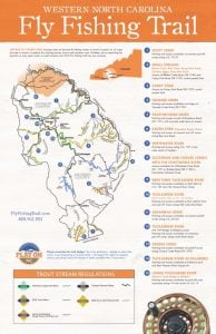
It’s no secret that Jackson County is home to some of the best trout fishing this side of the Mississippi River, but did you know that this Western North Carolina county is also the birth place of the country’s first and only fly fishing trail?
That trail was established back in 2009 with the help of county officials and longtime local anglers. Alex Bell, who guides on the Tuckaseegee River and other Jackson County waterways, was one of several local fisherman instrumental in developing all fifteen points along the trail.
“It just sort of evolved,” Bell said of the Western North Carolina Fly Fishing Trail. “We all sat around, got the maps out, showed places that we’d fished and been successful and came up with the fifteen spots that are currently on the map.”
These brain storming sessions by Bell and other local anglers have resulted in a rare cache of insider info that’s been aggregated, mapped, and is now available, free of charge, to anyone with an interest and a desire to fish Jackson County’s plethora of top-notch trout streams.
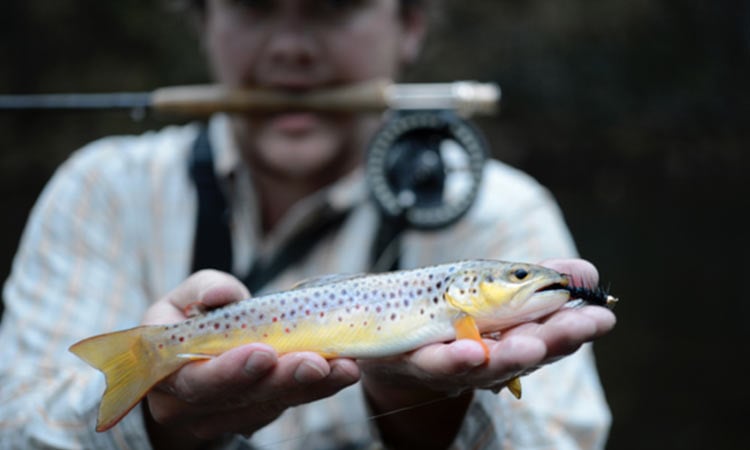
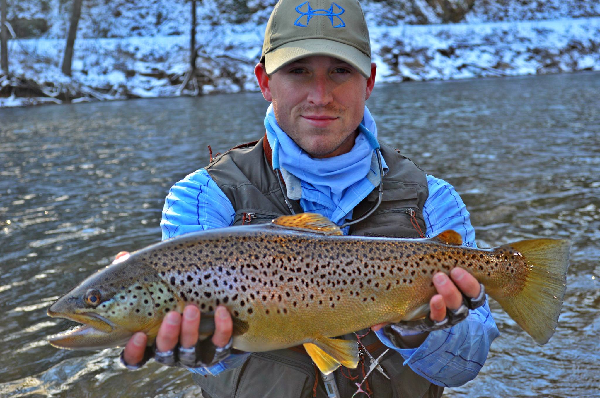
I had the opportunity to fish with Alex on the Tuckaseegee River last November, and the trip did not disappoint. I highly recommend his services if you’re ever looking for friendly, knowledgable guide in the area.
Check out the details on all 15 fly fishing hot spots below, visit flyfishingtrail.com to download your own copy of the Western North Carolina Fly Fishing Trail map, and start ticking these prime stretches of trout water off your to-do list this weekend!
1). Scott Creek
The Stretch: roughly 10 miles from the headwaters near Balsam, NC down to Sylva, NC
Access Point(s): Parking and access available via several pull-off areas along U.S. 23/74
Type of Water: Hatchery Supported
Available Fish: Brown, Rainbow
Numbers or Size: Numbers
Noteworthy: Stretch also includes North Fork Scott Creek and Buff Creek, which are very scenic
2). Small Streams
Moses Creek, Mull Creek, Rough Butt Creek, Chastine Creek, Piney Mountain Creek
The Stretch: Collection of small streams in eastern Jackson County, below Blue Ridge Parkway
Access Point(s): Via Moses Creek Rd (SR 1740) & Caney Fork Rd (SR 1737), avoid posted land
Type of Water: Wild Trout
Available Fish: Brook, Rainbow
Numbers or Size: Numbers
Noteworthy: Mountainous terrain, includes several large waterfalls
3). Caney Fork
The Stretch: Roughly 10 miles from East Laporte Park to headwaters at fork of Mull Creek and Piney Mountain Creek
Access Point(s): Access via Caney Fork Road (SR 1737), avoid posted land
Type of Water: Undesignated
Available Fish: Rainbow, Brown, occasional Brook
Numbers or Size: Numbers
Noteworthy: Respect private land owners
4). Tanasee Creek
The Stretch: Roughly 2-3 miles from Tanasee Creek bridge up to headwaters
Access Point(s): Parking and access available at bridge on Tanasee Creek Road (SR 1762)
Type of Water: Wild Trout
Available Fish: Brown
Numbers or Size: Both
Noteworthy: Very scenic stretch in the Nantahala National Forest
5). Panthertown Creek
The Stretch: Entire stream, roughly 3 miles
Access Point(s): Parking and access at end of Breedlove Rd (SR 1121), with 2-mile walk to creek
Type of Water: Catch & Release Single Hook Artificial Lure
Available Fish: Brook
Numbers or Size: Numbers
Noteworthy: Located in Panthertown Valley, which is known as the “Yosemite of the East” because of its bowl shape and rocky bluffs
6). Raven Fork (Cherokee Trophy Water)
The Stretch: Starts at Blue Ridge Parkway bridge near Cherokee and goes north for 2.2 miles
Access Point(s): Parking & access via several pull-off areas along Big Cove Road; paths run along stream
Type of Water: Catch & Release Fly Fishing Only
Available Fish: Golden, Rainbow, Brown, Brook & Donaldson trout
Numbers or Size: Both
Noteworthy: This stretch is also called Cherokee Trophy Water and fish of 20-30 inches are common; Cherokee annual permit and daily permit required
7). Whitewater River
The Stretch: Roughly 2-3 miles from Hwy. 107 down to the South Carolina state line
Access Point(s): Parking and access along N.C. 107, a few miles south of Cashiers
Type of Water: Wild Trout
Available Fish: Brook, Brown and Rainbow
Numbers or Size: Numbers
Noteworthy: Flows into Whitewater Falls, the highest waterfall east of the Mississippi
8). Scotsman and Fowlers Creek into Chattooga River
The Stretch: Roughly 2-3 miles of each stream flowing down into the Chattooga River
Access Point(s): Access available via Whiteside Cove Rd (SR 1107) or Bullpen Rd (SR 1100) in Nantahala National Forest
Type of Water: Wild Trout with Natural Bait
Available Fish: Brown, Rainbow
Numbers or Size: Numbers (creeks), Size (Chattooga)
Noteworthy: The movie Deliverance was filmed on the Chattooga River
9). West Fork Tuckaseegee River
The Stretch: From small reservoir at Thorpe Power House upstream several hundred yards
Access Point(s): Parking and access available both sides of N.C. 107 near Thorpe Power House
Type of Water: Hatchery Supported
Available Fish: Brown, Rainbow
Numbers or Size: Numbers
Noteworthy: Although hatchery supported, this has nice concentration of stream-raised fish
10). Tuckaseegee River (East LaPorte Park to NC 107 Bridge)
The Stretch: Roughly 2-3 miles from park to bridge
Access Point(s): Parking and access available at East Laporte Park and pull-off areas along Old Cullowhee Road
Type of Water: Hatchery Supported
Available Fish: Rainbow, Brook and Brown
Numbers or Size: Numbers
Noteworthy: East Laporte Park has picnic tables and public restrooms
11). Savannah Creek
The Stretch: About 10 miles from headwaters in Pumpkintown into Tuckaseigee River
Access Point(s): Parking and access available via several pull-offs along U.S. 23/441
Type of Water: Hatchery Supported
Available Fish: Rainbow, Brown
Numbers or Size: Numbers
Noteworthy: Access limited the closer you get to the Tuckasegee River
12). Tuckaseegee River (NC 107 Bridge to Dillsboro park)
The Stretch: Roughly 4-5 mile stretch from bridge to the riverside park in Dillsboro
Access Point(s): Parking and access available via numerous pull-offs along North River Road
Type of Water: Delayed Harvest
Available Fish: Brook, Brown and Rainbow
Numbers or Size: Both
Noteworthy: Best place to achieve the Tuckaseigee Slam (catch all three species in one spot)
13). Greens Creek
The Stretch: About 3-4 miles from Macon County line to Savannah Creek
Access Point(s): Various places along Greens Creek Road (SR 1370)
Types of Water: Wild Trout, Undesignated, Hatchery Supported
Available Fish: Rainbow, some Brown
Numbers or Size: Numbers
Noteworthy: Portion of the creek flows through the Nantahala National Forest
14). Tuckaseegee River (in Dillsboro)
The Stretch: About 1 mile from Dillsboro park through town
Access Point(s): Various places between park and Best Western River Escape Inn
Type of Water: Hatchery Supported
Available Fish: Rainbow, Brown
Numbers or Size: Size
Noteworthy: Includes two lodging options: Best Western River Escape Inn and Dillsboro Inn
15). Lowe Tuckaseegee River (Barker’s Creek Bridge to Whittier)
The Stretch: Roughly 8-10 miles from bridge to Whittier
Access Point(s): Parking and access via pull-offs and businesses along U.S. 19/74 freeway
Type of Water: Hatchery Supported, Undesignated
Available Fish: Rainbow, Brown
Numbers or Size: Size
Noteworthy: The stretch is also home to smallmouth bass\
More from the Fridays on the Fly Blog:


