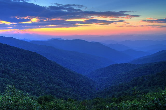
Wilderness, with a capital “W,” is the most comprehensive and permanent form of environmental protection available, reserved for only the finest examples of North American forests. For hikers and backpackers, the Wilderness designation serves as a stamp of approval, an indicator that what lies within those federally designated borders is pristine and primal. According to the Wilderness Act, these few remaining forests are places where “the earth and its community of life are untrammeled by man.” As humans trammel more and more of the planet, Wilderness areas have never been more important—both scientifically and spiritually. They are also some of the most popular destinations for recreation, particularly here in the heavily developed Southeast, where ecosystems of such pristine character are especially rare.
♦
“Once you call a place Wilderness, it becomes a destination that everyone wants to visit,” says Jim Murray, president of the Virginia Wilderness Coalition, which played an integral role in helping pass the Virginia Ridge and Valley Act. “We all want to go into the woods and find solitude and nature as it was intended.”
Wayne Jenkins, executive director of the Georgia Forest Watch, thinks the attraction that we have for Wilderness is in our DNA. “We have this built-in desire for finding solitude and exploring nature at its most primal and rugged edge. You see it played out every weekend in North Georgia. We’re all trying to get away from each other, flooding the highways that lead into the Chattahoochee National Forest.”
The Chattahoochee National Forest is home to the Cohutta Wilderness, a victim of the ironic twist that pits so many people in search of such pristine isolation. The Cohutta is one of the most heavily used Wilderness areas in the country. Overuse is such an issue that the U.S. Forest Service banned overnight use near Jacks River Falls, a popular 50-foot waterfall in the heart of the Wilderness.
The Cohutta isn’t the only overused Wilderness area in the Southeast. Shining Rock Wilderness in Western North Carolina receives more than its share of hikers, thanks in part to its astonishing scenic beauty. In Virginia, hoards of hikers flock to the Saint Mary’s Wilderness swimming holes, which look more like crowded swimming pools on summer weekends. And the views from atop of the Dolly Sods Wilderness in West Virginia have become a must-see destination for the masses.
“The only answer to the paradox we’re experiencing is to have enough places designated as Wilderness so that no one place gets overused,” Murray says. “Luckily, there are still plenty of places worth designating.”
To help disperse recreation within Southeastern Wilderness areas, use the following guide to find alternatives to the South’s most popular Wilderness hikes. These trails offer similar scenic beauty, unparalleled backcountry experiences, and only a fraction of the crowds.
—
Jacks River Trail (Georgia)
Cohutta Wilderness, Chattahoochee National Forest
This hike follows the pristine Jacks River for 16 miles, forcing hikers to cross the creek a record 40 times. Along the way, you pass Jacks River Falls, a 50-foot waterfall complete with rock jumps, swimming holes, and big crowds. Jacks River is one of the most popular trails in the entire national forest.
Iron Mountain Trail (Georgia)
Cohutta Ranger District, Chattahoochee National Forest
Iron Mountain sits just outside the designated borders of the Cohutta Wilderness, towards the Tennessee border, but it traverses terrain similar to what’s found inside the Wilderness with none of the crowds. The irony here is that you’ll actually get more of a backcountry experience by stepping out of the Wilderness onto the Iron Mountain. Along the trail’s four-mile journey, you’ll cross the deep Conasauga River, pass through wildlife clearings, and have expansive views of the Cohutta Mountains from a ridgetop section. Hook it up with the Conasauga River Trail for a 12-mile loop that includes even more river crossings.
Jack’s River is famous for the plunge swimmers take over the falls by the same name. You won’t find a waterfall jump to equal the Jacks River Falls on this alternate hike, but most of the river crossings on the Conasauga are near pools deep enough to swim in. And you won’t have to share your swimming hole with the crowds that swarm Jacks River Falls.
Appalachian Trail side trip through the Laurel Fork Gorge (Tennessee)
Pond Mountain Wilderness, Cherokee National Forest
This short stretch of the old A.T. near Watauga Lake cuts through the heart of the scenic Laurel Fork Gorge leading to Laurel Falls, a 50-foot tall, picturesque waterfall.
Grassy Branch Trail (Tennessee)
Citico Creek Wilderness, Cherokee National Forest
Citico Creek is the largest Wilderness area in Tennesee, stretching 16,226 acres across the southeastern corner of the state where it connects with the Joyce Kilmer/Slickrock Wilderness in North Carolina. The remote Wilderness receives a fraction of the visitors that Pond Mountain receives, so you’ll likely have the Grassy Branch Trail to yourself. Try to count how many times you cross the creek on this 3.2-mile hike. If you’re not too soggy, continue on the South Fork Citico Creek Trail, which follows the creek deeper into the heart of the Wilderness, passing old growth trees and stellar campsites.
Still looking for the quintessential waterfall experience that the Laurel Fork Gorge presents? Head over to Falls Branch Falls inside the Citico Creek Wilderness. It’s a picturesque 60-footer that cascades over a slick granite gorge wall. The difficult two-mile hike on Falls Branch Trail keeps most visitors out, so you’re likely to have the falls and the 150 acres of potential old growth hemlocks and tulip poplars to yourself.
The Art Loeb Trail (North Carolina)
Shining Rock Wilderness, Pisgah National Forest
This 32-mile trail has been the darling of the national magazines during the last few years, and it’s received the bump in users to prove it. Hikers are particularly fond of the short stretch that crosses Black Balsam before dipping into the Wilderness area near the Blue Ridge Parkway. From the top of Black Balsam, you feel as if you can see all of the Southern Appalachians.
Green Mountain Trail (North Carolina)
Middle Prong Wilderness, Pisgah National Forest
The Middle Prong was designated as Wilderness partly to relieve some of the hiker traffic that neighboring Shining Rock received. It doesn’t seem to have worked. The smaller, slightly more remote Middle Prong is relatively ignored compared to its more famous neighbor. Hike the six-mile Green Mountain trail for a taste of what you’ve been missing. The hike summits Green Knob, a 5,900-footer complete with a grassy ridge and views of Sam’s Knob, Black Balsam, and the rest of the Shining Rock Highlands. The trail is unmarked and faintly traveled so pay attention as you cross the open grassy meadows on your way to the summit. Along the way, you’ll ford creeks, pass seasonal waterfalls, duck through rhodo tunnels, and get stuck in high elevation peat bogs. And from the summit of Green Knob, you might even be able to see all the hikers and cars parked at Black Balsam.
Shining Rock Wilderness is famous for its 6,000 footers, but the 5,900-foot Green Knob offers comparable views. Just think, if Green Knob were 100 feet taller, it might receive the hordes of hikers that nearby Black Balsam gets.
The Red Creek Trail (West Virginia) runs through the heart of the Dolly Sods Wilderness, an area defined by its rocky plains with big vistas. Hikers get to ford Red Creek twice on this particularly rocky hike which leads you through high elevation forests more indicative of Canadian ecosystems.
Canyon Rim Trail (West Virginia)
Roaring Plains West Wilderness
Technically, this is a user created trail that’s unofficially been adopted into the Roaring Plains West trail system. And it’s a good thing. Canyon Rim follows the edge of a one-mile wide, 2,000-foot deep gorge that runs for three miles in the West Virginia high country. The trail is faint and only marked by rock cairns, which you’ll have to consciously locate as you hike through boulder fields with some of the best views in the Mountain State. You’ll get the grassy meadows with big views, wild spruce shaped by the wind, high elevation bogs, and views all the way to Seneca Rocks.
Roaring Plains is one of the newest additions to West Virginia’s Wilderness stock, and officially became protected as Wilderness when Obama signed the Wild Monongahela Act (part of the Omnibus Public Land Bill) on March 30, 2009. It consists of one of the highest plateaus in the Eastern U.S. The Plains is surrounded by popular recreation areas like Seneca Rocks, Spruce Knob, Dolly Sods, and Canaan Valley.
Saint Mary’s River Trail (Virginia)
Saint Mary’s Wilderness, George Washington National Forest
This short hike close to the Blue Ridge Parkway follows the Saint Mary’s River and its series of waterfalls, most of which come complete with swimming holes. The hike has become a popular escape during the hottest months of summer.
Rowland’s Creek Falls and Jerry’s Creek Trail (Virginia)
Seng National Scenic Area, Jefferson National Forest
What’s a National Scenic Area? It’s the compromise that some Wilderness advocates in Virginia have spearheaded in order to bring mountain bikers into the Wilderness fold. The NSA gives an area many of the same protections that Wilderness affords, but allows for mountain biking on select trails. The Seng National Scenic Area will permanently protect 5,192 acres, while allowing mountain bikers to continue to enjoy the 12-mile Rowland’s Creek-Jerry’s Creek loop. As a hiker, you’ll also dig this route, which allows you to rock hop through Jerry’s Creek and scramble to the base of the 50-foot Rowland’s Creek Falls. Jerry’s Creek and Rowland’s Creek may not offer the collection of swimming holes that Saint Mary’s boasts, but the creeks are as pristine as you can find in the Southern Appalachians, and wild brook trout hide in shady corners. Bonus: The loop hike will also take you past 216 acres of possible old growth forest.
Old is the new New
There’s nothing “new” about the chunks of Virginia and West Virginia mountains that were recently designated Wilderness in the Omnibus Public Lands Bill—in fact, the ancient character of the forests contributed to their overall Wilderness qualifications. But the federal designations are new, and there’s something about freshly minted Wilderness that gets hikers excited.
“When an area gets a capital ‘W,’ people get excited about exploring some of these places that they never would have heard of unless they were federally protected as Wilderness,” says Mike Costello, executive director of the West Virginia Wilderness Coalition.
Here’s a look at the stellar recreation that awaits the intrepid explorer in some of the newly designated Wilderness areas in Virginia and West Virginia.
West Virginia
Big Draft Wilderness, Monongahela National Forest (West Virginia)
This 5,242-acre tract of forest has been a popular hiking destination for locals of Lewisburg and White Sulphur Springs for years. Big Draft sits between the Blue Bend Recreation Area and the Greenbrier River, making it one of the most accessible Wilderness areas in the Mon. Check out the Anthony Creek Trail, which follows the river of the same name for four miles, providing access to the creek’s many swimming holes. Boaters also take note: Anthony Creek provides five miles of class I-III whitewater through the heart of the new Wilderness Area.
Spice Run Wilderness, Monongahela National Forest
You want solitude? How about a 7,000-acre chunk of steep forest that requires fording the Greenbrier River to access? The Spice Run is now one of the most remote Wilderness areas in the Monongahela, sandwiched by the Greenbrier River, Calvin Price State Forest, and mountainous private land. There are no designated trails within the new Wilderness, so bushwhacking and orienteering are a must if you want to explore Spice Run.
“This is where you go if you want that true, rugged backcountry experience that you can’t always find on designated trails,” says Mike Costello, executive director of the West Virginia Wilderness Coalition.
There’s an old dirt road along the ridge that separates the new Wilderness area from Calvin Price State Forest, and another that climbs Slab Camp Mountain, the highest point within the Wilderness. Besides these two un-maintained grades, Spice Run is a blank canvas.
Cranberry Wilderness Expansion, Monongahela National Forest
Representing the largest chunk of new Wilderness to be designated in the Wild Monongahela Act, the Cranberry Expansion adds 12,000 acres to the already sizable Cranberry Wilderness. With the new acreage factored in, the Cranberry is now the third largest Wilderness area east of the Mississippi. The expansion beefs up the Cranberry’s western flank, and is dissected by half a dozen mountain streams. For a trip that runs through the “old” Cranberry and “new” Cranberry, hike the 22-mile North-South Trail, which crosses the Wilderness area on high ridges, connecting the Cranberry and Tea Creek Campgrounds.
Virginia
Stone Mountain Wilderness, Jefferson National Forest
The 3,270-acre Stone Mountain Wilderness might be small in size, but it pays off big in dividends. This block of the Jefferson is considered to be the “least disturbed tract of forest in Southwest Virginia” by Wilderness researchers and offers a couple of rugged trails and 100 acres of potential old growth oak, maple, and 300-year-old eastern hemlocks. The 14.2-mile Stone Mountain Trail climbs the crest of Stone Mountain largely without the aid of switchbacks. The trail is steep, the footing is rugged, and the views from the ridge top stretch into Kentucky. You’ll also pass massive boulders and vertical cliff faces. If it’s hot, take the side trip to Keokee Lake, a secluded 92-acre lake that sits just outside the Wilderness border.
Raccoon Branch Wilderness, Mount Rogers National Recreation Area
Dickey Creek is a trout stream running along the southern border of the newly designated Wilderness. The terrain climbs up the slope of the long Dickey Ridge, which peaks at 4,000 feet along a four-mile section of the Appalachian Trail. The area receives the heaviest traffic from A.T. hikers and equestrians using the Virginia Highlands Horse Trail, which runs through the heart of the new Wilderness area. But step off of these two thoroughfares and you’ll get a taste of the solitude Wilderness affords. Check out Dickey Knob Trail, which starts at the confluence of Dickey Creek and Raccoon Branch and climbs 2.5 miles to the 3,649-foot Dickey Knob (former site of a fire tower) which has views of the Rye Valley to the north. And the long forgotten and much overgrown Scott Branch Trail in the southeastern section of the Wilderness probably offers the best chance for solitude. This 1.5-mile trail doesn’t even show up on most maps of the area.


