It’s not as easy to get lost in Panthertown Valley as it used to be. At one time, the 6,300-acre tract of land inside the Nantahala National Forest was renowned for stupefying hikers and mountain bikers hell bent on exploring the 50-plus miles of user-created backcountry trails that criss-cross the high-elevation valley and its surrounding 4,000-foot high mountains. But as more hikers and bikers have discovered Panthertown, an exhaustively researched map has been published, and trail signs have been implemented. Panthertown’s evolution from local’s secret to backcountry hot spot was inevitable, particularly when you consider the sheer drama of the landscape. High elevation bogs and skyscraper-tall pine forests dominate the valley floor while 400-foot granite cliffs act as boundary markers. And waterfalls are everywhere. It’s a suite of characteristics that has led the valley to be dubbed “the Yosemite of the East.”
“Some people consider it a national park all on its own,” says Jason kimenker, executive director of the Friends of Panthertown, the volunteer organization that maintains the popular destination. “The sheer rock faces dropping into a bowl with waterfalls falling down the sides of mountains… it’s a unique place, but it’s not a national park. even with the increased popularity, it’s still very much a backcountry destination.”
Below is a suggested three-day itinerary that takes in a handful of the valley’s highlights. This is an all-inclusive backpacking getaway with sandy beaches, natural water slides, and big views from bare knobs.
Day One
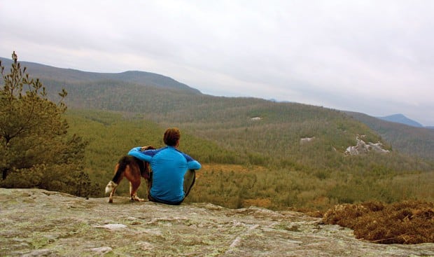
Park at the Cold Mountain Gap Trailhead on the east side of the valley. Pick up Panthertown Valley Trail (actually a gravel road) from the trailhead and head straight for your base camp, a sweet campsite at the junction of Powerline Road Trail, roughly 1.5 miles from your car. Here, you’re just a couple of hundred yards away from the Sandbar Pool, a unique sandbar in the middle of Panthertown Creek that makes for primo swimming and sunning. Set up camp and switch to a day pack with lunch and swim gear. Choose your route to Carlton’s Way, an unofficial piece of singletrack that twists through mountain laurel as it climbs the side of Blackrock Mountain. Top out at the sloping, granite overlook (4,200 feet) and soak in the all-encompassing view of Panthertown valley flanked by Big and Little Green Mountains in the distance.
After enjoying the view, take Powerline Road Trail to five spectacular waterfalls along the Tuckaseegee River. The sliding and swimming potential at waterfalls like Riding Ford and Red Butt is stellar, so block out a chunk of the afternoon for swimming shenanigans, then retrace your steps to the Powerline Road Trail, which you’ll take south back to your campsite.
Day Two
Hike east on Panthertown Valley Trail for a mile, then head south on Mac’s Gap Trail to Granny Burrell Falls. Next, climb steadily through a rhodo tunnel before summiting 4,200-foot Big Green Mountain. The summit is shrouded in hardwoods, but take the second man way on your right to a killer view from the top of “The Great Wall of Panthertown,” a 300-foot high granite face that stretches for nearly a mile. Carry on the Big Green Trail as you drop off the mountain, then go north on Mac’s Gap Trail for less than a mile to Little Green Trail.The trail hugs the edge of the mountain, moving along gray granite with veins of green moss and tiny potholes that hold water after a rain. Continue to follow the trail (faint white arrows painted on the rock) to your camp for the night, a flat spot inside a sheltered pine forest.
Day Three
Pack up and drop off the east side of Little Green Mountain on Little Green Trail, which ends at the base of Schoolhouse Falls.The swimming and photo potential at the bottom of this 25-foot waterfall is some of the best in the valley. If you have time and brought a fly rod, cross the river at the base of Schoolhouse Falls and take the man way upstream for great casting options and more solitude. Even if you don’t fish, this is a great side trip that will take you to Pothole Falls and Mac’s Falls. From Mac’s Falls, connect with Greenland Creek Trail for a quick jaunt back to the Cold Mountain Gap Trailhead and your car.
For an excellent tale of hiking and reviving ones sense of adventure, click here!


