Spanning 962 miles across North Carolina, the Mountains to Sea Trail (MST) includes the highest mountains east of the Rockies down to the lowest points along the Outer Banks. It traverses three national parks, three national forests, two wilderness areas, and the highest sand dune on the East Coast. And unlike other long-distance treks, biking, beach-combing, and ferry-hopping between islands are part of the trail experience.
Conceived in the late 1970s, the trail has taken shape over the last few decades to include a surprising mix of remote footpaths, suburban greenways, and back-road bicycle routes. Eventually, the MST will evolve into a footpath-only model, like most other long trails.
“Right now, there are 515 miles on the ground,” says Friends of the Mountains to Sea Trail executive director Kate Dixon. “There’s trail-building progress all over the state. And like the Appalachian Trail, it will never be finished. We’ll always be changing it.”
What will not change is the more accessible nature of the MST. More than 40 percent of North Carolinians live in counties through which the MST passes. Hikers spend almost as much time walking through and around towns as they do walking solo through the woods. And that’s the way trail planners want it.
“Even when the trail is complete, once you’re out of the mountains, the route will still take you through towns,” Dixon says. “That’s always been the plan.”
Of the handful of people to “thru-hike” the MST, some have taken a purist hiking approach, walking every step from Clingmans Dome in the Smokies to Jockey’s Ridge State Park along the coast. Others have chosen to tackle the trail with a mix of hiking, biking, and even hitchhiking. Where else in the country can you hike a nearly 1,000-mile trail that allows you to scale 6,000-foot peaks on foot, swim in the ocean, and pedal your bike across lonely back roads?
There and Back Again
Only 18 MST thru-hikes have been completed. Three of those belong to the same man: Scott “Taba” Ward, a 36-year old career hiker, who has also completed the only yo-yo hike, an out-and-back journey in 2009. Ward, who lives in a pickup truck he’s converted into a mobile apartment, has hiked a number of long trails—the A.T., Colorado Trail, and Vermont’s Long Trail—but the MST is closest to his heart. He recently published a detailed guide to thru-hiking the trail, The Thru-Hiker’s Manual for the Mountains to Sea Trail of North Carolina.
You live in a truck?
I have a mobile apartment in the back of a box truck. Two leather couches, carpet from the Embassy Suites, a hammock, a disco ball, six skate boards, two bikes, bike tools, backpacks.
What does your family think about your mobile life style?
Early on, they had some concerns, but now they see why I do it. I come from a circus family, the Flying Wards. They’re the trapeze artists with the Ringling Brothers. They’re known as the greatest aerialists of all time. I never learned trapeze, so I started jumping out of planes so I could officially be a Flying Ward. There are four things I never let keep me from traveling: Fear, because I don’t have any; money, because I don’t have any; a job; and a girlfriend. I can’t let somebody else tell me what to do with my life.
You don’t let money keep you from thru-hiking, but some people will spend thousands while tackling a long trail. How do you do it without cash?
I usually work my way through the trail. On the Colorado Trail, I only had $1 in my pocket when I started. Each time we’d come to a town, I’d get a day-job washing dishes. At the end of the day, they would give me $50, and I’d spend it all at the grocery store and head back on the trail with that same $1. Then I’d walk to the next town and do it again. You get to hang out with locals, drink mojitos at the bar. You’re a local for a night. I did this to some extent on the MST too.
You could have hiked any trail you wanted. What made you decide to hike the Mountains to Sea Trail?
I’d heard about the MST while living in Hawaii. I realized it wasn’t doable with the existing books because they didn’t list the water sources or legal camping options. My goal was to fix that. Thru-hikers need resources listed. I almost died five times on my first hike from dehydration and heat exhaustion. I even developed a kidney stone and had to leave the trail for a month. I walked around to all the churches along the trail finding water spigots, which I list in the guidebook. Then I asked if thru-hikers could camp on the church properties. Twenty churches said yes, and eight private residences said yes. All of those resources are now listed in the book.
The MST is still a work in progress and going through some growing pains with the camping issue. Are there any particular sections where the lack of legal camping is a real concern?
The Falls Lake Area [near Durham] is a real problem. There’s 22 miles of trail, and no legal camping. You can’t ask a thru-hiker to tackle 22 miles in a day in the middle of their thru-hike. I’m advocating for a thru-hiker’s permit to use pre-existing campsites. They’re already there; they’ve just been decommissioned. Why not let the handful of people who are walking across the state use them?
I understand you had a run-in with the law for trying to camp along the Parkway?
I wasn’t arrested or anything, I was just questioned. I was actually stopped 15 times by cops on my hike for standard I.D. checks—mostly in small towns where the residents didn’t even know the trail travels through their town. It got to the point where I’d just keep my head down and hope I didn’t get bothered by a cop. I don’t shave from the beginning to the end of the hike. It’s a tradition. So I have to fight the stereotype of vagrancy all the time.
Trouble with cops and a lack of camping, and yet you still love this trail?
Absolutely. It’s a phenomenal walk. You can have a blast. You see everything North Carolina has to offer—not just the woods like on the A.T. And the towns were amazing. 98 percent of the people I met were cool.
Which direction would you suggest that hikers travel the trail?
Walking from the beach to mountains is tough. Going from the mountains to the sea gives you a great finale. At the beach, you summit Jockey’s Ridge, then cross the street and jump in the ocean. It’s more rewarding.
What’s next for you?
I’m hoping to do something overseas. I’m bored. I’ve ridden my bike over 40,000 miles, I’ve walked over 6,000 miles. I’m looking for what’s next—maybe in another country. •
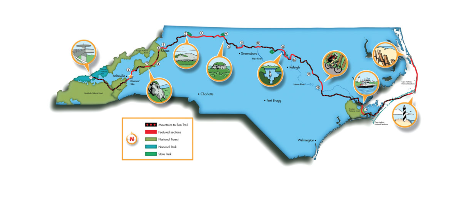
Mountains To Sea Trail Highlights
1. Clingman’s Dome
At 6,643 feet, it’s the highest mountain in the Great Smokies Mountain National Park, with views stretching for 100 miles on a clear day. “It’s a good feeling when you’re up there,” says Scott Ward.
Follow in the Footsteps of the President and First Lady
President Obama became the first Commander-in-Chief in modern history to go hiking. He and the First Lady vacationed in Asheville in April, and their first stop was the Mountains to Sea Trail. The Obamas hiked between Bull Gap and Craven Gap for about an hour. The 2.3-mile stretch is one of the flattest sections of the Mountains to Sea Trail in Western North Carolina. Park at either the Craven Gap or Ox Creek parking areas (mileposts 377.4 and 375.6 respectively) along the Blue Ridge Parkway to access the presidential stretch of the MST.
2. Craggy Gardens and Mount Mitchell
This 44-mile stretch from the Folk Art Center outside of Asheville to the north side of Mount Mitchell is one of the most spectacular. Craggy Gardens offers an entire mountaintop of blooming rhododendron in June—and panoramic views year-round. From there, it’s high-elevation ridge-walking to 6,684-foot Mount Mitchell. A short spur trail takes you to the Mitchell summit, the highest point east of the Rockies.
3. Linville Gorge
The MST drops down the west side of the gorge, taking hikers on a mandatory 50-yard ford of the Linville River. It then climbs up the eastern rim to Shortoff Mountain, The Chimneys and Table Rock Mountain for even more 360-degree vistas.
4. Beacon Heights
The 24-mile section of the MST between NC 181 and Beacon Heights on the Blue Ridge Parkway is the wettest, with 15 creek crossings. Check out Harper Creek Falls and North Harper Creek Falls, the biggest waterfalls along the trail.
5. Boone, N.C.
This trail town is Scott Ward’s favorite along the MST: “The attitude, the cool people. App State. I get stuck in that town for weeks at a time.”
6. Blowing Rock
Two trail crews are working on completing a 30-mile section of the MST between Blowing Rock and NC 16 along the Blue Ridge Parkway. This is the biggest unfinished gap in the mountains, and Friends of the MST expects to have 15 miles completed by October.
7. Stone Mountain
Take the 4.5-mile diversion on the Stone Mountain Loop, which summits the 600-foot granite dome and gives you a chance to play in a 200-foot waterfall.
8. Pilot Mountain
The MST follows the North Line Trace bike route from Stone Mountain State Park to Pilot Mountain State Park. For 43 miles, you’ll pedal low-traffic country roads, some of which have views of knobby Pilot Mountain in the foreground.
9. Hanging Rock
This 40-mile stretch rises 1,400 feet from the surrounding piedmont to Hanging Rock State Park, known for its sheer cliffs and massive rocky peaks. Hanging Rock and Pilot Mountain are connected via the Sauratown Trail, a 22-mile equestrian trail that cuts through privately owned forest and farmland. There’s no camping on this 22-mile stretch, but the Friends of the NCMST can arrange for a shuttle to campgrounds nearby.
10. Watershed Lakes
This 21-mile section of the MST connects six different footpaths around three lakes near Greensboro. Lake Higgins, Lake Brandt, and Lake Townsend were built to collect water from a 105-square-mile watershed. The MST hugs the lake district, cruising through a 750-foot-wide wooded buffer. The terrain is flat, the tread is smooth, and frequent road crossings and connector trails allow you to break this section into smaller pieces if you’re not up for the full 21.
11. World’s Largest Tea Pot
There is some dispute whether it’s a tea pot or a coffee pot. Decide for yourself in Stokesdale, N.C.
12. Haw River
Crews are working on a 70-mile multi-use trail along the Haw River. The Mountains to Sea will share half of that distance. Ten miles of trail are in place.
13. Falls Lake State Recreation Area
More than 50 miles of contiguous trail are now open along the shores of Falls Lake near Wake Forest thanks to the recent efforts of trail builders from the Triangle. The terrain is surprisingly diverse, moving from farmland to a hilly, hardwood forest. There are only two campsites along this stretch. Call the Friends of the Mountains To Sea for shuttle requests or camping options.
14. Neuse River Greenway
Raleigh’s mayor has repeatedly pledged to finish the 28-mile Neuse River Greenway, which is part of the MST, by 2012, which would get hikers off of county backroads and onto this paved, multi-use trail.
15. Buffalo Creek Greenway
This newly-minted greenway takes hikers along a three-mile multi-use path bordering the Neuse River and Buffalo Creek in downtown Smithfield.
16. Eureka
The 21 miles of the MST from Eureka to La Grange is entirely on back roads through scenic farm country. Bike this portion and knock it out in a fast, flat two hours.
17. The Neusiok Trail
The Mountains to Sea follows the Neusiok Trail for 20 miles through the underrated Croatan National Forest, which is a prime example of a coastal floodplain forest. Take a ferry across the Neuse River to kick this section off, then walk on dirt and wooden boardwalk through the swamp and loblolly pine forest.
18. Cape Hatteras National Seashore
The final stretch of the Mountains to Sea is predominantly a beach walk along the Cape Hatteras National Seashore. The 113-mile route meanders from one island to the next. There’s some road walking involved, as well as some coastal forest stretches, good camping, friendly towns, surfing, and ferry crossings. Hikers can climb the famous Cape Hatteras Lighthouse between April and October, tackling 248 stars on an iron, spiral staircase.
19. Jockey‘s Ridge State Park
The eastern terminus of the Mountains to Sea Trail is atop the tallest sand dune in the Eastern United States. After summitting the 140-foot dune, take a plunge in the Atlantic Ocean.


