The Soul Searching Backpacker
With all of these short day-hike options, you might think the Red has nothing to offer the “long walker,” but there’s plenty of opportunity to get deep into the woods for several days at a time. The Sheltowee Trace runs for 26 miles through the heart of the gorge, with dozens of loop hike options branching off in every direction. You could do a straight thru-hike of the Red’s portion of the Sheltowee as a long weekend, or walk for weeks connecting one trail after the other in big loops. But there are a couple of smarter options if you’re looking for weekend-long backpacking trips that offer a lot of bang for your buck.
- Swift Camp Creek Trail: The Red has its very own federally designated Wilderness, the 12,646-acre Clifty Wilderness, which spans a rugged suite of gorges, creeks, and cliffs that get a fraction of the attention that the rest of the area receives.
“I’ve found lost hikers in there twice,” says David Fisherman, a backpacker who’s been exploring the Red since the ‘70s. He spends most of his time bushwhacking in search of little-known arches, many of which sit inside Clifty. “They start out on a nature trail and end up deep inside the Clifty Wilderness. It’s a wild area. There’s a sign at one of the trailheads: ‘We guarantee neither your comfort nor your return.’ That says it all.”
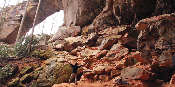
Hike the 6.5-mile Swift Camp Creek Trail to get into the heart of this lush forest packed with rhodo thickets, tall pine trees, and young healthy hemlocks. The trail hugs the side of the ridge 50 feet above the creek of the same name for much of the way. Short cliffs bank the wide, slow river, while taller cliffs reach toward the sky on either side of you. Swift Camp Creek Trail will give you the opportunity to bushwhack to see lesser known arches and outcroppings, but the trail also passes by a couple of highlights, like Pooch’s Falls, a 25-foot vertical drop over a cliff face with a hollowed out belly the color of rust.
Take your pick from primitive campsites as well as swimming holes with sandy beaches abutting sheer rock faces. You’re looking at a 13-mile out and back, but this is one trail you’ll want to hike in both directions as there’s so much to explore in this tiny rain forest.
- Rough Trail: The 8.6-mile Rough Trail begins off of Route 77 near the Nada Tunnel and cuts through the Red to Route 715, acting as a sort of spine for the intricate trail system. Take two cars for a shuttle, or knock this out as a 17-mile out and back. Either way, this route gives you the best opportunity to see the most arches in the gorge.
The only major feature you’ll pass on the trail is Gray’s Arch, which is worth it on its own, but you’ll have the opportunity for a side trip almost at every turn. Check out Military Wall, a massive cliff popular with climbers near Rough Trail’s western trailhead.
Then pop down the Daniel Boone Hut Trail to see the cave linked to the American Legend. With possible side trips to places like Pinch-em-Tight, Hanson’s Point, and 22 Windows. Your 17-mile weekend backpack could turn into a week-long exercise in speed hiking. Campsites are plentiful and so is water, so Rough Trail offers relatively care-free backpacking.


