 Timing is everything. It’s a cliché applicable to love, economics, and especially outdoor adventure.
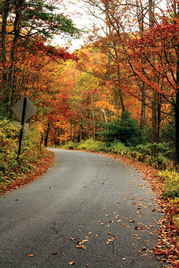
The importance of timing is probably never more relevant than during peak leaf season. For a couple of weeks every year, Mother Nature puts on a show—a last gasp before taking a long winter’s nap.
And make no mistake, Ma’ Nature is bragging during fall leaf season. She’s showing off. Luckily for us, she’s the most boastful here in the Southern Appalachians. Other mountain ranges may be taller, snowier, and rockier, but very few are as colorful during the fall.
Time it right, and you can find yourself in the middle of an epic Southern adventure while the mountains are transforming into a Technicolor dream right before your eyes. Here are a handful of adventures that are awesome any time of the year, but downright incendiary during peak leaf season.
THE FALL BACKPACKING TRIP
SHENANDOAH NATIONAL PARK
Big Meadows Campground, Virginia
It’s debatable about what elements the perfect fall foliage backpacking trip has to have. But one thing’s for certain: you have to have big views from a high summit. This two-night trip through the heart of Shenandoah National Park crosses the highest mountain in the park, offering a dramatic perch. Not enough to lure you into the backcountry? How about an optional rock scramble and an 80-foot waterfall?
Go in late October, early November for peak fall color, but be prepared to share the views. “You’ll see the most people in the park during foliage season,” says Howard Thompson, co-owner of Appalachian Outdoors Adventures in Luray. “But the views are outstanding.” Keep in mind, both campgrounds close mid-November.
Logistics
Trailhead: Hawksbill Gap (MP 45.6) on Skyline Drive to Lewis Mountain Campground (MP 57.5)
Total Mileage: 15 (not including side trips).
Outfitter: Appalachian Outdoors Adventures, Luray, Va.
Day one: five miles Start in Hawksbill Gap (milepost 45.6) and climb Lower Hawksbill Mountain Trail for one mile for the first killer view of the weekend. Hawksbill is the tallest mountain in the park, at 4,050 feet. The summit is rocky and has broad views from an observation platform. Take Lower Salamander Trail, which has more great views from rocky outcroppings, for .8 miles to the A.T. then head left on the A.T. for 3.4 miles to Big Meadows Campground. Grab a walk-in site which are first come, first serve. Explore the wide meadow, which sits at 3,500 feet, and if you have the energy, take a quick and easy side trip to Blackrock, a rocky knob with good views of the surrounding peaks.
Day two: ten miles From the Big Meadows campground, take the Lewis Falls Trail two miles to the 81-foot falls, then connect with the A.T., heading south for another eight miles toward Lewis Mountain Campground. Before you reach the campground, you’ll want to take the .3-mile side trip to Bearfence Rocks, a short, technical rock scramble to a bird’s eye perch at the top of a steep outcropping. It can be a bit hairy if you’re not used to scrambling, but the 360-degree view is outstanding. The short, technical hike is like a mini Old Rag, but without the crowds. Follow the A.T. south to Lewis Mountain Campground.
GREAT SMOKY MOUNTAINS NATIONAL PARK
Forget about hiking the Appalachian Trail in the Great Smoky Mountains National Park in October. You can do it, but you probably won’t find the solitude you’re looking for.
“The park is crazy busy on the weekends in October, especially on the Appalachian Trail,” says Vesna Plakanis, owner of A Walk in the Woods, which runs multi-day trips into the park during peak foliage season. “The A.T. is obviously spectacular, but there are some nice upper elevation areas off the A.T. that see far fewer crowds.”
Even with the crowds, it’s hard to beat the Smokies in October. With its miles of uninterrupted views in the midst of a color change, the peaks and valleys form a sort of kaleidoscope effect that’s hard to match. If you’re looking for that quintessential Smokies experience and need high elevations with long-range views littered with reds and yellows and oranges, Plakanis suggests looking to the ridgeline southeast of the A.T., where the less popular Benton Mackaye Trail runs along the crest.
“Over in the Cosby section of the park, you can get up high and avoid most of the crowds,” Plakanis says.
Check out this two-night trek that tops out just shy of 6,000 feet. It features a fire tower view before dropping into the Cataloochee Valley to peep some elk during prime rut season.
Logistics
Day One: 6.2 miles Hike the six-mile Baxter Creek Trail, which starts at the Big Creek Trailhead, but quickly begins climbing to the crest of 5,842-foot Mount Sterling. It can be a brutal climb, gaining more than 4,000 feet in six miles. The trail passes through a deciduous forest that should be in bloom mid to late October, and ends in a high-elevation evergreen ecosystem. At the top of the mountain, set up camp at Backcountry Campsite 38, then strike out for the Mount Sterling Fire Tower, a 60-foot perch built by the CCC in the ‘30s that offers 360-degree views. From the observation platform, you can see Cataloochee Valley to the south and Max Patch to the east. The mountain is just shy of 6,000 feet, so it receives less attention than other peaks in the park, but the view is just as impressive.
Day two: 5.5 miles Continue hiking southwest on Mount Sterling Ridge trail, which runs about a mile high in elevation, paralleling the Appalachian Trail on an opposing ridge. You’re actually hiking a piece of the Benton Mackaye Trail at this point. In 1.5 miles, head south on Pretty Hollow Gap Trail, which drops gently off the ridge following the creek of the same name. You’ll pass through pockets of old growth and remnants of mighty hemlocks. Pull up for the night at Backcountry Campsite 39.
Time it right, and you can drop into the valley after setting up camp at dusk and try to view some of the elk, which were reintroduced to the park in 2001. Cataloochee Valley is the hub of elk activity inside the Smokies, and October is their rut season, so there’s a good chance you’ll hear the distinctive elk bugle and maybe see some bull sparring.
Day three: 6 miles From the campsite, hike south on Pretty Hollow Gap Trail, continuing south as it joins Palmer Creek Trail for a short distance. Then head east on the Little Cataloochee Trail for five miles until it meets Cove Creek Road where your shuttle awaits. Your trek along the edge of the valley will take you under the canopy of huge poplars, but also by historic churches and cabins, remnants of the community that called the area home before the park was created.
Trailhead: Big Creek Trailhead, off exit 451 on Interstate 40 at the North Carolina/Tennessee border. You’ll need two cars. Note: You could create a smaller loop hike that wouldn’t require a shuttle by beginning and ending at Mount Sterling Gap, but you’d miss the hike up Baxter Creek Trail.
Mileage: 17-18, not including side hikes.
Outfitter: A Walk in the Woods offers guided hikes and backpacking trips. Mast General Store, in nearby Waynesville, has gear and provisions.
DAY HIKE
STONE MOUNTAIN WILDERNESS
Jefferson National Forest, Virginia
The 3,270-acre Stone Mountain Wilderness is one of Virginia’s newest Wilderness areas, designated in 2009. The south-facing rocky mountain is actually the northern edge of Cumberland Mountain, dominating the Virginia/Kentucky border. The 14-mile Stone Mountain Trail traverses the ridgeline from Roaring Branch to Cave Springs, passing by giant boulders and sheer cliffs that offer lots of exposure.
Most hikers enter the trail from Cave Springs, but the best portion of the Stone Mountain Trail lies on the other end. Hike a seven-mile out and back that begins at Roaring Branch, on the northeastern end of Stone Mountain, and you’ll cruise over boulders, around cliffs, and get the 360-degree view from High Butte. The hike begins with a mile of stone steps as you follow Roaring Branch up the mountain. The steep climb from the trailhead keeps a lot of would-be hikers away, so it’s likely you’ll have the rolling ridgeline all to yourself. Expect a few creek crossings, and if you go after a rain, keep an eye out for small waterfalls as you climb Stone Mountain. The highlight of the trip comes at 3.5 miles, where you’ll hit High Butte, which offers a big view of Powell River to the south and Black Mountain and Kentucky to the north.
Logistics
Trailhead: Roaring Branch, on Roaring Branch Road outside of Big Stone Gap, Va.
Total Mileage: 7
Outfitter: Nothing close.
PINNACLE MOUNTAIN FIRE TOWER
Unicoi, Tenn.
There was a time when fire towers stood proudly on tall peaks across the Southern Appalachians. But when spotting fires by air became cheaper in the 1960s, most land managers began systematically decommissioning the towers that once stood sentry over our forests. Today, only a fraction of the fire towers that once covered the mountains are still standing, and most of those are in such disrepair from decades of neglect, they’re unsafe to climb. The Pinnacle Mountain Fire Tower in the Cherokee Forest of East Tennessee was one of the worst offenders until the forest service and a local advocacy group spent $125,000 to completely renovate the structure, in hopes of turning the tower into a tourist destination.
Mission accomplished. The old tower was refurbished and a new observation platform was added, giving you a 360-degree panoramic view of the valley below and the surrounding mountains. From the tower’s perch on top of 3,520-foot Pinnacle Mountain, you can see the town of Unicoi below and the Unicoi and Unaka Mountains in the distance, which right about now should be set ablaze with red, yellow, and orange foliage.
Hike the brand new Pinnacle Mountain Trail, which climbs 1,500 feet up the mountain in a series of switchbacks over 4.5 miles, connecting the town of Unicoi to the newly revamped tower. It’s a nine-mile round trip, but the grade is manageable, and the tread is smooth and wide. The views don’t open up until you reach the top, so commit for the full hike.
Logistics
Trailhead: At the future site of the Tanasi Arts and Heritage Center, off I-26 at exit 32.
Mileage: Nine miles roundtrip to the tower and back.
Outfitter: Uncle Johnny’s in nearby Erwin has gear and local beta.

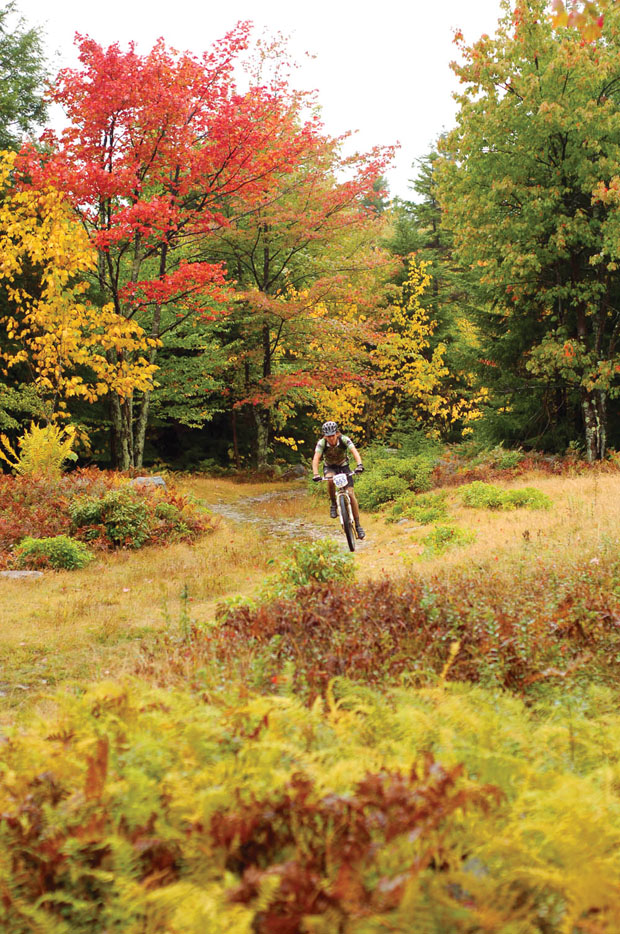

MOUNTAIN BIKE RIDE
PLANTATION TRAIL
Canaan Valley, W.Va.
There is no piece of singletrack in West Virginia more famous than Plantation Trail in Canaan Valley. The eight-mile long “ribbon of pain,” known for its continuous rock gardens interspersed with soupy bogs, has become synonymous with fat tire fun in the Mountain State. It’s a bucket list trail on every Southern mountain biker’s must-ride list.
“Everyone comes in asking to ride Plantation Trail,” says Van Morales, a local biker and mechanic at Blackwater Bikes in Davis. “But honestly, most people aren’t ready for Plantation. It’s become famous because it’s so consistently brutal from end to end. It’s fun, but only if you think rock gardens are fun.”
The truly hardcore will attempt to ride Plantation as a 16-mile out and back, which can be tough but rewarding, as the rolling trail has a completely different feel depending on the direction you take it. Most use Plantation as the highlight of a variety of loop rides. Either way, Plantation is a fat tire rite of passage. During fall, the trail will put you in the middle of a dense hardwood forest mixed with patches of red spruce. It’s eight miles of rock drops and rock hops. So be prepared to come out the other end tattered. Full suspension is a good idea. Disc brakes are a must.
Logistics
Trailhead: Well-marked on WV 32 south of Davis.
Mileage: 16 miles if you do the out and back.
Bike Shop: Blackwater Bikes, in downtown Davis.
JACKRABBIT TRAIL
Hayesville, N.C.
There may not be a more appropriately named trail system in the South than Jackrabbit, a 14.5-mile network of singletrack on the edge of Lake Chatuge that was built for riding bikes as fast as, well…a jackrabbit.
“We actually built it because we needed a place to take school kids to ride,” says Joanna Atkisson, president of the Southern Appalachian Bicycle Association, the group responsible for this purpose-built trail system. “But adults like to ride too. This is a system that provides that ‘yeehaw’ moment, whether you’re a kid or an adult.”
The stacked-loop system cruises through a peninsula jutting into Lake Chatuge on the North Carolina/Georgia border. The trails are packed with rolling dips, banked turns, and optional jumps and log rides. With no significant climbs and very few rocks and roots, Jackrabbit has become known as a flow-riding paradise.
“It’s the kind of system where you don’t have to worry about what’s around the next corner,” Atkisson says. “Good bikers can trust their instincts and glide through it, reaching top speeds.”
The majority of the trails meander through the woods, occasionally dipping down to the lake. The forest is full of sourwoods and maples that turn red and orange in the fall. For the best view of the lake, head to High Point trail, the most technical piece of singletrack in the system, with just over a mile of roots and a steep climb and descent. From the crest, you can see the lake below and the surrounding mountains in the distance. For the quintessential Jackrabbit experience, ride Burrell Cove, a 1.7-mile roller-coaster path packed with dirt jumps and tight, twisting turns.
Logistics
Trailhead: 4.7 miles east of Hayesville on US 64, then follow the signs to the Jackrabbbit Recreation Area.
Mileage: 14.5.
Bike Shop: SpinLite Cycles, in Blairsville, Ga. is the closest shop to Jackrabbit. Appalachian Outfitters in Murphy has lots of local knowledge as well.
![]()
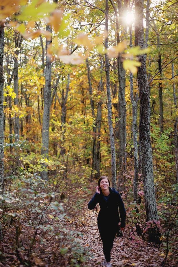
TRAIL RUN
EXPLORE PARK
Roanoke, Va.
A number of developers and land managers have had grand plans for Explore Park, an 11,000-acre county-owned forest outside of Roanoke. It has been operated mainly as a living history museum for the last several years, while being courted by developers as the home for the next great Southern amusement park. When the economy tanked, so did any grand plans for development—which is just fine for trail runners, hikers, and mountain bikers. While the living history museum may be closed because of budget concerns, the trails that traverse the forest are wide open.
The International Mountain Bike Association (IMBA) designated eight miles of singletrack inside the park, all of which can be accessed via the Blue Ridge Parkway just ten minutes from downtown Roanoke. Even though mountain bikers ride them, the well-maintainted system of trails is perfect for trail runners. The trails are scenic, fast, and fun.
“It’s an IMBA-designed trail system of flowy, twisty, turny trails that cut through the heart of this park,” says Josh Gilbert, owner of Mountain Junkies and maintainer of the Explore Park trail system. “There are some roots, but it’s not overtly technical or difficult.”
The system consists of interconnected loops (un-named) that create a generally fast and flowing trail run through a hardwood forest that comes alive every fall. The Intermediate Trail offers the most remote experience and the Expert Trail runs by the Roanoke River. Explore it on your own, or sign up for the Into the Darkness Night Trail Run (Oct. 22, mountainjunkies.net) for a seven-mile run that cruises along the Roanoke River and hits three miles of the park’s tight singletrack.
Logistics
Trailhead: Find Explore Park at milepost 115 on the Blue Ridge Parkway just outside of downtown Roanoke.
Mileage: The eight-mile system offers a number of loops and distances.
Running Shop: Fleet Feet Sports Roanoke.
DUPONT STATE RECREATIONAL FOREST
Brevard, N.C.
The 10,400-acre Dupont State Recreational Forest sits between the small towns of Hendersonville and Brevard, just across the valley from the mountains that comprise Pisgah National Forest. The two large tracts of public land aren’t more than 20 miles apart, but they couldn’t be more different. While Pisgah is steep and rugged, the mountains of Dupont are far more mellow and rolling. Where Pisgah has gnarly singletrack with waterbar drops and rock gardens, Dupont has more sustainable singletrack and devil-may-care fire roads. Point being, if you’re going for a long trail run during peak fall foliage season and you want to keep an eye on more than your feet, consider Dupont.
“It’s my favorite place to run,” says Lydia Odell, a runner and waterfall hiking guide who covers both Pisgah and Dupont. Odell likes the forest so much, she’s begun staging trail races in Dupont, including the brand new Dupont Forest 50K. “I like the rolling mountainside as opposed to Pisgah National Forest, where a typical run is two miles up, two miles down. You can run harder in Dupont. Plus it’s gorgeous.”
And more runners are adding Dupont to their favorites list, thanks to a new breed of running camps and trail races that utilize the forest’s mild fire roads and gorgeous singletrack. Set out for a 10-mile run in Dupont, and you can tick off riverside singletrack, massive waterfalls, and craggy domes before your legs start to quiver.
For lots of singletrack in a remote stretch of the forest, Odell suggests hooking up Jim Branch Trail with Ridgeline Trail for three miles of scenic running with good climbs. Dupont has 85 miles of trails and dirt roads, most of which are interconnecting, so those of you looking for longer runs are only limited by your imagination and lungs.
Logistics
Trailhead: The Lake Imaging trailhead sits off Staton Road in the middle of Jim Branch and Ridgeline.
Mileage: Three and up. Follow the Dupont Forest 50K course and you’ll knock out two 15-mile loops that traverse some of the most remote trails in the park.
Outfitter: Looking Glass Outfitters has the gear and local beta, just a few miles from Dupont’s entrance.
![]()
FLATWATER PADDLE
NEW RIVER
Pembroke, Va.
One of the few rivers in the country that flows north, the New is free flowing for 70 miles from Claytor Lake Dam into the Bluestone Reservoir in West Virginia. Much of this stretch of river is relatively mild as it passes through small mountain towns, offering a number of short slow-moving canoe trips that are becoming increasingly popular during the summer. During the fall, however, the New can get downright lonely.
“Our canoe rentals drop dramatically in October, but canoeing the New in the fall is phenomenal,” says Bill Wright, a guide with Tangent Outfitters in Pembroke. “The water’s higher, the fall foliage is amazing, there are no crowds, and with the leaves beginning to fall off the trees, you can see more of the rock formations on either side of the water.”
Arguably the most scenic stretch of the New runs between Eggleston and Pembroke, where the river runs between isolated high cliffs and rolling mountains with little development outside of the occasional fishing cabins and campgrounds. The seven-mile run also has a handful of straightforward class II rapids, easy enough for beginner paddlers to handle, but just exciting enough to keep things interesting. Shortly after you put in at Eggleston, keep an eye out for natural arches on the cliffs that tower above the river. Cliffs with pocket caves and natural arches continue to rise from the river as you move downstream, but your view is dominated predominantly by the multi-colored hardwoods that cover the slopes. Also keep an eye out for bald eagles, as a pair of nesting birds have taken up residence on the cliffs above this stretch of river.
Logistics
Put In: On Old Depot Street, outside of Eggleston.
Mileage: Seven.
Outfitter: Tangent Outfitters, in Pembroke, has canoe rentals, guided trips, and local beta.
LAKE JOCASSEE, S.C.
Lake Jocassee is probably most famous for its waterfalls, a handful of dramatic plunges that drop into tight, secluded coves in the corners of this man-made lake. Many of those waterfalls begin as narrow creeks, high on the “Blue Wall,” the steep escarpment that separates the piedmont from the mountains with some slopes rising 2,000 feet towards the sky. Paddle Jocassee during the fall, and it’s as if that “Blue Wall” that forms the backdrop to the lake has been tagged with graffiti…in a good way.
The 7,500-acre Lake Jocassee features 75 miles of largely undeveloped, mountainous shoreline. The Foothills Trail runs along the western edge of the lake, passing through arguably the wildest forest in the Upstate. The mountains surrounding the lake are primitive and remote, and the lake itself is just now being discovered as a world-class kayak destination. Know where you’re going, and you can spend days paddling Jocassee, exploring the lake’s maze of waterfalls, finger-like coves, and rock cliffs. If you know where you’re going.
“I think most people will paddle around Lake Jocassee all day long, get frustrated, and never see anything,” says Stacy Clark, owner of Get Outdoors, a new kayak guide company servicing the underused lake. Clark has begun taking clients on half-day and full-day treks, but plans to start offering multi-day excursions this fall. “In my opinion, Jocassee is the most beautiful place in the world. But it’s like the Louvre. You need more than one day to see it.”
But you can sample Jocassee’s goods in a day. For a quick trip, head to the three-tiered Wright’s Creek Falls. Put in at Devil’s Fork State Park (the only public boat access) and veer to the left across the main body of Jocassee into the Thompson River Branch of the lake. You’ll have to cross a couple of miles of choppy open water, but motorized boat traffic is pretty minimal, so the only trouble should be the wind. During low water, you can walk behind the falls and picnic on a “beach.” In high water, you can paddle behind the falls. If you want to keep exploring, continue to head toward the mouth of the Thompson River. The branch will narrow, and several small creeks will feed the lake via tight coves. In a couple of miles, you’ll hit the mouth of the Thompson, which meets the lake in a torrent of whitewater and rocks.
Logistics
Put-In/Take-Out: Devil’s Fork State Park has public boat access. Wright Creek Falls is to the left “across the pond.”
Mileage: It’s up to you. If you head to Wright Creek Falls and explore Thompson River Branch, you’re looking at 10 miles round trip.
Outfitter: Jocassee Outdoor Center has maps, rentals, shuttles, and kayak tours through Stacy Clark and Get Outdoors.
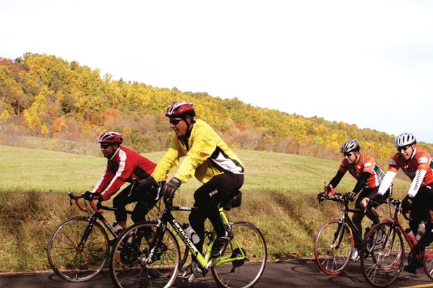
ROAD RIDE
CUMBERLAND, MD.
Cumberland could easily be considered the two-wheel hub of Maryland. Rocky Gap State Park just outside of town has primo singletrack, and two major rail trails meet in downtown (C&O Canal and the Great Allegheny Passage), giving the small town of 20,000 a thriving bike touring economy. Though road riding gets little attention with all of Cumberland’s trail options, the road routes that traverse the rolling hillside outside of town are absolutely divine, particularly during the fall leaf season.
The town of Cumberland is nestled in a bowl, so you’ll run into some hills no matter which direction you go. To maximize scenery and minimize opportunity for human error, follow the arrow cues laid out by the Western Maryland Wheelmen for their annual charity ride. The arrows are permanently painted on the streets, so you won’t have to worry about directions or complicated cue sheets, and the charity route heads east to take advantage of ridge climbs and natural scenery. You’ll have cues that lead you on 21-mile, 37-mile, 63-mile, or 100-mile ride options. Take the longer routes (the 63-mile ride has 4,750 feet of climbing) and you’ll cruise by two lakes, top out on two ridges, and have expansive views from high points along the roads.
“It’s incredibly scenic during the fall,” says Kurt Detwiler, a bike guidebook writer who calls Cumberland home. Detwiler says the route was actually designed to maximize fall foliage views, but the charity ride was moved to summer to take advantage of better weather. “The route goes through lots of woods with hardly any development, low traffic, great vistas. It can be cold during the fall, but the scenery is outstanding.”
Logistics
Trailhead: The ride begins at Canal Place in downtown Cumberland.
Mileage: 21 to 100, depending on your legs.
Bike Shop: Cumberland Trail Connection, in downtown, has all the info as well as bike rentals.
TOWNSEND, TENN.
There’s a good chance you’ve never heard of Townsend, Tennessee. Even though the small community of 300 sits on the border of Great Smoky Mountains National Park, the most popular national park in the country, Townsend sees only a fraction of the visitors that neighboring gateway towns see. The town has embraced its sleepy nature, branding itself as “the peaceful side of the Smokies,” and cyclists are beginning to embrace that sense of serenity as well, as they look for a quintessential Smokies road biking experience, without all the Smokies traffic.
“You can pedal rural roads for four hours and see only a few cars,” says Matt Alexander, an avid road cyclist and managing partner of Dancing Bear Lodge, an expansive lodge and restaurant that caters to bicyclists, hosting training camps and organized rides. “The roads are in great shape and the scenery is fantastic. And it’s East Tennessee, so there are no boring flats. There’s always a climb, downhill, or set of curves up ahead.”
The Foothills Parkway is the primo ride in the area. The 18-mile western section of the Parkway begins in Townsend and climbs Chilhowee Mountain to its peak at Look Rock offering views of the Smokies to the southeast and the Tennessee River Valley to the north. You can reach the same spot via one of three much shorter-but-steeper roads, which average 15 percent grades and max out with a brutal 30 percent grade climb.
“You feel like your kneecaps are going to fall off,” Alexander says, explaining that Blount County didn’t have road zoning laws until 2000, which is why the area has such steep grades.
Not up for the hurt? The Townsend Bicycle Trail is a nine-mile greenway that parallels the Little River, giving casual bikers an option for a mellow spin with plenty of foliage views and no climbing.
Logistics
Trailhead: Pick up the Foothills Parkway west of Townsend on US 321. The Townsend Bicycle Path runs through town and the Dancing Bear Lodge property.
Mileage: Nine miles for the greenway; optional to reach “The Top of the World,” which is what locals call the peak of the Foothills Parkway.
Bike Shop: Cycology Bicycles in Maryville, Tenn. is the closest shop to Dancing Bear and Townsend. The Dancing Bear Lodge is the epicenter for bike routes, rides, and post-ride grub.
WHITEWATER
YOUGHIOGHENY RIVER
Deep Creek Lake, Md.
The Upper Youghiogheny River in Maryland is one of the premiere class IV-V whitewater destinations in the Eastern U.S. Consistent releases from Deep Creek Lake feed the 10-mile stretch of water almost every Monday, Friday, and Saturday during the summer, making the Yough a warm-weather staple for Mid-Atlantic boaters and rafters. Unbeknownst to most, the dam releases continue into the middle of October, giving rafters five opportunities to paddle this adrenaline-pumping river in the midst of peak foliage season.
“The number of guided trips drops dramatically in October,” says Nancy Zbel, co-owner of Precision Rafting in Friendsville, Md. “But the river is gorgeous this time of year, with the leaves changing all around you. It’s one of the best rafting trips you can take.”
Obviously the temperature drops in October, so wetsuits are common on the river, but Zbel says it’s not as cold of a trip as you might think. “We have a lot of days in October when we’re on the water and it’s 70 degrees. Plus, the water releases from the top of Deep Creek Lake, so it’s been warming up all summer. It’s typically not that cold.”
The Upper Yough is a 10-mile trip that gets progressively more adventurous as you paddle downstream. You’ll start with 1.5 miles of easy ripples, move to a few miles of class III water, then the river hits its peak with four miles of non-stop class IV-V whitewater. When you’re in the mix of all that frothing water, it can be difficult to separate one rapid from the next. Run the river, however, and you’ll remember the big-water bliss of Charlie’s Choice, Triple Drop, and National Falls—three class IV-V rapids sandwiched on top of each other.
Looking for something more mellow? Try the Lower Yough, for class II-III+ rafting through the 20,000-acre Ohiopyle State Park in Pennsyvlania. The 7.5-mile Lower Yough runs year-round thanks to constant releases from the Yough Dam in Confluence, Pa., but guided trips tend to peter out late in October.
Logistics
Put-in/Take-out: Most outfitters operate in Friendsville, Md., the take out for the Upper Yough. The put-in is 10 miles upstream at Sang Run.
Mileage: 10. Outfitter: Precision Rafting, in Friendsville, is one of the most respected boat operations in the Mid-Atlantic.
Release Dates: There are five scheduled releases of the Upper Yough in October (1, 3, 7, 10, 14). The last day to paddle is the 14th, which happens to be peak foliage season most years.
OCOEE RIVER
Ocoee, Tenn.
While day hikers and car trippers flock to the high peaks during fall foliage season, the South’s rivers are left essentially abandoned. But the foliage view from the belly of a raft can be just as spectacular as the shot from a mountaintop. Consider this when planning your fall trip, because many of the South’s rivers enjoy recreational dam releases through October.
“It’s my favorite time on the river,” says Fletcher Haaga, a Tennessee boater and raft guide on the Ocoee River with the Ocoee Adventure Center. Like most rivers, the Ocoee’s visitation rises with the mercury as more adventurers flock to “America’s whitewater river” during summer break. “There are 20 companies on the river, so Saturdays in July get a little crowded,” Haaga says. “But in October, school is in session and most people aren’t thinking of rafting. The air may be a bit cooler, but the water temperature is the same. It’s dam released, so the water stays warm all the way through October.”
The water is so warm through October, Haaga says most clients don’t even bother with the wetsuits that the Ocoee Adventure Center provides. They raft the Ocoee in their shorts, just like summer. Only in October, they have one of the most popular whitewater destinations all to themselves.
The Middle Ocoee enjoys regular dam releases every weekend until October 30. It’s a five-mile, class III+ roadside run with nonstop whitewater. If the Ocoee is known for one thing, it’s big splashy waves, which you start hitting immediately after put-in. Double Trouble may be the most popular rapid on the river. It’s a fast collection of waves with two massive holes offering big splashes for rubber boats. The rapids tend to turn rafts into roving bounce houses.
The road follows the Middle Ocoee through the majority of the run, so it’s not the most remote whitewater destination in the South, but the gorge is steep, with mountain slopes rising on each side of the river. Couple the scenery with whitewater, and you’ve got the recipe for a killer fall trip.
Logistics
Put-In: Boats launch at the base of Dam #2 and run five miles to Dam #3.
Outfitter: The Ocoee Adventure Center runs trips on Saturdays and Sundays throughout October. Check out their outpost in Ducktown on US 64 a few miles from the put-in.


