The Trail Less Traveled, A Bartram Trail Guide
There’s a long trail that hits some of the South’s best ridge-top views. Nope, it’s not the A.T. It’s the B.T.
The Bartram Trail, a work in progress that runs for 110 miles through some of the loneliest and underrated terrain in North Georgia and Southwest North Carolina. “You’ll get a lot of solitude on this trail,” says Denise Davis, a Franklin-based ultra runner who trains on the Bartram and was the first to run it from end to end. “I can count on one hand the number of hikers I’ve seen on this trail over the years.”
start here
Most backpackers choose to hike the trail north, starting on the Chattooga River in Georgia, and tackling the toughest terrain in North Carolina after they have their trail legs under them. Forget the speed record (see below). The terrain is predominantly rocky and steep, so plan on a solid 10 days to take on the entire Bartram. Look for yellow blazes, diamonds in Georgia, rectangles in North Carolina.
trail highlights
Southern Terminus: Russell Bridge, over the Chattooga River, on Hwy. 28. In Georgia, the Bartram runs north through the Chattahoochee National Forest for 37 miles.
Ga. 0.9: Dick’s Creek Falls. A 60-foot plunge into the Chattooga River.
Ga. 19.8: Martin Creek Falls, a two-tiered 35-foot falls.
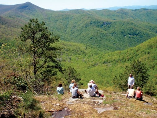
Ga. 22: Pinnacle Knob side trail. Take the short, but steep side trail to Pinnacle Knob, a rocky outcropping with views stretching into North Carolina.
Ga. 33: Rabun Bald is Georgia’s second highest peak at 4,696 feet. A CCC-era observation tower at the top offers 360-degree views. From the top of the bald, it’s four miles to the northern terminus, a hike that crosses 15 bridges on its way to the Ga./N.C. border, where the North Carolina Bartram Trail begins.
Ga. 37/N.C. 0: Georgia/North Carolina border.
N.C. 3.5: Osage Overlook. After crossing Highway 106, begin the monstrous 1,000-foot ascent of Scaly Mountain (4,804 feet) in 1.4 miles.
N.C. 5.5: Scaly Mountain. Peak out on Scaly Mountain and enjoy the long range views of Blue Valley.
N.C. 11: Jones Knob. Take the short side trail to Jones Knob, 4,622 feet, with views back toward Scaly Mountain.
N.C. 12.6: Whiterock Mountain. Follow the side trail for Whiterock Mountain for a year-round view of the rugged terrain to the south and west. You’ll also bag views as you navigate the ridgeline via the Bartram heading north.
N.C. 15: Wolf Rock, elevation 4,450, another big view in the Fishhawk Mountain Range.
N.C. 16.3: Random, abandoned school bus.
N.C. 20: Begin the 14-mile road walk between Buckeye Branch Road trailhead and Wallace Branch Trailhead.
N.C. 44: Wayah Bald. The trail high point, at 5,385 feet. A stone observation tower will get you even higher and provide a view of Franklin. You’ll cross the A.T. for the first time on the bald too (see Loop It). Enjoy the view, because you’ve got a brutal 7.5-mile descent down to Nantahala Lake with some sections so steep, you’ll need to use your hands for purchase.
N.C. 52: Nantahala Lake. You’ll skirt the edge of the highest lake in North Carolina (3,013 feet) during a half-mile road walk. You can also restock on gas-station food at Bateman’s Lakeside store.
N.C. 69: Winding Stairs. Begin the tough 3,000-foot climb over 5 miles from the Nantahala River up to the summit of Cheoah Bald.
N.C. 72: Bartram Falls. You’ll climb next to and through Ledbetter Creek, passing several small waterfalls on your way, including the two-tiered Bartram Falls.
N.C. Northern Terminus: Cheoah Bald, 5,062 feet. The grassy bald has a 360-degree view that includes the deep and dramatic Nantahala Gorge.
trail town: franklin, n.c.
Cherokee used to call the area of Franklin, “Nikwasi,” or “the center of activity,” thanks to the region’s importance in tribal mythology. Today, most people enjoy Franklin because it is the exact opposite of the center of activity. The Bartram runs through the heart of Franklin, making this small outpost (population 4,000) the perfect basecamp, or restocking point, for this under-appreciated long trail.
You can get a large pepperoni at Main Street Pizzeria (828-349-0979) for around $10. Outdoor 76 (outdoor76.com) has all the gear you could possibly need to make the second half of your Bartram thru-hike more comfortable than the first half.

loop it
We all dream of a major thru-hike like tackling the 110-mile Bartram, but logistical snafu’s, jobs, life…can get in the way. If you’re relegated to weekend-warrior status, have no worry. There are a few shorter loop options that use intersecting trails to give you the Bartram experience in a fraction of the time.
Cheoah-Wayah Loop: Heading north, the Bartram Trail meets the Appalachian Trail at Wayah Bald and again 30 miles later on top of Cheoah Bald. You can park at Wayah Bald and do a 50-mile loop by hiking north on the Bartram to Cheoah and heading south on the A.T. back to Wayah. You’ll bag big views from the tops of both balds, see Bartram Falls on the steep climb up Cheoah, and cruise along a series of 5,000-foot peaks while ridgehopping the A.T. back to your car. Bonus: You’ll pass through Wesser, home to the Nantahala Outdoor Center on the A.T. leg of the trip.
best day hike
Jones Gap to Whiterock Mountain, 4.5 miles, round trip
You’ll hike through the heart of the Fishhawk Mountains and bag the best vista in the Southern Appalachians, according to guide Burt Kornegay. “The overlook from Whiterock Mountain sits on top of a sheer rock wall. It’s like being on the prow of the Titanic, but you’re 2,000 feet above the ground,” Kornegay says.
fastest on the bartram
31:55 – Time (hours: minutes) that Matt Kirk ran the 110-mile Bartram in 2011.
3,000 – Number of calories Kirk consumed in the first 30 miles of trail between Cheoah and Wayah Balds, arguably the toughest portion of the trail.
Dozens – Estimated number of “naps” Kirk succumbed to while pushing through the Georgia portion of the trail.
the last piece of the puzzle
The Bartram Trail Society is currently building trail that will cut the current 14-mile road walk in half. A privately owned inholding within the Nantahala National Forest had kept the trail club from building the trail decades ago, but Burt Kornegay discovered that no owner had claimed the 13-acre parcel of land in 150 years. Twenty years ago, Kornegay filed a quick claim on the deed, then sold the land to the Bartram Trail Society for $1. The club recently handed the land over to the Forest Service and is now building trail.
“There are probably other parcels of land in the South that have gone unclaimed and nobody knows about them,” Kornegay says.
william who?
William Bartram was a botanist and explorer best known for walking approximately 2,400 miles over eight southern states between 1773 and 1776. He was looking for plants and probably discovered more new species in the biologically diverse Southeast than anyone else of his time. He also managed to document the Cherokee and wild landscape of the Southern Appalachians with a sense of respect and humanity that was unheard of for his time. Bartram may not be a household name today, but in the late 1700s, he enjoyed celebrity status, thanks in large part to his book, Travels, which documented his five-year exploration of the Southeast.
“This is one of the great American adventures,” says Burt Kornegay. “His book was one of the most widely published and most popular travel narratives of its time.”


