An insider’s guide to the gorges that provide the most colorful leaf-peeping adventures.
I’ve been away from the Blue Ridge mountains for a while. This autumn, I’m moving back, trading in the yellow aspens of Colorado for the color-filled palette of home. I’m looking forward to fall here, this season of change.
There is perhaps no place more dramatic for viewing the foliage of autumn than from a gorge, as waterfalls slip over banks and rivers rush between mountainsides brushed in orange, yellow, and red.
The juxtaposition of change, fast and slow, is appreciated in the gorge. Rocks and rivers that have run over eons, shaping one another, in harmony with the leaves that have lived a year, have changed, just for the season.
More than a fall drive, these regional gorges, all of which are also national or state parks, national rivers, nature conservancy preserve, and federally designated wilderness areas, also offer an array of recreation options. From ziplining and horseback riding to hiking and canoeing, opportunities abound.
Pack a picnic, raft, bike, running shoes, selfie stick, paddles, and head out! Peak foliage change is weather dependent, so check online or call parks directly.
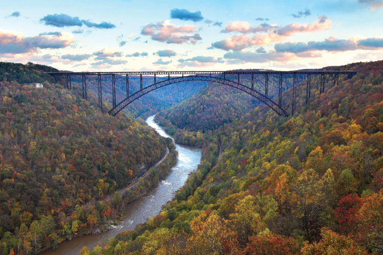
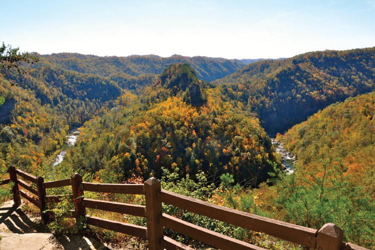
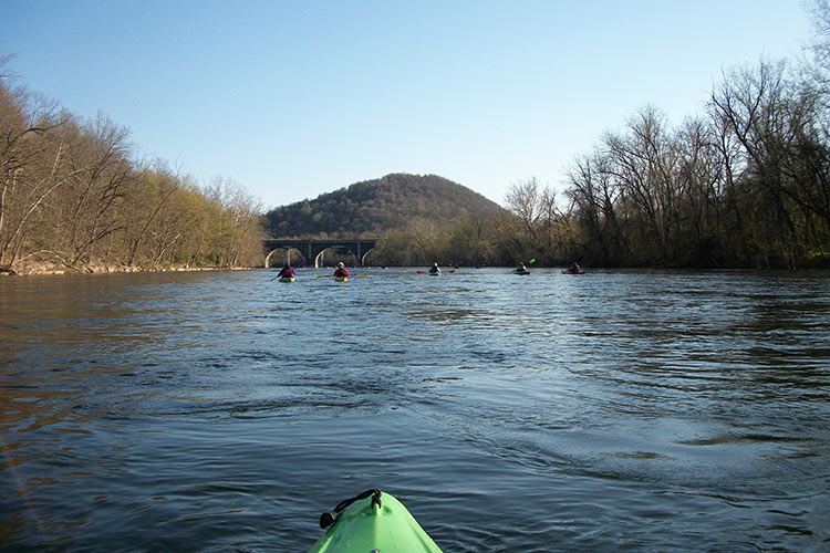
New River Gorge National River, W.Va.
“There will be a breeze. Because you’re so high up in the mountains here, there’s always a wind blowing,” says Mandy Wriston, Bridge Day Coordinator. “You’ll chill a little bit, wait for the sunshine, take a fresh breath of air when the wind comes through, smell on it the leaves that are starting to decay. That smell-you know it’s fall.”
On Bridge Day, held annually on the third Saturday of October, over 80,000 people descend upon New River Gorge, the bridge bouncing slightly under their weight. BASE jumpers in halloween-like costumes take flight, torpedoing through the gorge towards the New River, rushing 800+ feet below. Spectators lean over to snap shots.
“It’s all this color—the vendors, the BASE jumpers’ crazy outfits, and amid all of that, the foliage. The fall leaves frame the whole picture,” says Wriston.
Not into crowds? Most other fall days, seekers of solitude can find that here, too.
“It does not feel like a crowded park in most areas. I’ve worked in lots of parks, like Yellowstone and Grand Tetons, that get lots of people and you don’t get the access you do here. It’s a big enough park, people can spread themselves out,” says Public Affairs Officer for the park, Julena Campbell. Fall is one of her favorite times of the year.
Insider tip: The day after Bridge Day is the most visited day for the park. If you’re looking for a mix of fanfare and quiet, plan your trip a couple days leading up to and into Bridge Day.
Topography: The park spans 70,000 acres. The Gorge is the deepest and longest river gorge in the Appalachian Mountains. The New River, one of the oldest rivers on the continent, continues to carve the gorge among the largest remaining area of Mid-Atlantic forest in the world.
Peak viewing: Typically the 3rd and 4th weeks of October.
Recreation Opportunities: Biking, hiking, whitewater rafting, climbing, picnicking, camping, fishing, birding, canoeing.
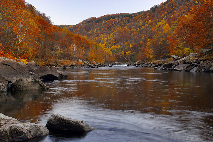
Gauley River National Recreation Area, W.Va.
High waters and class V+ rapids are a thrill that many whitewater adventurers seek. They find both at the Gauley.
The Gauley River runs 25 miles, through a series of breathtaking gorges and valleys. Many like to soak in the views from the water, especially in autumn, when water is high and the trees are at peak.
“Fall is known as Gauley season. The Dam on Summersville Lake is opened in the fall by the U.S. Army Corps and water comes tumbling out,” says Public Affairs Officer, Julena Campbell.
With the waters come the people. “Tens of thousands flock for the release of the dam the first couple of weeks of September,” says Campbell. The Gauley Festival ensues, 4 days of vendor booths and food.
It’s also a great location for fishing or passing a day, sitting on the riverbank.
“All of the typical eastern woodlands leaves are changing. The cooler temperatures are nice for hiking, picnicking and watching fall migration of birds,” says Campbell.
Peak Viewing: Third and fourth weeks of October.
Topography: The Gauley River, used by Native Americans for 10,000 years, runs 105 miles through the mountains of West Virginia, before merging with the New River. Together, they form the Kanawha River, a tributary of the Ohio River.
Recreation Opportunities: Fishing, camping, whitewater paddling.
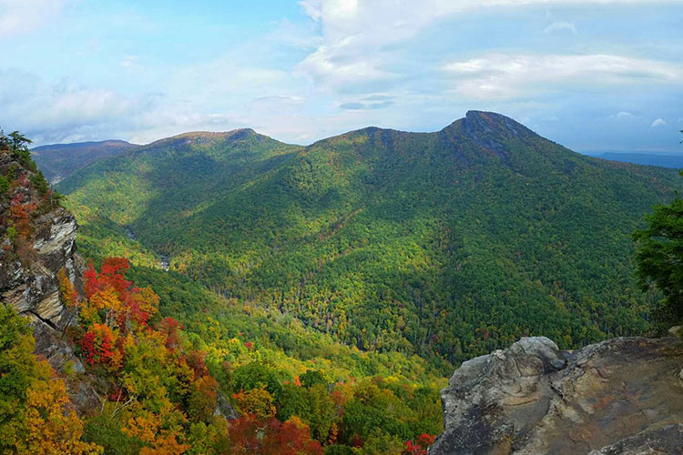
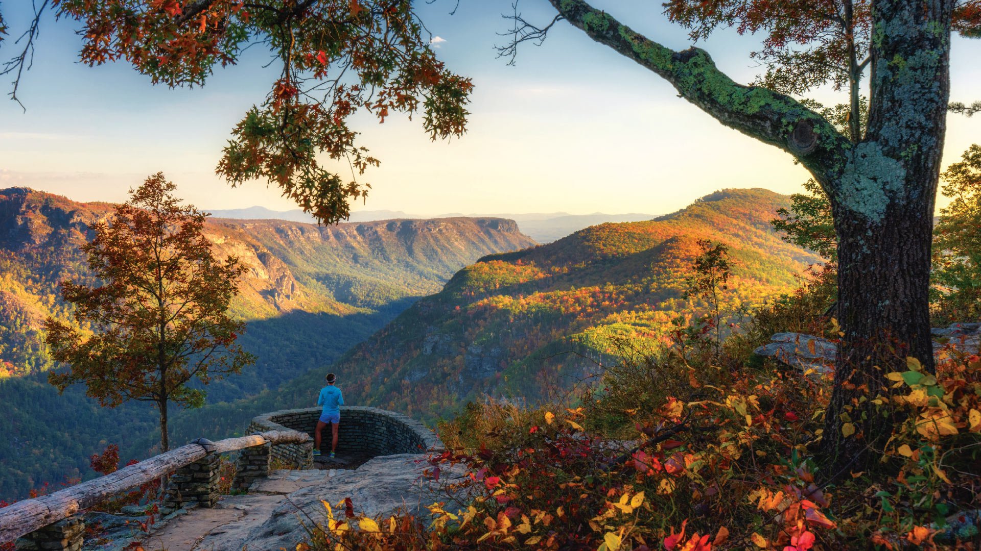
Linville Gorge Wilderness Area, N.C.
Hiking Linville takes grit. Trails are primitive and strenuous.
“People come to Linville to get away from it all. That’s the beauty of the wilderness area. It’s totally different from our everyday lives now. We can get away from cell phones. We can sit by a river, can sit on a mountaintop, can clear our minds,” says Lisa Jennings, Recreation Program Manager, with Grandfather Ranger District, Pisgah National Forest.
Elevation changes over 2,800 feet, from floor to highest point. This makes for a long viewing season. “You can see fall color creep from the top to the bottom, starting early October at the higher elevations on north end, and towards the beginning of November, in the lower elevations. It peaks at different times.”
One of Jennings’ favorite autumn hikes is Babel Tower trail. “It’s one of the less popular hikes. You go inside the gorge. Halfway down the gorge, you still have these really cool mid-range views, and an up close view of fall foliage.”
If you’re not up for a strenuous hike, Wiseman Overlook, located right outside the park (one exit south of Linville Falls entrance), provides views of the gorge, and also of Brown Mountain. Observations of strange lights, origin unknown, above Brown Mountain date back to Cherokee records. During the day, folks flock to the overlook for fall photos, and at night, to try to catch a glimpse of the lights.
Topography: The gorge is formed by the Linville River bisecting Jonas Ridge and Linville Mountain. The river drops 2,000 feet, spilling into the valleys below. View rugged terrain, with rock formations and waterfalls.
Peak viewing: Early October to early November.
Recreation Opportunities: Hiking, rock climbing, fishing, hunting, backpacking, camping, rock climbing, night sky photography, highlining.
The Breaks/Russell Fork Gorge, VA & Ky.
I’m working on this article, asking my 2.5 year old if she wants to go to the Breaks with me this Fall.
She’s enthustaitic about going, but also concerned.
“What’s broken?” she wants to know.
I explain.
She listens. Thinks. Starts moving. She’s got a plastic hammer in her hand, is looking for a wrench.
“I’m gonna take my toolbelt to fix the mountain,” she says.
Pine Mountain is the mountain she’s referring to, a mountain almost completely unbroken along its length until the Russell Fork River “breaks” through it by flowing through the gorge.
In the fall, visitors like to stand at State Line Overlook and take pictures of the two states-Kentucky and Virginia, side by side. The drive to the overlook provides some of the best fall foliage viewing in the park.
Elk, deer and black bears become more active around the park during this season.
One of the best ways to experience the park is by staying the night. “Screech owls call out into the evening. You might not see them, but you’ll hear them at night. Or, a lone coyote,” says Shay Wilson, Marketing and Interpretive Programs Coordinator. The park has over 100 campsites, primitive to full hook up, as well as yurts.
Another way to experience the colors is the Canyon Rim Zipline. Installed in 2017, the 2,000-foot long line whizzes visitors through the gorge, in a Fall blur of red, orange, and yellow.
“In October, many guests go whitewater rafting or kayaking on the Russell Fork River. From two of our overlooks, you can actually see the bright colors of the kayaks and whitewater rafts going down the river,” says Wilson.
Topography: The Breaks is the deepest gorge east of the Mississippi. Pine Mountain forms a 125-mile long border between Kentucky and Virginia.
Peak viewing: Weather dependent, but typically the 2nd and 3rd weeks of October
Recreation Opportunities: Twenty-five miles of hiking trails, whitewater rafting, ziplining, rock climbing, mountain biking, pedal boating and canoes, horseback riding, geocaching, birding, fishing.
Big South Fork National River and Recreation Area, Tenn., Ky.
Big South Fork contains the second largest number of natural sandstone arches in the National Park Service (only Arches National Park in Utah has more).
“There are 156 of them. They’re beautiful. If you’re in the Tennessee side of the park, and you want to check something out, go on the hike to see Twin Arches. It’s a beautiful walk, right under arches,” says Christopher Derman, Chief of Interpretation and Education for Big South Fork and Obed Wild and Scenic River.
“(Visitation) kicks up around the fall. People come because of the wide variety of foliage, the trees you can find here, in a wide kaleidoscope of colors, bright red of dogwood trees, yellows from maples and poplars, evergreen that stays green. There’s a wide variety of colors that makes it appealing to leaf peepers,” says Derman, using a name he fondly ascribes to fall visitors.
The park was established in 1974 to provide community access to recreation activities. “If you can name it, you pretty much can do it, hiking mountain biking, hunting, birdwatching,” Derman says, “to name a few.”
“Another great thing about Great South Fork is our visitation. We don’t get a lot of visitors like other parks, and that’s a big deal to visitors, who don’t want to go to a park and be bumping into people all the time. Here, you can be on trail and not see anyone else the whole time,” says Derman, who jokes that rangers from the Smokies come here for vacation.
Topography: Big South Fork comprises 125,000 acres of the Cumberland Plateau. The Big South Fork of the Cumberland River has, over eons, carved sandstone into cliffs, arches and chimneys, features visitors can observe throughout the park.
Peak viewing: Early to mid-October.
Recreation Opportunities: Camping, fishing, horseback riding, hiking, hunting, mountain biking, paddling, picnicking, ranger-led Night Sky and Astronomy programs, annual Haunting in the Hills Storytelling Festival.
Little River Canyon, Ala.
Little River runs most of its length atop Lookout Mountain. Reaching depths of over 600 feet at sections, it flows through waterfalls, rushing past changing trees.
Fall is beautiful here. “Oak, hickory maple and poplar are some of the dominant species. Depending on the weather, we get oranges, reds, some yellows, and if we have a good year, if we have a lot of moisture, the leaves hang on and they all get together,” says park ranger Larry Beane.
“Lots of years, there are two peaks. One, mid-October. Then if there’s a rain, it knocks off the first round, and the second week of November, there might be another peak,” says Beane.
The park boasts over 100 rare plants and animals, including several species of caddisflies that have only been located here.
“There are all kinds of beautiful flowers, and they bring the butterflies, and you can smell both the flowers and the leaves that are on the ground,” says Beane. Late summer/fall flowers include blazing star and coreopsis. “I like it when they’re all blooming—it’s a yellow and purple garden at some of the rock outcrops,” says Beane.
The canyon itself starts with a 45 foot waterfall, Little River Falls. The flow varies seasonally, from 3 feet to 150 feet across. Within a mile of the fall, the river is 100 feet deep. Little River runs through a series of bluffs, cliffs, and rapids.
Three waterfalls are located within the preserve: DeSoto Falls, Little River Falls, and the seasonally flowing Grace’s High Falls, Alabama’s highest waterfall, at 133 feet.
“It’s beautiful but it’s unforgiving. I encourage safety, every chance I get,” says Beane.
Topography: waterfalls, canyon rims, sandstone cliffs.
Peak viewing: Mid-October, and again, mid-November.
Recreation Opportunities: Hiking, fishing, playing in the river, picnic tables at most overlooks, hunting season in backcountry, horseback riding, educational programs at Canyon Center.
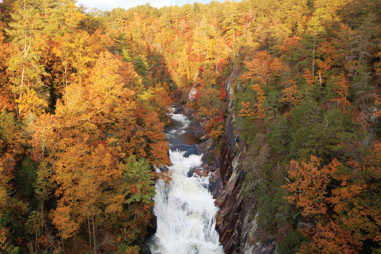
Tallulah Gorge State Park, Ga
Go early. Early risers can obtain permits to hike the gorge floor. It’s a tough but rewarding hike.
“You have to cross the river. It’s about knee deep moving water, with boulders that help you cross. You get wet on this hike. After that, you’re hiking downstream in the gorge. It’s all unmarked and primitive, flowing water, scrambling over boulders and fallen logs. After you hike ¾ of a mile, you get to Bridal Veil Falls, the only waterfall you can’t see from above,” says Interpretive Ranger for the park, Joell Zalatan.
The Interpretive Center issues 100 permits each day, except during water releases.
Even if you’re not an early bird, you can still get a bird’s eye view of the gorge. Hike a rim trail, or walk the park’s suspension bridge that sways 80 feet over the gorge, providing the sensation you’re walking across air (it’s been done; tightrope walkers have twice tiptoed across lines crossing the gorge).
Fall brings color to the gorge. “Poplars give us bright yellow, there are lots of maples, with those brighter red colors, sumac gives that deeper red, oaks gives us orange and yellows,” says Zalatan.
It is a place steeped in mystery and lore. “There are many stories and legends about Tallulah Gorge” says Zalatan.
She tells a story about the Nunnehi people. “This wild country was inhabited by a race of little men and women living in the crevices of the rocks and under the waterfalls. These little people lured the Cherokee into a cave in the side of Tallulah Gorge. The entrance to this cave was called the Happy Hunting Ground because those who entered were not heard from again.”
Topography: Tallulah Gorge, almost 1,000 feet deep, stretches for two miles, across the 2,689-acre park. Tallulah Falls is a one-mile series of waterfalls.
Peak viewing: Mid-October through mid-November. Insider Tip: Visitors can follow the GA State Parks Leaf Watch on Facebook to see how the colors are progressing and when the expected peak is.
Recreation Opportunities: Hike, kayak, picnic, ranger-led hikes, mountain bike, rock climbing. Check website for fall water release dates.
 Cloudland Canyon, Ga.
Stay late. Sunset hikes are a must. Park staff leads weekly hikes from the West Rim lot. “You walk up a service road, not a road people normally drive, you are sitting on a rock, at the top of the mountain, with an unobstructed view looking at the sun going down at the other side of Sand Mountain,” says Assistant Park Manager Woody Hughes.
Morning is beautiful, too.
“In the morning, especially in the fall, you are in the clouds here. You are able to stand in them, feel the cool air from the cloud, the moisture. The name fits. You can watch them roll out of the canyon. In the evening, they roll right back in. For the majority of the cooler months, you’re actually above them, you can see the clouds below you.”
Start the next day with a drive along West Rim road. Stop at Main Overlook for a pic and picnic. Then, hike a trail into the canyon via Waterfalls Trail, a 600+ stair trail, leading to Cherokee Falls and Hemlock Falls.
“In the fall, the leaves are changing as you’re going down into the canyon. Walking amongst them, you immerse yourself in the colors of the leaves on either side. As you’re going further down the stairs, more changes are apparent; it takes a little longer for those leaves at the bottom to change,” says Hughes, “You get to witness it from the top down. One day everything is green, the next everything’s changing color.”
Topography: Part of the Cumberland Plateau, Cloudland Canyon State Park is located on the western edge of Lookout Mountain. The gorge’s deep, sandstone and shale canyon walls are cut by Sitton Gulch Creek.
Peak viewing: Between October 1st and the second week of November.
Recreation Opportunities: Hiking, caving, disc golf, mountain biking, and horseback riding trails. Campsites, cabins. Also, fall brings some unique recreation opportunities to the park, including a Catfish Rodeo and hayrides.
Jack’s Narrows, Pa.
Float through fall. Two new community-owned river access projects on the Juniata River have opened up a section of the waterway to inner tubes, kayaks, canoes and rafts. The two launches, located at Mapleton and Mt. Union, bookend Jack’s Narrows, the deepest gorge in Pennsylvania.
This gentle stretch of the river flows for 3.3 miles, through the fall foliage growing up the steep banks of the gorge.
“Fall (and winter) are great times to visit to find peace and quiet. It’s never crowded,” says Ed Stoddard, Marketing Director for the Huntingdon County Visitors Bureau. He suggests a float and hike combo. “Our trails are always open.”
Thousand Steps (actually 1,200 stairs) is the most popular fall hike. In the 1930s, workers placed boulders up the mountainside to aid their commute to and from nearby rock quarries. Today, hikers and runners take to the stairs for a heart-pounding ascent to the top of Jacks Mountain.
“When you’ve done the hard work to get up there, climbed Thousand Steps, you get to the top, and you see the whole valley laid out before you, the fall color around you, you feel the crisp air, it’s just a special place on earth,” says Stoddard.
Topography: Deep gorge and water gap, cutting through sandstone.
Peak viewing: Late September into early October.
Recreation Opportunities: bike, hike, run, paddle, float, fish, hunt.
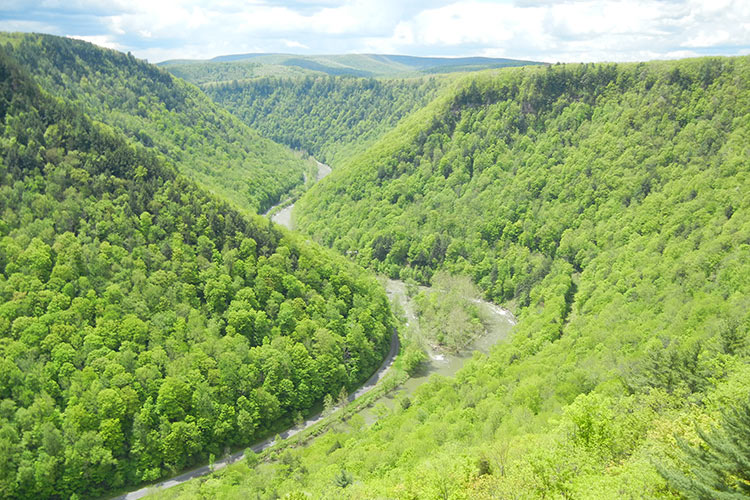
Pine Creek Gorge, PA
Pine Creek Gorge, viewed from lookouts within Tioga State Forest, is a rainbow of color in the Fall.
Autumn leaves tremble in the breeze, against a backdrop of canyon walls, themselves layers of gray, red, brown and green.
“I’ve been there on days, stopped at the lookouts, and the fog is so thick, it looks like you could walk out across it,” says Tom Oliver, Recreation Forester for the park.
“I would suggest checking out as many of the views as possible. Maybe even getting down into the canyon, by bike or from a hike from Leonard Harrison.”
Oliver suggests the Turkey Path. “It goes all the way from the top to the bottom, pretty much at the heart of the gorge. Once you’re down in there, and you can actually see just how high up the surrounding hillsides are, and the surrounding cliffs, it’s pretty remarkable.”
Historically, Native Americans used trails all around, but did not enter the gorge itself. There was superstition around the darkness of it. Now, between 30,000-40,000 visitors a year make their way to the canyon bottom to access Pine Creek Rail Trail.
Pine Creek Rail Trail is a converted railroad bed that weaves along the floor of the canyon for 62 miles, from Wellsboro Junction, to Jersey Shore, Pennsylvania. This highly popular, scenic trail is the perfect way to view fall colors.
“We almost have two fall foliage peaks,” says Oliver. “The northern hardwoods, maples, beech, birch, ash and cherries, those types of species change first. Mid-October to late October is the peak. Then, all the oak species after that will change. That’s usually the first or second week of November. “
Along the way, you’re likely to see beavers, white-tailed deer, turkeys, river otters, and bald eagles.
Insider tip: Two state parks, located on the northern end of the gorge, also provide great foliage viewing: Colton Point State Park to the west and Leonard Harrison State Park to the east.
Topography: Forty-seven-mile-long gorge, with walls composed of sandstone, siltstone, mudstone, and shale.
Peak viewing: Mid-October to mid-November.
Recreation Opportunities: hiking, biking, mountain biking, horse riding, picnicking, kayaking, fishing, hunting.
More Gorge-Ous Views
Mather Gorge, Maryland, is cut by the Potomac River. Hike Section A of the Billy Goat Trail; it follows the gorge from bellow Great Falls to Anglers Inn.
Bottom Creek Gorge, Virginia, a preserve maintained by the Nature Conservancy, has 5 miles of moderate trails, a lake, and the second highest waterfall in the VA. Also known for rare aquatic species.
Bald River Gorge Wilderness, Tennessee, comprises 3,791 acres of Cherokee National Forest. Bald River is a small, wild trout stream. It’s a great location for fishing, hiking, picnicking.


