Citizens Can Play a Key Role in Improving the Health of Streams
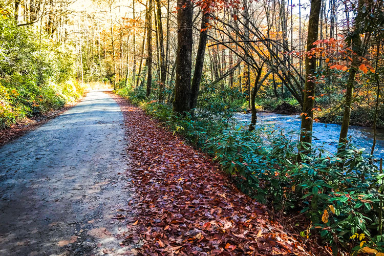
Many of us are called outdoors by the sound of rushing water. In Southern Appalachia, there is no shortage of clear, flowing streams back-dropped by the beautiful hardwood forests and rolling mountains that define our region.
We’ve all noticed these same streams rushing rapidly after a hard rain, now characterized by a light brown cloudy appearance caused by soil erosion. After several dry days, the water regains its typical character, yet the questions still exist: where did all that soil come from, what are the impacts, and how can I help?
Nick Holshouser, a local in the Brevard area, has had success in contacting various organizations regarding sedimentation from a logging operation in Pisgah National Forest. “You could clearly see brown water flowing off the site and into the river. Just above that, the North Fork was running clear.” Holshouser contacted the Southern Environmental Law Center, who then contacted the U.S. Forest Service.
He also posted pictures to social media which were picked up and featured in a story by the Transylvania Times. “From there, the Forest Service reached out to me, and I went to the site with them several times. I continued monitoring throughout the logging, and they continued to address my concerns.”
The Dirt on Sedimentation
Soil enters our waterways through a process called sedimentation. It isn’t well-known, but sedimentation is the primary water pollutant in our region. The main source of sedimentation in the clear streams of Western North Carolina’s National Forests is gravel roads managed by the United States Forest Service (USFS).
Many of these roads, which in total stretch 380,000 miles nationally, are the gateway into some of our favorite natural areas. The proximity of these roads to streams, paired with damaged culverts, causes excess soil to enter our water.
This is bad news for wildlife in the streams. By reducing sunlight and clouding up the water, sedimentation disrupts the aquatic food web. Plants are unable to photosynthesize, while insect, fish and amphibian eggs are smothered. Many fish, including our native brook trout, can’t find food in the murky waters.
In short, the impacts of sedimentation are felt throughout the aquatic food web and cause some of the most treasured species in our region to suffer.
Then there’s the cost of filtering muddy water. Many of these streams are sources of drinking water in towns throughout Western North Carolina. For example, Catheys Creek in Pisgah Forest is the sole water source for Brevard. Sediment that enters this creek from nearby Forest Service roads requires additional filtration at the treatment plant before it is safe for consumption. These increased costs at water treatment facilities are paid for by state taxes. As a result, we find ourselves paying for the impacts of sedimentation in more ways than one.
The Forest Service’s role
Scientists and engineers in our area have known that forest roads are a major source of sedimentation for almost a century. Since the Coweeta Hydrologic Laboratory in Otto, NC, was established in 1934, experts have been conducting research to assess the impacts of these roads on local streams. In 2018, a ten-year assessment was released on the condition of logging roads in Croatan, Uwharrie, Pisgah, and Nantahala National Forests.
The report, conducted by North Carolina Forest Hydrologists Brady Dodd and Dick Jones, concluded that 97% of the USFS practices resulted in streams with no visible sediment. While demonstrating promise that the USFS is effectively mitigating many potential sources of stream sedimentation during logging operations, logging roads make up only a portion of the total USFS roads and are not used by the public.
Holshouser’s story also indicates that while the USFS works hard to prevent sedimentation issues, instances occur where a single site can have a large impact. Although the USFS has drastically increased the amount of recreational areas in recent decades, logging has historically been their focus and its impacts continue to be more well monitored and studied.
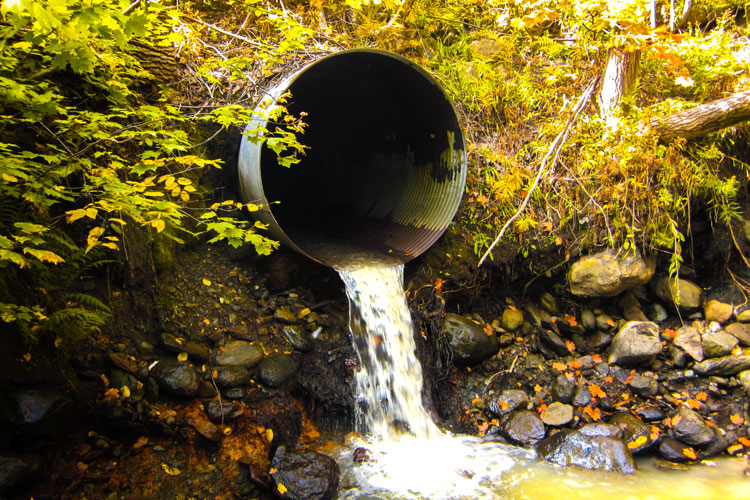
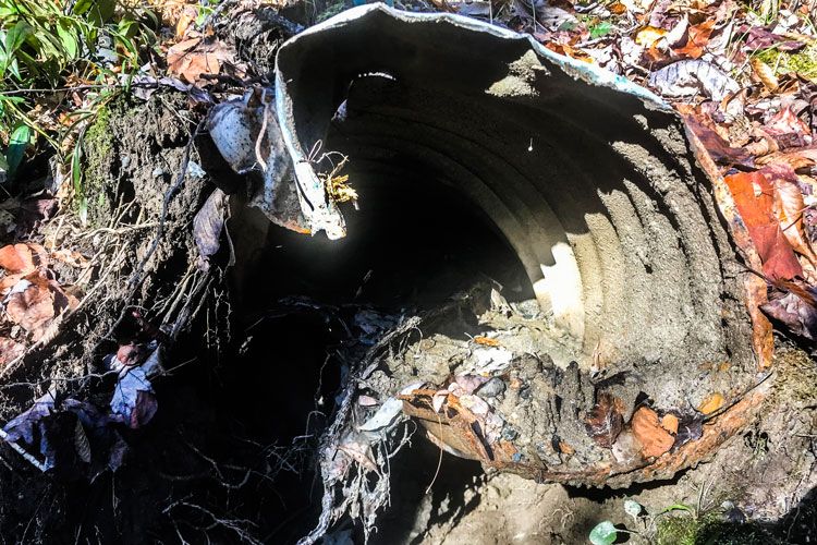
As for recreational access roads that outdoor enthusiasts frequently find themselves on, regular inspections occur. Barry Jones, the Engineering Staff Officer with the National Forests in North Carolina states, “major culverts and bridges are on an inspection cycle every two years”. However, much damage can occur to road infrastructure between inspections. Culverts can become clogged with debris and soil in a matter of days if the conditions are right.
Some culverts are so damaged or buried that they can be overlooked during
What YOU Can Do
When you’re driving to your next adventure, take a moment to notice potential sources of sedimentation and the condition of your favorite streams. Sedimentation issues are a priority for the Forest Service, and reporting this information can be the difference between thousands of pounds of soil entering our waterways or effectively conserving our aquatic natural resources. As travelers on gravel roads nearly every time we venture into the forest, we can serve as the eyes and ears for the USFS through these simple actions.
- Think like a scientist. Collect information as you travel along forest roads that will help inform the proper authorities of what you notice. Take GPS coordinates with your smart phone and write notes so the responders have the right equipment to fix the issue. Document what you see with photographs.
- Send the information you collect to multiple authorities. Sometimes federal or state agencies can be slow to respond. When you notice an erosion issue on a USFS road, you can contact local environmental organizations such as MountainTrue, the Forest Keepers Alliance, the Southern Environmental Law Center, Trout Unlimited, or Conserving Carolina in addition to the appropriate Ranger District.
- Consider bringing a “tool kit” along when you hike, bike, climb, or fish. This can include a small shovel, a handsaw, and flags. The shovel and handsaw can be used to clear built up soil, leaves, and other large debris from the entrance of a blocked culvert. The flags are useful to mark the location of a damaged culvert or other potential issues so that the responding authority knows the location of the site.


