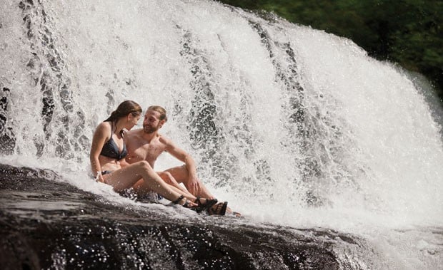
Photo: Steven McBride
Ah, August in the South. Temps in the 90s, humidity off the charts, kids frying eggs on the sidewalk for the local news team…you need to cool down. You could beat the heat the old-fashioned way and fill up a plastic kiddie pool in your front yard, or you could set out for one of these pristine swimming holes scattered throughout the Southern Appalachians.
BIG BEND SOUTH BRANCH OF THE POTOMAC, W.VA.
Highlights: Solitude, tubing, family- friendly
Deep inside the wild Monongahela National Forest, the South Branch of the Potomac makes a drastic U-turn through the scenic Smoke Hole Canyon. Green forested gorge walls are interspersed with rocky cliffs on the outer edge of the “big bend” in this river, while a forested campground occupies the inside peninsula. The entire loop around the campground is a mile long, packed with small riffles and fun waves, perfect for running laps in a tube on a hot summer day. Tube for an hour, walk a few hundred yards across the peninsula, and start again. This is primitive tubing at its finest, so bring your own tube, and don’t expect heavy crowds, even on a summer weekend.
Nearby: The 24-mile long North Rim Trail follows the western rim of Suck Hole canyon. It’s a primo mountain biking and hiking trail with rocky outcroppings and a cornucopia of long-range views.
Closest Town: Petersburg, W.Va.
Directions: Follow US Route 220 from Petersburg to the Upper Tract Bridge at County Route 2. Take a right at the bridge and follow County Route 2 for 10 miles into the campground.
MEADOW RUN YOUGHIOGHENY, PA.
Highlights: Natural water slide
There are natural water slides, and then there’s the waterslide on Meadow Run inside Ohiopyle State Park. Just before Meadow Run meets the Youghiogheny, the creek funnels through an expansive stretch of bedrock, wearing down a smooth, narrow chute in the process. The slide-able section is at least 100 feet long with a couple of twists along the way. Go during high water, and it’s a fast-paced thrill ride that demands repeat performances. But remember the rules of friction. Even a smooth rock waterslide will wear your shorts thin after a while. Go like a local: wear denim.
Nearby: Tackle a piece of the 70-mile Laurel Highlands Hiking Trail. The 6.3-mile section of the trail that traverses the center of Ohiopyle State Park is rocky, strenuous, but packed with views and creeks.
Closest Town: Ohiopyle, Pa.
Directions: The closest trailhead to the water slides is where State Road 2019 meets Highway 381.
Watch video of what could be the Mid-Atlantic’s greatest natural waterslide.
HUNGRY MOTHER LAKE HUNGRY MOTHER STATE PARK, VA.
Highlights: Family-friendly, scenic
The story of Hungry Mother’s name may be a bummer (a village raided, a boy lost, and a mother dying of starvation), but its present-day incarnation couldn’t be more uplifting. The calm waters of the 108-acre lake, which is surrounded by lush green slopes, have become a haven for flat-water canoeists and swimmers. The lake is a huge hit with families during the summer thanks to the man-made beach. If you’re looking for something a little more tranquil, rent a canoe from the park or hike the 5.7-mile Lake Loop trail to one of the more secluded coves recessed into the forested banks. Gas-powered boats aren’t allowed on Hungry Mother, so the deepest pockets of the lake are less crowded. This year marks the 75th anniversary of Hungry Mother State Park, Virginia’s first state park.
Nearby: The 2,000-acre park has 12 miles of trail. Check out the 1.6-mile Molly’s Knob Trail (named after the hungry mother) that ascends to the park’s highest point at 3,270 feet.
Closest Town: Marion, Va.
Directions: Take exit 47 from I-81, then follow Route 11 for one mile toward Marion. Turn right on Route 16 north and go four miles to the park.

FRIDLEY GAP HOLE FRIDLEY RUN, VA.
Highlights: Solitude, tranquility
Forget about cliff jumps and natural waterslides. At Fridley Gap, you’ll find something that’s even more rare: solitude and tranquility. The small plunge pool is situated at the base of a tiny cascade, all of which is surrounded by medium sized boulders and smaller rocks. The swimming hole isn’t going to make the cover of a magazine, but it’s cold, refreshing, and stuck in the middle of the Massanutten trail system, some of the best hiking in the George Washington National Forest. The pool is typically six feet deep and three times as wide, with crystal clear water that would probably be a hot spot for trout if you weren’t splashing around. The fastest hike to the swimming hole is to pick up Fridley Gap trail from the parking area at the end of Airey Lane. In less than a mile, you’ll find yourself at the swimming hole. But you’d be remiss if you didn’t take the time to explore the trail system that branches off of Massanutten South Trail while you’re in the area.
Nearby: Make a loop out of the Massanutten South Trail and the Fridley Gap Trail for 3,000 feet of elevation gain. You’ll traverse the Third and Fourth Mountains and cross more wild creeks.
Closest Town: Shenandoah, Va.
Directions: From Shenandoah take Route 602 for four miles and turn on Runckles Gap Road. Drive two miles to Cub Run Road. Drive 1.5 miles on this gravel forest road to Fridley Gap Trailhead.
ROSE RIVER FALLS SHENANDOAH NATIONAL PARK, VA.
Highlight: Scenery, bushwhack potential
The 67-foot Rose River Falls drops in two tiers as it makes its way off the ridgeline below Skyline Drive. The falls can be just a trickle late in the summer, with a small stream of water carving through a narrow crack in the rock wall. But go after a rain and the water spills over the rocky ledge via a suite of streams, all of which meet in the blue-green pool at the bottom of the rock wall. The pool is only a couple of feet deep, so forget about jumping. But the multi-layered waterfall, rock ledge, and lush foliage give the entire scene a rain-forest vibe. It can be a popular destination, but if it gets too crowded, start bushwhacking upstream. The going is slow and the vegetation is thick, but you’ll find big pools in total seclusion.
Nearby: Biking the 60-mile Skyline Drive is a legitimate way to work up a sweat before cooling off in this swimming hole tucked inside a mini rain forest. If you’re in the park after a rain, check out the impressive Lewis Falls, accessed from the Big Meadows Area.
Closest Town: Syria, Va.
Directions: Park at Fishers Gap Overlook on Skyline Drive at mile 49.4. Take the Rose River Loop Trail counter-clockwise for the quickest trip to the falls. Complete the four-mile loop and you’ll take in Dark Hollow Falls as well.
BAD BRANCH FALLS PINE MOUNTAIN, KY.
Highlight: Scenery
The wild Bad Branch River drops dramatically off the southern face of Pine Mountain, a 110-mile ridgeline that helps define the southeastern edge of Kentucky. The river makes its most dramatic statement as it plummets 60 feet over a sheer wall of sandstone. The waterfall created by that drop, Bad Branch Falls, is the centerpiece of the Bad Branch Falls State Nature Preserve, and it’s a welcome sight to anyone who’s been hiking along the rugged Pine Mountain in Eastern Kentucky. Massive boulders and tall hemlocks dominate the floor of the gorge at the base of the waterfall. There isn’t much of a pool for swimming at the bottom of the falls, but if you’re careful, you can maneuver your way beneath the dramatic waterfall and get soaked while hugging the cliff face. After hiking the rugged nature preserve, it’s bound to be one of the most refreshing showers you’ll ever take.
Nearby: Hike a piece of the completed Highlands Section of the Pine Mountain Trail, a long trail in the making that will eventually stretch the full 110 miles of Pine Mountain, connecting Breaks Interstate Park with Cumberland Gap National Historic Park. Check out the High Rock Loop, from the nature preserve, to reach the highest point on the mountain.
Nearest Town: Whitesburg, Ky.
Directions: From Whitesburg, follow 119 south for eight miles. Turn left on KY 932 and go east for two miles to the gravel parking area.
LAKE WINFIELD SCOTT COOPERS CREEK, GA.
Highlights: Family-friendly, scenic
You might feel like you’re back at summer camp when you first take a dip in this 18-acre lake at the headwaters of Cooper’s Creek in North Georgia’s Chattahoochee National Forest. The calm, cool waters are surrounded by mountains with a steep, forested shoreline, offering a remote scene straight out of your favorite childhood memories. The Appalachian Trail is close, and two connector trails begin at the lake. There’s a small beach with a designated swimming area complete with a dock to round out your summer camp memories. The crowds are minimal, but there’s a half-mile trail that hugs the lake if you’re looking for more solitude.
Nearby: Hike the Slaughter Creek Trail for 2.7 miles from the lake to its junction with the Appalachian Trail. You can combine a piece of the A.T. with Jarrad Gap Trail for an eight-mile loop that begins and ends at the lake.
Closest Town: Blairsville, Ga.
Directions: From Blairsville, take US 19/129 south for 10 miles. Turn west on Highway 180 for seven miles, to the recreation area.
CATHEDRAL FALLS LINVILLE RIVER, NC.
Highlights: Scenery, rock jump, solitude
Many kayakers consider the class V Cathedral Falls the highlight of their wilderness paddle down the unpredictable Linville River. Upstream of the falls, the entire river narrows to half its size as it cuts a path through the rock walls of the Cathedral Gorge. The river opens again after the final drop, a 15-footer surrounded by steep rock walls. That’s where one of the most perfect swimming holes lies. The falls may be a blast for kayakers after a heavy rain, but visit in late summer during low water, and it’s an ideal spot for a lazy day of swimming. The pool is deep, the scenery is outstanding, and there are a number of rock jumps ranging in heights. There are even smooth, broad rocks for sunning. And you’re deep in the belly of one of the wildest, most remote gorges in the South, so don’t expect crowds.
Nearby: You’ve got several miles of hiking along Spence Ridge Trail and the Linville Gorge Trail just to access Cathedral Falls and get back to your car. If that’s not enough, keep going south on the Linville Gorge Trail, which follows the river into the most remote stretch of the gorge, accessing countless more swimming holes in the process.
Closest Town: Linville, N.C.
Directions: From Linville, take Highway 181 south for three miles to FS 210 (Gingercake Road). Stay to the left when the road forks and follow the gravel road to the Spence Ridge Trailhead parking.
BLUE HOLE MILL CREEK, TN.
Highlights: Scenery, cliff jump
Blue Hole is the biggest and deepest swimming hole in a series of cascades and pools on Mill Creek. The small stream makes its way down Holston Mountain to Stony Creek in Cherokee National Forest. The water cuts through a small rock gorge, dropping 70 feet over a series of four distinct drops, all within a few feet of each other. The deepest pool comes after the third drop, where the creek falls 15 feet into a round, carved out pool that sits on a plateau before dropping one last time. “Blue Hole” could be the most common name for Southern swimming holes, but this one earns its moniker, as the water is clear blue. The pool is deep in the center, and there’s a popular cliff jump, but be sure to scout ledges beneath the surface first. Try to time it after a rain and the swimming hole will be filled to the brim, spilling over that last drop. Blue Hole may have the best swimming, but check out the upper two falls as well.
Nearby: Check out Laurel Fork Falls via a 2.5-mile spur trail off the Appalachian Trail that goes deep into the Pond Mountain Wilderness Area.
Closest Town: Elizabethton, Tenn.
Directions: Take Route 91 east from Elizabethton for 10 miles. Turn left on Panhandle Road and park at the pulloff one mile in. Take Blue Hole Falls Trail for a couple hundred yards to the gorge.
OCONALUFTEE RIVER CHEROKEE, NC.
Highlights: Tubing, family friendly
The Oconaluftee River begins as a mountainside spring in the Great Smoky Mountains National Park, but by the time it reaches the town of Cherokee, it’s a broad, pristine playground ripe with trout, swimming holes, and tubing. Check out the two-mile trip that begins at the Big Cove Bridge on the tail end of the Raven Fork River and ends just before reaching the town of Cherokee. You’ll float under the Blue Ridge Parkway, bump through small rapids, and have access to The Beach, a local hangout with a sandy river bottom and rope swing. This stretch of river is banked by Great Smoky Mountains National Park on one side and the Cherokee Reservation on the other, so development is minimal. Tubers have even been known to see elk drinking from the river. If you’re looking to test your extreme tubing skills, ask Cherokee Rapids to take you to the class II chute on the Raven Fork just above the typical put-in.
Nearby: You’re in the Smokies, so hiking trails stretch in every direction. Check out the Smokemont Loop Trail for a six-mile loop hike through a historic community that thrived before the park was established.
Closest Town: Cherokee, N.C.
Directions: Cherokee Rapids (cherokeerapids.com) is located off of Highway 441 in Saunooke Village.
RED BUTT FALLS TUCKASEGEE RIVER, NC.
Highlights: Slide, solitude
Inside the wild Panthertown Valley, in North Carolina’s Nantahala National Forest, the upper Tuckasegee River is xanadu for wilderness swimmers. There are five distinct waterfalls within a mile stretch of the Tuck as it cruises through rock ledges between 4,000-foot mountains, and countless swimming holes. The most alluring of them all has to be Red Butt Falls, a broad, sloping natural waterslide tucked between rhododendron and granite outcroppings. The grade of the slide is deceptively mellow, but make no mistake, you will gain speed as you slide 50+ feet down the granite slab into the pool waiting below. And heed the name of the falls: your best bet is to wear cut-off jean shorts for protection. Crowds are minimal thanks to Panthertown’s remote location, and auxiliary adventure is abundant. After sliding, take the time to hike, swim, and rock hop upstream to the other four falls on this stretch of the Tuck.
Nearby: Panthertown has an extensive trail network and primo backcountry campsites. You could spend a week in this valley moving from one swimming hole to the next. For a short, but rewarding trek, summit the granite dome of Big Green Mountain, via Big Green Trail, for expansive views.
Closest Town: Cashiers, N.C.
Directions: The most direct route to Red Butt Falls begins at the Cold Mountain Trailhead via the Devil’s Elbow Trail. To get there, take US 64 east from Cashiers for 13 miles. Then follow NC 281 north for .8 miles, then turn left on Cold Mountain Road for 5.9 miles to the trailhead.
Watch a video detailing the swimming holes, trails, and cliffs inside the “Yosemite of the East.”
RILEY MOORE FALLS CHUAGA RIVER, SC.
Highlight: Natural beach, family- friendly
Riley Moore Falls may only be 12 feet high, but it spans the entire width of the Chuaga River in Sumter National Forest. During high water, the falls can be as broad as 50 feet wide. The falling water is merely a backdrop to the main attraction, which is the expansive plunge pool that builds at the base of the river-wide ledge and comes complete with its own natural sandy beach. The short hike and gradual entry into the pool from the beach make this one of the rare backcountry swimming holes that’s family friendly. At one time, the falls were home to a grist mill, but the only remnants you’ll see from this era are anchor bolts at the top of the falls. As always, be careful exploring the rocks on top of the falls.
Nearby: Pick up the Chattooga River Trail near the Georgia/South Carolina border for an 18-mile hike along the South’s premiere Wild and Scenic river.
Closest Town: Westminster, S.C.
Directions: From Westminster, take US 76 west for 7.5 miles, then right on Cobbs Bridge Road. Go 1.6 miles, then left on the gravel Spy Rock Road. Go 1.8 miles to the pull-off next to FS 748-C and park on the side of the road. Hike .3 miles along FS 748-C, then take Riley Moore Falls Trail .7 miles to the falls.


