Thanks to collaboration from a variety of groups, North Carolina may double the number of Wild and Scenic Rivers this year
Here’s a sign of just how loaded North Carolina is with spectacular, free-flowing mountain creeks: a gem like the North Fork of the French Broad River is not even that famous.
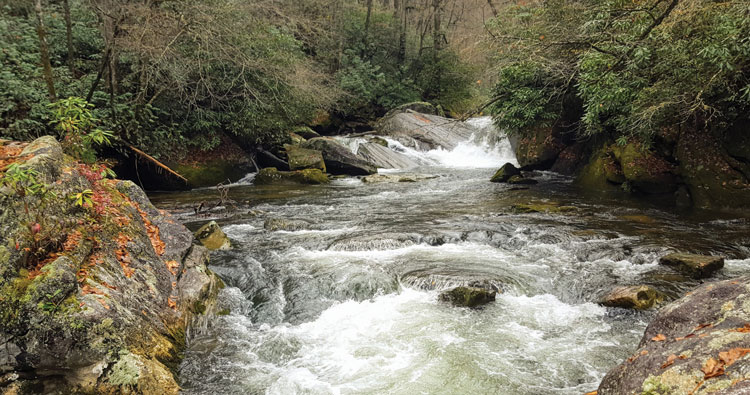
After heavy rains, it morphs from an idyllic trout stream into an “ultra-classic, super-fun” kayaking river, said J.E.B. Hall, a professional fishing guide and avid paddler. Plunging as much as 145 feet per mile through a gorge in Pisgah National Forest near Rosman N.C., the North Fork carries paddlers through both boulder gardens and chutes of solid bedrock. It features major drops such as Boxcar Falls that to average folks seem a lot better suited for viewing than running in a kayak. And if all this isn’t enough to qualify as a star attraction, the North Fork is flat-out beautiful, Hall said, with riverside cliffs looming behind bare branches in the winter and banks blanketed with wildflowers in the spring.
“It’s just really pretty down there,” he said.
Other hikers, anglers, and paddlers get similarly effusive when talking about nearby streams in the Nantahala and Pisgah National Forests, including Tanasee Creek, the relatively calm waters of which flow through a dramatic, V-shaped canyon, and Panthertown Creek, famous for its sandy beach-like banks and distinctive, tannin-rich water.
In fact, Kevin Colburn, national stewardship director of the paddling advocacy group American Whitewater, has compiled a list of ten additional streams (included below) that he thinks should be tagged as eligible for federal designation as Wild and Scenic Rivers in the next version of the Pisgah-Nantahala National Forest Plan. The current plan, in place since 1994, lists ten eligible rivers, and the U.S. Forest Service already intends to include ten more such streams in the new document.
“Doubling the number of eligible streams is a really good outcome, and we appreciate it,” Colburn said.
The final draft of the Pisgah-Nantahala Forest Plan is due to be released later this summer. So the time is right for the public to push for more of them to be protected by the eligible listing, Colburn said.
Congress passed the Wild and Scenic Rivers Act in 1968 to single out streams worthy of protection, especially from large hydroelectric dams. To qualify, rivers must not only be free-flowing, but, the law says, “possess outstandingly remarkable scenic, recreational, geologic, fish and wildlife, historic, cultural or other similar values.”
That’s where the public comes in, Colburn said. Enthusiastic users of these rivers, including paddlers, anglers, and hikers, might have a deeper knowledge of “outstandingly remarkable” attributes that the agency’s rangers and land planners.
“You can’t expect the Forest Service to know everything about every river,” Colburn said.
Veteran hiker Brenda Wiley of Brevard, N.C., may have a unique appreciation for Tanasee based on her multiple trips up the stream, a few miles northwest of the North Fork. The water is tame enough for creek-walking and offers views of landmark cascades such as Horseshoe Falls on tributaries dropping from canyon walls. The cliff at Horseshoe is not just sheer, “but the rock is gouged out well behind the waterfall and you have this free fall of a stream, and that’s just not typical at all,” Wiley said. “The geology there blows me away.”
Harper and North Harper creeks, another stream network on entry on Colburn’s list, flow through a Wilderness Study Area. Because much of the surrounding land south of Blowing Rock, N.C., has not been logged for about a century, it supports unusually magnificent forest, said Andy Kunkle, of Charlotte, who has led hiking trips in the area. One of the many view-worthy waterfalls on these streams is the confusingly named South Harper Creek Falls, which is actually on plain old Harper Creek. With a short bushwhack to the falls, he said, “you’re in a horseshoe-shaped canyon and you’re almost completely surrounded by cliffs.”
Ironically, Western North Carolina’s abundance of pretty, recreation-friendly mountain streams—the aspect that Colburn argues should work in favor of more listings—may actually work against it. It’s hard for any one of these creeks or rivers to stand out.
The Forest Service, for example, devoted three pages of its report to analyzing the North Fork of the French Broad. It acknowledges its popularity with paddlers in high water. But it also states that “challenging whitewater runs can also be found across other creeks and rivers throughout the region of comparison, including the Tellico and Ocoee Rivers in Tennessee and Wilson Creek and the Chattooga River in North Carolina.”
The report’s authors seemed similarly unimpressed with the river’s scenery. They described it as “typical for the Southern Appalachian Physiographic Province” and pointed out that the gorge is neither as deep nor as spectacular as the Linville Gorge in a tract of Pisgah east of Asheville.
There is, on the other hand, one powerful factor working in favor of Colburn’s cause: everyone supports it.
Designating a stream as eligible broadens the required buffer around it to a quarter mile. It restricts, but doesn’t prohibit, activities such as logging and prescribed burns within this buffer, and requires that the entire basin be managed in a way that maintains the stream’s “remarkably outstanding” qualities. Finally, it forbids altering the free-flowing nature of rivers that is the baseline prerequisite for either eligibility status or permanent designation as a Wild and Scenic River.
Wild and Scenic River eligibility status and the restrictions it carries are not necessarily permanent. That ultimately requires an act of Congress. And none of these restrictions apply to private land outside of national forests.
That may be bad for advocates of firm stream protection, but it’s good for blunting opposition of industry and private landowners. Alfred Owen owns Morgan Mill Trout Farm on Morgan Mill Creek. Though it doesn’t flow into the North Fork, it is nearby and trout farms are already subject to a host of regulations, meaning he might be expected to be wary of any new ones. But no, Owen said, he’d be fine with eligibility designation for the North Fork. His only concern, he said, is that the paddlers drawn by such designation would overwhelm the pull-off points that provide access and parking.
“You already see their cars sticking out in the road during heavy rains,” Owen said. “The more it rains, the more of them show up.”
A few miles downstream, David Whitmire staffed the taproom at Headwater Outfitters, a livery and guiding service he owns at the mouth of the North Fork. He supports listing the river as eligible. His business depends on the stream’s water quality and scenery.
But Whitmire is also the chair of the Fish and Wildlife Conservation Council, which supports expanded logging and hunting in the new plan, a position that sometimes puts him at odds with environmental organizations. On the matter of eligibility for the North Fork, however, he is right with them, and not just for business reasons.
Though the river, by virtue of passing through national forest land, is apparently protected now, he thought the same thing in the 1980s, when he joined the successful effort to stop a proposed dam on the North Fork. He’s an outdoors person who appreciates the excellent fishing and paddling on the river as much as anyone.
“It’s already a very protected resource and we’d like to see that locked in,” he said of the designation. “I just don’t see any downside.”
WNC Eligible Wild & Scenic Streams Under Consideration
USFS Currently Eligible Streams:
• French Broad
• Big Laurel
• Nolichucky
• Linville
• North & South Mills
• Snowbird
• Big East Fork
• Davidson
• Nantahala
• Tellico
USFS Draft New Eligible Streams
• South Toe
• West Fork Pigeon
• Flat Laurel
• Thompson
• East Fork Tuck
• Cullsaja
• Whitewater
• Overflow
• Santeetlah
• Fires Creek
Strong Candidates as Additional Eligible Streams
• Rock Creek-Toe Tributary
• Lost Cove Creek
• Harper & North Harper
• Gragg Prong
• North Fork French Broad
• Panthertown Creek
• Greenland Creek
• Tanassee Creek
• East Fork Overflow
• West Fork Overflow