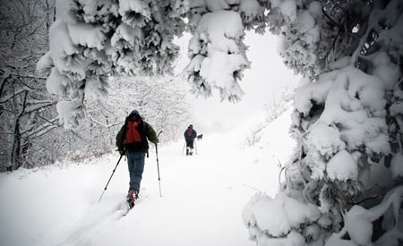
During spring, summer, and fall, these roads are blacktop avenues into the South’s most scenic mountains. But come winter, the snow falls, the plows steer clear, and these roads become cross-country ski highways, with Nordic skiers flocking to them for accessible, scenic adventures. The gentle grades and wide, obstacle-free nature of the roads also make them the perfect venues for beginner cross-country skiers. Our guide to road skiing the Blue Ridge features four roads prime for free-heeling fun, whether you’re new to the sport, or a hardened veteran.
Summit Road
Roan Mountain, Tenn.
The Roan Highlands, along the Tennessee and North Carolina border, see such consistent snow that the area once sported a legitimate backcountry ski guide service in the ‘80s. The pro guides may be long gone, but the area still sports a vibrant backcountry ski culture, with hundreds of skiers flocking to the 6,000-foot high massif, which receives more than 100 inches of snow a year.
“If there’s snow anywhere in the High Country, Roan is where it’s the deepest,” says Kristian Jackson, one of the founders of the High Country Nordic Association. “Whatever snowfall Beech Resort claims they get, Roan gets more.”
The backcountry options around Roan are endless, but the Summit Road, from Carver’s Gap up to the Rhododendron Gardens, is the quintessential Nordic kick and glide for beginners. On a weekend, you’ll find two dozen other skiers making their way up and down the road. Don’t shy away from the crowds. The Nordic community surrounding this alpine paradise is half the appeal.
Ski two miles up the road to the Rhododendron Gardens via a mellow grade through evergreens covered in snow. If you’re looking for more distance, a road bed on your left before you hit the gardens heads south, offering two more miles of out and back road skiing. From the Rhododendron Gardens, you’ll have views to the south (weather permitting) that take in Round Bald and Jane Bald.
- ACCESS: Park at Carver’s Gap, off Highway 19E, which is plowed regularly during the winter, and ski past the gates at the beginning of Summit Road.
- SKI REPORT: Members of the High Country Nordic Association post snow reports via their facebook page (facebook.com/pages/high-country-nordic-association).
- RENTALS: High Country Ski Shop at the Pineola Inn, has rentals and lessons. pineolainn.com
MAKE IT A WEEKEND
- GET SOME GRUB: Proper, in downtown Boone, has what could be the best fried chicken in the High Country. Order it, eat it, and send us thank you notes. propermeal.com
- ADD AN ADVENTURE: There are plenty of downhill options in the High Country. Some decent side-country terrain after a heavy snow makes Beech Mountain an appealing option. beechmountainresort.com
- STAY: Appalachian Ski Mountain offers winter camping with RV hookups, so you can plug in a space heater for deluxe accommodations. appskimtn.com
Dome Road
Clingmans Dome, Great Smoky Mountains National Park, N.C.
If snow is falling in the South, chances are it’s falling on the Tennessee-North Carolina border. During big winters, the big ridges along the border suck up most of the snow making its way from the south, with the 5,000-6,000 foot mountains along the border inside Great Smoky Mountains National Park getting hit the hardest and pulling in 100 inches of snow a winter. Most of those snow-covered peaks are isolated and rugged (a bad combo for beginner backcountry skiers), accessible mainly by the Appalachian Trail, which is often too steep and rocky to ski without a couple of feet of snow. But Clingmans Dome rises to 6,643 feet, just to the west of the state border, hogging a lot of that fresh powder, and it’s accessible via a seven-mile access road that’s gated and unplowed during the winter, turning it into a ski-highway for free-heelers. The Dome Road gets so much cross-country love, it’s spawned the Great Smoky Nordic Ski Patrol, an all-volunteer unit that has patrolled the Dome keeping skiers safe for decades.
The Dome is the highest point on the A.T., and your ski will start above a mile in elevation at Newfound Gap and culminate 6,600 feet above sea level at the parking area at the base of the Dome. You’ll start to see the observation tower five miles into the ski. Keep going and you’ll get views east through the park, into Nantahala National Forest, including Lake Fontana below. While the Smokies have become infamous for their hazy views, winter offers postcard-worthy blue skies and long-range vistas. If you’re not up for an epic all-day adventure, ski to Collins Gap, halfway to the dome on the road, before turning back to Newfound Gap. If you’re looking for more technical terrain, the Appalachian Trail parallels the entire length of the road.
- ACCESS: Pick up the gated Dome Road at Newfound Gap, on US 441, which is plowed after storms by the Tennessee Department of Transportation. Go as quickly as you can after a storm hits, as the Dome Road is south-facing, and can melt quickly.
- SKI REPORT: Keep an eye on High On LeConte, a daily blog from the crew that mans LeConte Lodge during the winter months. They’ll report when a storm hits, and how much snow has fallen, which will give you a good idea of the conditions on Clingman’s Dome. highonleconte.com
- RENTALS: Sadly, you’re on your own this far south.
MAKE IT A WEEKEND
- GRAB A DRINK: Grab a bottle of Apple Pie Moonshine at Ole Smoky on the main drag in Gatlinburg. olesmokymoonshine.com
- GET SOME GRUB: No Way Jose’s offers standard Mexican fare with river views in downtown Gatlinburg. nowayjosescantina.com
- ADD AN ADVENTURE: If you’ve got the legs, a hike to LeConte Lodge on Mount LeConte is one of the South’s quintessential winter adventures. From Newfound Gap, take the A.T. to Boulevard Trail, for an eight-mile trip to the top of LeConte. Hit the lodge between 12-3pm and you can have lunch and hot chocolate at the lodge. You might need crampons or snowshoes if it’s a good winter. lecontelodge.com
- STAY: You’ll find plenty of lodging in Gatlinburg, but head to Townsend and stay at Dancing Bear Lodge, which has a bar and a couple of miles of trails on-site. dancingbearlodge.com
SKYLINE DRIVE
Shenandoah National Park, Va.
If you think Skyline Drive is stunning during the warm months, wait until you see it during the winter, with a fresh blanket of snow, crystal-clear long-range views, and absolutely no crowds. The 105-mile highway runs the length of Shenandoah National Park, undulating between 2,000 feet and 4,000 feet, offering 75 consecutive overlooks. It’s a hell of a drive. And every once in a while, it’s a hell of a ski…if you can clear your schedule.
“It’s hard to plan a trip to ski Skyline, because the snow is never guaranteed,” says Robert Swennes, president of the Potomac Appalachian Trail Club’s Ski Touring Section. “You’ve got to be ready for a spontaneous trip. When the snow falls, have your skis in the car, ready to go.”
The good news is, when the snow does fall, most of the road is skiable. The park service doesn’t plow the highway, and the pavement offers rolling terrain, except for the southern and northern terminuses, which offer formidable climbs. Instead, head for Thornton Gap, near the middle of the park at milepost 31, close to the park headquarters. Ski south toward Hazel Mountain Overlook. You’ll have to walk your skis through Mary’s Rock Tunnel, but keep going and you’ll get to Buck Hollow Overlook with a fine view to the north that stretches from Hogback Mountain to Sperryville. Ski to milepost 33 and you’ll hit Hazel Mountain Overlook with a view of Old Rag. If there isn’t enough snow to shut down the road completely, make a beeline to Big Meadows, at milepost 51, where broad, level trails offer beginner-friendly cross-country potential around the campground and hotel. And keep in mind, the Appalachian Trail is never far from Skyline Drive if you’re looking for more technical turns.
- ACCESS: Take US 211 (plowed during the winter) from Luray or Sperryville into Shenandoah and park at Thornton Gap, where the plowing stops. Head south.
- SKI REPORT: Shenandoah has an automated line that will let you know if Skyline is closed due to snow: 540-999-3500. Even better, the park service runs a webcam that shows Big Meadows along Skyline Drive. If Big Meadows has snow, head for the hills.
- RENTALS: Nordic gear is tough to find in Virginia–you’re on your own.
MAKE IT A WEEKEND
- GRAB A DRINK: Drop into Sperryville, east of the park, for a tour and tasting of Copper Fox Distillery, producers of fine gin and whisky. Copperfox.biz
- GET SOME GRUB: Head straight for the pulled pork sandwich at Triple Crown BBQ, a roadside shack in Luray. It’s only open Thursdays through Sundays, so hopefully the snow will hold off until the weekend. 540-743-5311.
- ADD AN ADVENTURE: A winter hike up Old Rag, Shenandoah’s most notable peak, is a must for anyone who’s up for some icy rock scrambling and epic views.
- STAY: Grab a cabin at Brookside Cabins, on US 211 between Luray and Shenandoah National Park. brooksidecabins.com
HIGHLAND SCENIC HIGHWAY
Pocahontas County, W.Va.
Highland Scenic Highway gets its name honestly: it’s the highest major highway in the Mountain State, topping out at a lofty 4,700 feet and passing through some of the Monongahela National Forest’s most dramatic landscapes, from spruce-fir forests to high elevation bogs. The eastern terminus of the 43-mile highway is only 20 minutes from Snowshoe Mountain Resort and is often hit by the same storms that make Snowshoe one of the snowiest spots in the Mid-Atlantic. The highway gets an estimated 150 inches of snow every winter, and thankfully, is never touched by a snowplow.
“The highway gets a lot more snow than the valley below, and isn’t maintained during the winter, so you can ski right down the road,” says Julie Royer, who works at the nearby Elk River Touring Center. Head to the highway’s intersection with US 219, outside of Marlinton, where a parking area serves as a cross country trailhead during the winter. Ski two miles up the highway to your first overlook, Red Lick, which offers views of the surrounding Allegheny Highlands. You’ll have some up and down along the trip, but it’s a highway so expect a mellow grade overall.
While you won’t see a snowplow on the road, you might see the occasional snowmobile, which can often be a blessing—skiing in the track of a snowmobile is drastically easier than breaking through new snow.
If you want more of a challenge, some popular cross-country trails begin at the parking lot offering a more primitive experience. The other end of the Parkway is popular with experienced skiers as well, who will park at the Cranberry Mountain Visitor Center and ski the trails surrounding the Cranberry Glades.
- ACCESS: Follow US 219 north from Marlinton and park at the intersection with W.Va. 150 (Highland Scenic Highway). US 219 is plowed.
- SKI REPORT: Watch Snowshoe Mountain’s website for daily snow reports. If Snowshoe is hit by a storm, chances are the Highland Scenic Highway is covered too. snowshoemtn.com
- RENTALS: Elk River Touring Center, in Slatyfork, has everything you need, including lessons and beginner-friendly trails on site. ertc.com
MAKE IT A WEEKEND
- GRAB A DRINK: The Connection, Snowshoe Mountain’s night club, is an adventure all on its own. snowshoemtn.com
- GET SOME GRUB: Pretty Penny, off 219, gets most of their ingredients from surrounding farms. prettypennyfood.com
- ADD AN ADVENTURE: Snowshoe Mountain offers legitimate downhill turns close to the Highland Scenic Highway. Go to Cupp’s Run for steeps and moguls, and Silver Creek for trees.
- STAY: Your best bet is Snowshoe, so the Village is at your doorstep. snowshoemtn.com


