Mountain bikers explore the uncharted Rocky Fork—the newest and largest land acquisition in the Southeast in decades.
You can tell it’s bear scat because it looks like someone dumped a bucket of blueberries on the trail,” Ben Appleby says, leaning over his handlebars to get a peak at the black pile in the middle of the trail.
I don’t care what animal left the mess. I’m just happy for the break. We’re riding a brutally primitive logging road inside the Rocky Fork Tract in eastern Tennessee. The terrain is steep and unforgiving, and we’ve been climbing since we left the trailhead two hours ago. I’ve lost count of the streams we’ve had to ford, and we’re so deep into the backcountry that if Appleby decided to leave me, I’d have to send up a signal flare for help.
Appleby sees the pain on my face and tells me, “It’s worth it.” I know he’s talking about the view from Buzzard Rock that we’re pedaling toward, but really, he could be talking about the Rocky Fork Tract in general. Rocky Fork is a 10,000-acre chunk of land that hugs the Tennessee-North Carolina border along Interstate 26 between Johnson City and Asheville. It’s flanked by the Cherokee National Forest on the west and the Pisgah National Forest on the east. Until recently, it was one of the largest contiguous tracts of private forest land left in the eastern United States. In December 2008, a coalition of environmental groups led by the Conservation Fund purchased the Rocky Fork for $40 million from New Forestry, a logging company based in Georgia. There were rumors that developers were looking to turn the tract into a gated resort, but the Conservation Fund, along with the Southern Appalachian Highland Conservancy and the Appalachian Trail Conservancy, showed up with cash in hand, pulling the Rocky Fork off the auction block.
Saving the Rocky Fork tract is arguably the most significant land conservation coup of the decade. The Conservation Fund holds the deed to the property now, but has been transferring the land piecemeal to the Cherokee National Forest and state of Tennessee when federal and state funds become available. It’s an important environmental victory that preserves a portion of the A.T., secures the future of a pristine watershed, and bridges a significant gap between two national forests. But purchasing the land is just the beginning of Rocky Fork’s story. Now, the tough questions of how to manage the land must be discussed. How exactly should 10,000 acres of unspoiled mountains and streams be used? If the conservation and outdoor groups that saved the land have any say in the matter, Rocky Fork will become the South’s next great mountain bike destination.
Uncharted Territory
The trail we’re riding has no name. It’s actually a logging road that, from the looks of things, hasn’t been maintained in decades. Rhododendron pushes into the road on the left. On the right, the bank dives steeply toward a drop-and-pool creek that’s home to native brook trout. The creek is so clear you can count the stones on the bottom. The road itself is doubletrack filled with momentum-killing rocks the size of my bike helmet. The pedaling is slow and laborious but the scenery is impeccable. On either side of the creek, the green walls of mountain rise steeply toward the sky.
Appleby finds a level piece of ground and we stop to assess our location on the map. The topo shows ridges and valleys ranging from 2200 feet to 4800 feet, and almost every valley has its own skinny blue stream. The most significant is the Rocky Fork itself, home to clear water, house-sized boulders, and native trout. A network of squiggly logging roads cuts through the terrain like spaghetti noodles on a plate, but the accuracy of these roads on the map is questionable at best.
“Most of these roads aren’t where the map says they are, and then there are a bunch more that aren’t even on this map,” Appleby says. He’s a graduate student at Eastern Tennessee University and an endurance biker who likes to put together eight-hour rides on the primitive roads of Rocky Fork and surrounding recreation areas. His role in the Rocky Fork transfer is to help create a reliable map for the area. To accomplish this, Appleby spends much of his free time biking the existing roads with a GPS and transferring those details onto a large, crisp topo map.
He lays this pale topo map on top of the Trails Illustrated map to keep it from getting dirty and shows me roughly where we’re sitting. The map is still a work in progress. The green ridges and blue creeks are scored with a dozen brightly colored trails inked by hand. We’re about halfway up a dark red vein that cuts through the heart of the tract. According to the topo, we haven’t even begun the serious climbing yet.
“It’s raw,” Appleby says, staring over his own map. “There isn’t a lot of singletrack here, but there are lots of road beds to explore. Imagine Pisgah 25 or even 50 years ago. That’s Rocky Fork right now.”
Appleby’s talking about the Pisgah Ranger District, a fabled hiking and biking destination in Western North Carolina. Just an hour’s drive east of Rocky Fork, Pisgah is one of the most visited national forest districts in the country. The quantity and quality of trails in Pisgah has helped turn Asheville, N.C. into a hub of mountain biking and outdoor recreation.
On the other side of Rocky Fork is Johnson City, which has slowly been evolving into a mountain bike town in its own right, thanks in large part to the Northeast Tennessee Mountain Bike Association, a proactive group that’s built miles of popular singletrack in Warrior’s Path State Park, Bays Mountain, Buffalo Mountain and Dark Hollow.
And yet, Rocky Fork, which sits exactly half an hour between these two active mountain bike communities, hasn’t seen one mile of trail development.
“There aren’t even any user-created trails in there,” says Bob Lamberson, a 58-year old biker who can see Rocky Fork from his house. Lamberson is the biker who introduced Appleby to Rocky Fork. He rides the mountains on a rigid singlespeed and estimates he’s logged more miles in the tract than any other mountain biker. “It’s never been poached. Do you know how rare that is?”
How the 10,000-acre tract has escaped development of any kind is a bit of a mystery. Perhaps it’s because the terrain is so steep. Or maybe it’s because the Tennessee Wildlife Resources Agency, which has leased the land for the last 50 years, keeps the main entrance gated. Or maybe it’s just luck. The Rocky Fork landscape is admired by millions of interstate travelers from an overlook perched on the edge of I-26. Yet it has remained essentially unspoiled, and some would argue a massive opportunity for sustainable recreation.
Mountain Bike Mecca
“The potential is huge,” Appleby says. “Rocky Fork could be a regional or even national recreation destination. If you took the same density of trails present in places like Dupont State Forest or Bent Creek and overlaid it on Rocky Fork, we’d be looking at 100 miles of singletrack here.”
What may come as a surprise is that the environmental organizations responsible for protecting the Rocky Fork are expressing support for recreation and trail development at Rocky Fork.
“The Rocky Fork could easily be as popular as Bent Creek,” says Morgan Sommerville, regional director of the Appalachian Trail Conservancy (ATC). The ATC was particularly interested in preserving Rocky Fork because the Appalachian Trail crosses it for 1.5 miles, and 4,000 acres of the Rocky Fork lie within the A.T.’s viewshed.
“I’d like to see the Rocky Fork get at least as good of a trail system as Bent Creek,” continues Sommerville. “Bent Creek’s parking lot is full every day with bikers and runners. There’s at least one bike shop within a stone’s throw of that forest. That’s what I’d like to see at Rocky Fork.”
To the environmental community who rescued Rocky Fork, recreation development sounds a whole lot better than the gated resort that was nearly built there.
“They wanted ski slopes, golf course, houses,” says David Ramsey, a Unicoi County native who served as the local coordinator for The Conservation Fund. “There was a headline in the local paper: ‘Rocky Fork: The Next Wolf Laurel?’ That’s when I knew this would be our last chance to save this land.”
Ramsey can trace his family ties to Rocky Fork back five generations (his grandfather was actually born on the tract). He has spent the past 13 years organizing a grassroots movement to preserve the land. While turning Rocky Fork into a publicly owned forest or park has been overwhelmingly supported by Unicoi County natives, Ramsey says a few local leaders wanted Rocky Fork developed into a resort simply because so much of Unicoi County is already public land and out of the county’s tax base. The U.S. Forest Service manages roughly 50 percent of the county’s land mass, and bringing another 10,000 acres into the public fold would remove a significant portion of Unicoi’s taxable land.
In order to win over the local leaders, The Conservation Fund had promised that Rocky Fork would become a driving force for the economy of Unicoi County. It wouldn’t become a ski and golf community, but it could bring tourism to the area.
“We had to present alternative concepts to development,” says Rex Boner, vice president of the Southeast Region of The Conservation Fund. “Instead of a gated community, could Rocky Fork become a state park? A national recreation area? We’d like to encourage that as much as possible.”
The Northeastern Tennessee Mountain Bike Association (NTMBA) sees Rocky Fork as the missing link to the Volunteer State’s biking portfolio.
“There’s not a lot of backcountry singletrack in the Cherokee National Forest,” says Anthony Duncan, president of the NTMBA. “Many bikers drive through the Cherokee National Forest on their way to Pisgah. We want people to come to Northeast Tennessee for mountain biking.”
Cherokee National Forest hasn’t discussed specific management plans for the area yet, but recreation seems to be a top priority.
“We’re actively seeking opportunities to create more primitive trail systems,” says Terry Bowerman, the ranger for the Unaka/Nolichucky district of the Cherokee National Forest, where the Rocky Fork presides.
Cherokee National Forest recently hired four trail technicians to maintain the current trail system as well as plan and lay out new trails. The Forest Service has also been working in Unicoi County to increase recreation-based tourism in the area, building new trail systems at Dark Hollow and Buffalo Mountain, and restoring the old Pinnacle Fire Tower and the Unaka Mountain Overlook.
“The management prescription for the Cherokee lands surrounding Rocky Fork calls for providing appropriate recreation opportunities,” Bowerman says. “Even if we use a different prescription for the tract, we manage all of our grounds for different forms of recreation.”
Jay Leutze, board member of the Southern Appalachian Highlands Conservancy, doesn’t want to leave Rocky Fork’s future to chance.
“I’d like to use the Friends of Dupont forest as a model,” Leutze says from his office in Asheville. “When the management future of that forest was in question, Friends of Dupont started getting people out there to show the land managers that a park and its economic benefits were inevitable. We’d like to do the same for Rocky Fork.”
This is where the new recreation map comes in. Ramsey hopes the map will prompt more outdoor enthusiasts to explore Rocky Fork.
“There’s a lot to see inside the Rocky Fork, but unless you go with someone who knows the area, you have no idea where anything is,” Ramsey says. “My main interest right now is to make it easier for recreation users to go there safely.”
The Long Road Ahead
“I think I know where it goes, but you can never be sure,” Appleby says, nodding to a roadbed that’s almost entirely overtaken by young hardwoods and low-lying brush. We’ve passed half a dozen similarly mysterious roadbeds since we started our climb. Appleby and Lamberson are in the process of exploring all of them. “Half the time, we end up carrying our bikes over our head through thick brush,” says Appleby.
This grassroots exploration is necessary for the recreation to blossom at Rocky Fork. After Appleby and Ramsey inventory the existing roads, a decision has to be made about which roads will be allowed to revert to singletrack and which will be kept doubletrack. Then the land managers and bikers will decide which existing roads should be connected into loops with freshly cut trails.
“It’s mind-blowing to think about the possibilities,” says Anthony Duncan with the NTMBA.
Mountain biking is just one piece of the recreation pie. Given the Rocky Fork’s proximity to the A.T., Sampson Mountain Wilderness, and other primitive recreation areas, new long-distance backpacking loops are also a possibility. The amount of rock cliffs and boulders on the land has made Appleby curious about the climbing potential as well. Eager to build support for recreation development in the Rocky Fork, Ramsey has begun giving a series of presentations for outdoor clubs and outfitters in the area that proposes turning the Rocky Fork and select acres of surrounding national forest into a National Recreation Area similar to the nearby Mount Rogers National Recreation Area in southwest Virginia.
“A lot of the infrastructure is already here, and the recreation is top notch,” says Ramsey. “Why can’t Rocky Fork be the next national recreation area?”
But all this speculation is years from becoming a reality. The truth is, the federal and state land managers don’t know what sort of recreation potential they have on their hands. They don’t even know what animals live in Rocky Fork. It’s assumed there’s a high concentration of black bear within the tract, and peregrine falcon nests were spotted in the area. One biologist found a salamander at Rocky Fork which may be a new species altogether.
Appleby is waiting for the state biologists to unearth whatever creatures they can before he starts climbing any rock, and he hopes mountain bikers can be just as patient before they start digging new trails.
“The last thing we need is people in here building illegal trails,” Appleby says as we reach the top of our climb and rest our bikes against a couple of hardwoods. “We have to be patient. The process is going to take a while, but it’s worth it.”
Rex Boner of the Conservation Fund echoes Appleby’s call for patience. “We don’t have too many opportunities to do large scale conservation and recreation projects within our backyards. We need to think about smart, long-term management practices.”
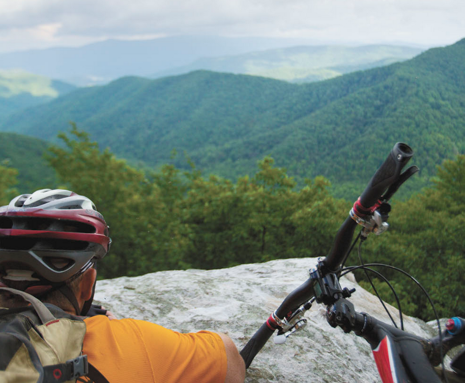
We leave the bikes and walk about 50 yards on a thin vein of singletrack cutting through a tunnel of rhododendron and blueberry bushes. The trail ends at Buzzard Rock, a narrow cliff with a sheer drop-off and long-range views. I crawl to the edge of Buzzard Rock and peer over the cliff. The ground is swallowed by a sea of green hardwoods, but in front of us is a view of nearly the entire Rocky Fork Tract. The green mountains rise and fall below our feet for miles in either direction. I can see the thin ribbon of I-26 on the far end of the tract.
Appleby points to a valley miles below us. “That’s where we started,” he says.
His finger traces an approximation of the miles we rode along the landscape below us—the mountains climbed, valleys traversed, rivers crossed—just to reach this rock and see this view.
Absorbed in the beauty, I forget how difficult it was to get here. I turn to Appleby and smile: “It was worth it.”
ROCKY FORK AT A GLANCE
Acreage: 9,624 acres along the Tennessee and North Carolina border in Unicoi and Green Counties.
Ownership: Last December, the U.S. Forest Service purchased 2,237 acres which was added to the Cherokee National Forest. The Conservation Fund purchased 7,387 acres, which it will transfer to the state of Tennessee and U.S. Forest Service when funds become available. The state is expected to take over 4,159 acres in the center of the tract. The designation of that land is still undecided and could be anything from a primitive wildlife management area (as it’s currently managed) to a state park.
Management Practices: Rocky Fork is currently open to the public and is managed as a wildlife management area. The tract is open to hunting, fishing, hiking, running, and mountain biking. No camping, no horses, and climbers should wait until full biological studies can be performed before climbing.
Directions: From I-26, take the Flag Pond exit. At the stop sign turn left onto Higgins Creek Road. Drive .5 mile, then turn right on route 23. Drive 2.25 miles through Flag Pond, then turn left on Rocky Fork Road. Drive .75 mile to a gravel pull-off to the left in front of a gate. From here, explore Rocky Fork on foot or bike.
ROCKY FORK HIGHLIGHTS
Buzzard Rock: Sandstone outcropping perched above 4,000 feet overlooking most of the Rocky Fork Tract.
The Ball Ground: A small natural bald that sits adjacent to the A.T. near Buzzard Rock.
Rocky Fork Creek: Native trout stream running through the center of the tract offering backcountry fly fishing, swimming holes, and potentially rock climbing.
Man-made lake: A seven-acre, un-named lake sits at 3,000 feet on the western side of the tract near Bartsville Camp Branch.
Appalachian Trail: The A.T. adjoins the Rocky Fork for 1.5 miles, much of which is being rerouted off a logging road onto singletrack by the Appalachian Trail Conservancy. “We’ve wanted this reroute for decades,” Morgan Sommerville of the ATC says. The trail intersects Rocky Fork on the new Cherokee National Forest land near Buzzard Rocks. The former trail followed an underwhelming forest road that received some illegal ATV use. “It’s the A.T., so it’s not supposed to be on a forest road,” explains Sommerville. “Now the trail moves through some nice northern hardwoods with pretty views.”
WILDLIFE WONDERLAND
Rocky Fork is part of the Unicoi Bear Preserve, and its protection ensures an important bear habitat will be kept intact. But the Rocky Fork is home to more than just black bear. In all, 10 species of “greatest conservation need” have been recorded on the property through state-led “bio-blitzes.” When you explore Rocky Fork, keep an eye out for these rare animals.
Native Brook Trout: Brook are Tennessee’s only native trout and have been on the decline for decades because of competition from other trout species introduced to the area. Currently, brook can only be found on 150 miles of mountain streams, half of which are in the Great Smoky Mountains National Park.
Peregrine Falcon: The world’s fastest animal, (Peregrine falcons can reach speeds of 200 mph), peregrines feed on smaller birds and nest in cliffs near water sources. While their numbers have been on the rebound in recent years, the peregrine was once endangered due mainly to the use of DDT.
Yonahlossee Salamander: A black and brown salamander whose worldwide range is concentrated in only a few mountain counties in Tennessee and North Carolina. The discovery of the yonahlossee in Rocky Fork extends the range of this salamander into an area previously unthought of as suitable habitat.
Woodland Jumping Mouse: Found in the northeastern U.S., Canada, and in a narrow strip of the Southern Appalachians, this small mouse walks on its hind legs and is able to jump distances up to eight feet.


