The James River Association (JRA) and Richmond-based Outside Ventures, LLC, have embarked on a digital filming project to capture the scenery of the James River in a completely new way.
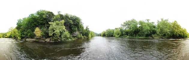
For the first time, online viewers will be able to explore the entire 340-mile length of the James River through high-resolution, 360-degree panoramic images. The Tour of the James will be the first comprehensive photo documentary of an entire river and will allow viewers to travel from the headwaters of the James to its mouth at the Chesapeake Bay.
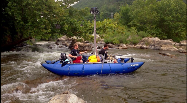
Six cameras mounted on a stainless steel housing 10 feet above the water’s surface will capture panoramic photos every 30 feet from a custom-made pontoon raft floating down river. These high-resolution photos will then be stitched together to create a 360-degree augmented reality map of the river corridor.
The Tour of the James was initiated as a result of Envision the James, a collaborative effort between National Geographic, the Chesapeake Conservancy and JRA. It is the hope that the Tour of the James will share the river experience with a wider audience, empowering Virginians to further explore the wild beauty of the James River.
The project will include a virtual and interactive interpretation of natural, recreational and historic features in the river corridor, such as notable rapids, boat ramps and Civil War sites.
“The project is going well, though slower than anticipated due to lower water in the James. In deeper sections, we can use the 2.5-horsepower gas motor, and we make really good time. But with the lack of rain throughout the watershed, we’re scraping the bottom a bunch and we can’t use that more powerful motor,” said Outside Venture’s Andy Thompson.
“It’s important for a couple of different reasons,” said Thompson. “First, it’ll be the first entire river mapped in this way. Google did about 200 miles of the Colorado River. We’re doing the whole James — 340-ish miles — and we’re doing it with better cameras and higher-resolution images. Second, the finished tour will be like a base map that will allow us to create what we call “augmented reality” maps of the river. Imagine a regular 2D map with clickable waypoints (that give you more information/images/video about a given sight) but in 3D. So, for instance, you could use our tours to create a panoramic image map of bald eagle nests in the tidal James River. Or a map of historical sites, boat ramps, fishing holes, etc. The tour of the river and all the sections that we break it up into will be cool, but the really neat aspect of all this going forward will be the maps we can create with those panoramic scenes.”
Follow along with the trip via Twitter (#mapJR and #EnvisionTheJames) and Instagram at @Terrain360. To see examples of Outside Ventures’ other 360-degree tours, visit www.terrain360.com.


