Mackey Mountain Roadless Area
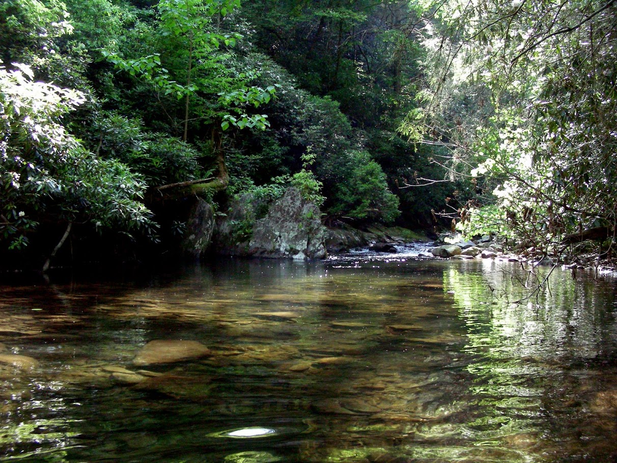
The sign along Curtis Creek Road outside of Old Fort says First tract of National Forest Land purchased under the 1911 Weeks Act, but I realize soon after entering the 15,000 acre Mackey Mountain area that this is but one of the reasons to insure the protection of this tract forever as Wilderness. Lying within an assemblage of mountains unparalleled in the eastern United States for their remoteness, high quality roadless values, and contiguous old growth acreage on National Forest land, Mackey Mountain sits like a diamond upon the earth with its numerous superlatives, vast and incomparable. I’m heading into it via the Hickory Branch Trail out of Curtis Creek Campground. It’s a pleasant walk along the beautiful Hickory Branch and then a steep uphill climb before reaching the ridgeline. I’m scouting this trail for an upcoming hike I am leading for the Carolina Mountain Club, and several CMC members and Wilderness Society Ecologist Hugh Irwin, have joined me for the day.
To the east is the main body of the Roadless area, unbroken forest with no sign of human structures as far as you can see. On the far ridge is the Mackey Mountain Trail bisecting the length of the area, meandering along the Mackey Mountain ridgeline for almost eight miles, through montane old growth forests of Chestnut Oak, Northern Red Oak, Hickory, as well as impressive sprouts of American chestnut. Much of Mackey Mountain was never cut, largely due to the inaccessibility of the area. At least 5,500 acres of uncut forest – hard to believe given the magnitude of early 20th century industrial logging in western North Carolina, but there it is – all before me and nothing short of a miracle.
At length, we reach the ridgeline, which is a series of steep jagged ascents and descents as we wander a few miles to Buckeye Knob. Along the way and around the summit of Buckeye Knob, grow significant populations of Carolina Hemlock, an endemic species centered in this portion of the Pisgah National Forest as well as Table Mountain Pine, and an abundance of American Chestnut sprouts. The rare and unusual Turkey Beard (Xerophyllum asphodeloides) is also abundant here. Found mostly to the north of here in the Pine Barrens of New Jersey and on dry, granitic rocky ridges in Appalachian Virginia, this strange and showy fire adapted plant seems to love and get along well with this rugged place. The Buckeye Knob Trail continues on and comes out on the Curtis Creek Road near the Mackeye Mountain Trail. We won’t be hiking this stretch today, but from Buckeye Knob we can look into the main body of the area, the most intact portion of 8,100 acres that Burke McDowell Lumber Company sold to the US Forest Service for seven dollars an acre in 1912.
 To me, nothing could be more appropriate for this area than a Wilderness designation. The intention of the Weeks Act legislation in 1911 was to purchase lands for a new National Forest system in the eastern United States in order to protect watersheds. Decades of cut and run industrial logging had laid waste to much of the mountainous eastern US, leading to devastating floods and fires, and purchases made under the Weeks Act were to insure that this would never happen again. With watershed protection one of its primary objectives, Wilderness would honor that intention greatly. There would be no threat of commercial resource extraction, road building, or mechanized or motorized recreation. This important historical tract would be permanently protected. With the exception of traditional uses such as hunting, fishing, camping, and horseback riding, it would be managed much like the nearby protected Asheville watershed.
After lunching at Buckeye Knob, we return along the ridge to a point where the Hickory Branch Trail leaves and drops back down into the Hickory Branch drainage. Here we depart from the designated trail onto an old unmaintained trail that travels further south onto the ridge and into a stand of more distinctive hardwood old growth – large oaks and hickories, silverbell, tulip trees, and more. We wander about for a while, enjoying the silence and the rarity, perhaps all of us acknowledging what the ancient Romans described as the genius loci, or spirit of the place. Wilderness may be conceptual, a western idea that helped define us as a nation and a product of our collective imagination, but regardless its definition and designation gets at the idea of protecting such spirits – both ours as human beings and those that are both imagined and experienced when coming into such a place.
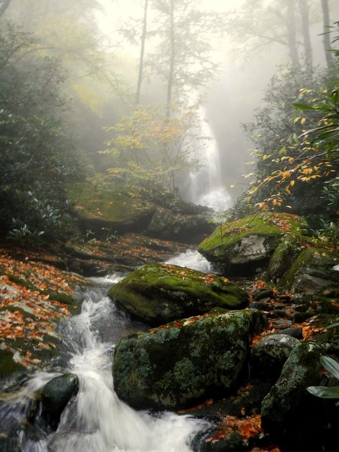
On the day of the official outing, a group of twenty three shows up and it is more than I had hoped for. Such a large group can be difficult to manage as well as enjoy for many reasons, among them being that each person can have a different reason for being there – some want exercise, some want to meet potential partners who like to hike, some simply need something to do – a challenge when what I want is for them to experience the place in as direct a way as possible by understanding its conservation values and uniqueness. We spread out in a long straggling line and head up the trail, stopping at Hickory Branch Falls for a few minutes so that everyone can catch up and enjoy the great white cascade descending through the dense forest. Everyone enjoys a cool and pure Appalachian waterfall, no matter the reason for being there. And everyone there enjoys being in the great outdoors and being in such moments as this. I think too, after a long day of hiking, talking, and observing with all of these great CMC members, that we all want such places protected permanently, both for ourselves and for the future.
Black Mountains
At 10.5 miles with a 4,200 feet elevation gain, The Black Mountain Crest trail is one of the most challenging trails in the east, traversing the highest mountain range in the eastern United States. I am heading out on it today from Mt. Mitchell State Park with a few of my colleagues at The Wilderness Society in order to meet up with a Southern Appalachian Wilderness Stewards (SAWS) crew, which is re-working a badly eroded steep section of trail about seven miles out from here. This young and energetic crew has been in the backcountry here for a week, providing much needed trail maintenance and, perhaps more importantly, gaining a lifelong appreciation and dedication for the protection of Wilderness. The Black Mountains aren’t protected as Wilderness, but the opportunity for this to happen is now. The Forest Service is revising its management plan for the 1.1 million acre Nantahala-Pisgah National Forest, and with the Blacks weighing in with the largest concentration of roadless lands in the entire forest, it should rise to the top when they are performing Wilderness evaluations. 15,000 acres of roadless land form the heart of the area, and with Mackey Mountain, the Big Tom Wilson Preserve, Mt. Mitchell State Park, Craggy Mountains, Blue Ridge Parkway, and the nearby Asheville watershed there is a concentration here of over 50,000 acres of state, federal, and privately owned conservation lands. Most of us living here in the southern Appalachians understand the value of such large blocks of conservation ownership, along with the need for giving the highest level of protection – wilderness – to some of that acreage. I think 1,000 years ahead when considering this level of protection, as well as 1,000 years back, envisioning this landscape both as it might have been, and what it might become. It requires a certain humility to protect a place as wilderness, a perspective that accepts limits and minimizes what we might consider our immediate needs and demands as a species. Yes, we have now altered the entire planet in many ways, but as a Forest Service archaeologist once said to me, the good news is that we know exactly how long it takes to grow a four hundred year old white oak.
We head on out the Black Mountain Crest Trail, through remnant and suffering Spruce-Fir forest that still dominates these high elevation peaks. Climate change is a real threat to this ice age relic forest type, as well as air pollution, and the future for many of the rare species that are found here, such as Rock Gnome Lichen and Spruce-Fir Moss Spider is uncertain. I struggle with a heavy pack, using the cables that assist in both ascending and descending several of the trails numerous steep sections, realizing that tomorrow I will be greeted with sore muscles and a stiff back. But the forest is spectacular, and the fragrance of spruce and fir is refreshing and clean. We eventually make our way to Deep Gap, a grassy spot with a few flat camping areas and a fantastic view to the north nearby. The SAWS crew is just down the trail from us, and we dine that night with them, listening to the many trail tales they have gathered from another summer spent providing trail work in wilderness.
They are working this section of trail in coordination with the High Peaks Trail Association out of nearby Burnsville, and that evening the president of High Peaks, Jake Blood, hikes in from a side trail to have dinner with us. Jake is one of the founders of High Peaks, and in addition to serving as “Friends of Mt. Mitchell State Park” they maintain the trails of the Black Mountains, and are working to connect the city of Burnsville in a trail system to the Black Mountains through creative partnerships with city and local government, private landowners, and non-profits. They are also pro-Wilderness for the Blacks, realizing the high level of protection it would give them, and at the same time realizing that they will no longer use motorized equipment for trail maintenance. We are all confident in the long term support of SAWS though – this five year old organization is growing leaps and bounds, and it has developed a proven track record of caring for trails in Wilderness, as well as building the next generation of Wilderness lovers and stewards. SAWS attention to areas that are potential Wilderness, such as the Blacks, makes the organization all the more visionary.
SAWS and High Peaks are part of a long history of people and organizations working to protect the Blacks, and this history is significant. The Blacks had existed largely as a wilderness until the late 1800s, when lumber operations began building railroads into the mountains to haul out the area’s magnificent timber. Pennsylvania lumbermen, Fred Perley and W.H. Crockett bought timber rights to 9,000 acres in the Blacks, and built a railroad that climbed 3,500 feet over 21 miles, coming within a half mile from the summit of Mt. Mitchell, astonishing the general public. Other lumber companies, such as Carolina Spruce Company and Murchison Lumber, also built rail lines into the Blacks, and together they logged several hundred million board feet of old growth Spruce, Fir, and other timber species. This level of logging created a movement in the early 20th century to protect Mt. Mitchell, the highest mountain in the eastern United States, leading to the successful creation of a state park in 1915. Perle and Crockett’s railroad then became one of the most popular tourist destinations in the eastern United States.
The US Forest Service also began acquiring tens of thousands of acres in the Blacks, restoring eroded and overcut lands, which ultimately led to another movement to create a National Park out of the Black Mountains. Led by one of America’s foremost conservationists, Michael Frome, this movement actually succeeded in the short term. A bill to establish the park was introduced by local Congressman Roy Taylor, which passed in September 1976. However, neither Frome nor Taylor, were prepared for the local backlash by residents of Yancey County, who were concerned about tourist impacts on their rural way of life. Taylor’s successor, Lamar Gudger, supported Yancey County residents, and the park initiative died within two years.
Yet wilderness is a viable option for the Black Mountains. Nothing about this designation would change current uses, and protection would be insured. In fact, this was what Aldo Leopold, great American ecologist and founder of The Wilderness Society, had in mind when creating this visionary conservation option. Leopold had seen how the emerging National Park system of the nineteen twenties was intent on building roads, tourist and recreation facilities, and changing traditional uses of the land. Wlderness was an alternative to the parks – its users could still hunt, fish, ride horses, and camp and there would be no threat to it, as there would be no new roads, buildings, or infrastructure. It was a place to be free of such threats to wild nature, and this was permanent.
The Blacks are still such a place, and tomorrow when I work a short day with the SAWS crew, and then almost crawl back to Mt. Mitchell with my heavy pack and screaming muscles, I will be grateful for them, and for the committed individuals who are still working to protect them.
Tusquitee
The land where the water dogs laughed, I think, as I attempt to rise from the gin clear waters of Fires Creek, the shoes that I once held high to keep dry now soaked, and the sensation in my right hand saying something is wrong. But the day is hot and the creek is cold, so I’m not going to complain as I crawl to shore and empty my pockets. The phrase is from the Cherokee word Tusquittee, recorded by the 19th century ethnographer, James Mooney, who travelled throughout western North Carolina interviewing elders and recording myths, sacred formulas, and the multitude of place names that remain upon the landscape until this day. The story of the water dogs goes like this: A Cherokee hunting in the area once quietly came upon two water dogs (Hellbenders) walking on their hind legs complaining at the lack of water nearby and heading towards the Nantahala River. They both laughed when one complained about it being so dry that his gills were dragging the ground. We’re in a hot, dry period on this August day, and I feel I’ve just provided another good reason for them to laugh.
Fires Creek drains an enormous horseshoe assemblage of mountains which run roughly east-west and is dominated by Tusquittee Bald, a striking peak of 5,240 feet that rises in the skyline above all others as one looks north driving east of Hayesville towards Franklin. It is designated an Outstanding Resource Water by the state of North Carolina, and is a well-known destination among trout fishermen. The popular Fires Creek Rim trail follows the horseshoe ridgeline for over 20 miles, winding within and along the edges of the 13,000 acres designated as Roadless by the US Forest Service – the largest single roadless area in North Carolina. This designation also means that it has to be evaluated as a potential Wilderness area in a new management plan being developed for western North Carolina’s Nantahala-Pisgah National Forest. With its roadless acreage and numerous conservation values, this is one of the best candidates we have for a new North Carolina wilderness.
The rest of the group makes it to shore uneventfully – two Duke interns working for TWS this summer, and my three other Southern Appalachian TWS colleagues – and we begin our walk up an old roadbed that is used by the NC Wildlife Resources Commission to mow food plots that are upstream a short distance. At the edges of a couple of these are large populations of Stewartia Ovata, commonly known as Mountain Camellia. This rare and sensitive Appalachian shrub is very particular about its habitat, and there is a reasonable concern that the food plots could lead to their demise. One of the largest Mountain Camellias known to exist in the wild is just upstream a short distance. Autumn Olive, a common food plot species, and non-native, is growing abundantly here, and there has also been damage in the past from mowing. We linger here a bit before crossing the creek back to our cars again to drive up the main road towards Laurel Creek, the site of a controversial proposal to allow several landowners to build a new road to access their forty acre inholding. The area is prime location for Brook trout reintroduction, with numerous waterfalls to serve as barriers from Rainbow and Brown trout, but this new road will likely cause siltation and erosion, as it will follow Laurel Creek up to its source, paralleling it at a distance that is currently not compliant with state standards for trout streams.
Not only would Laurel Creek be a great stream for Brook Trout reintroduction, but it is reported to be one of only a handful of headwater streams that the Hiwassee Headwater Crayfish (Cambarus Parrishi) is found in. This crayfish, found only here in Clay County and adjacent Towns County, Georgia is listed by the American Fisheries Society as Endangered. Specific management recommendations for the conservation of this species are protection at the general watershed level, and specifically protecting riparian zones from sedimentation and runoff. All the more reason to protect this area permanently as Wilderness, I think, as we follow an old logging road bed up to the property boundary. This inholding would not be included, as would none of the existing roads that are currently being used by the public, but a Wilderness designation for the Roadless area would protect it from future road development. After a long walk up to the edge of one of the area’s 3,900 acres of old growth forest, we return to our cars and part ways, planning to all return again soon.
Several years ago I stood on the top of Tusquitee Bald and watched a Peregrine Falcon drop into the Fires Creek drainage at a speed that had to be over a hundred miles an hour. It was cold for an early October afternoon, and it was likely migrating, but we spent an hour or so there hoping to see it again, looking out at the Nantahala Mountains and the dark blue Unaka range far to the north. Not far below me, and adjacent to the roadless area, the indie musician Mark Linkous of Sparklehorse had lived in a small mountain cabin until his passing in 2010. Upon my first visit to his home I knew exactly where he had derived his exquisite composition, Dreamt for Light Years from the Belly of a Mountain. The great wildness of this place does seem to speak, and seeing and hearing the Peregrine seemed representative.
A few of us from the group I was with went further down the Fires Creek Rim Trail to find a large mortar stone called the potrock. I had seen it once before, but it is off the trail a short distance, and I was unsure if I could find it. We eventually did, and the large well used stone sat just as I remembered it from years before. Maybe it was used for grinding chestnuts, which were likely here in enormous size and numbers, or perhaps it was used as part of some ritual that we will never know. It’s far enough back in here that no one will ever get to it and haul it out, that’s for sure. This big chunk of wild, roadless land will hopefully be here as well, keeping it safe, keeping us all saner, a bit wiser for allowing it to be here.
Overflow Wilderness Study Area
At only 3,500 acres, Macon County’s Overflow Wilderness Study Area is the smallest potential stand-alone wilderness in western North Carolina. Bordering the Georgia line, not far from the Ellicott Rock Wilderness area, this small place nonetheless packs a big wallop given its outstanding features and location in the larger landscape. Overflow Creek originates here and forms the headwaters of the west fork of the Wild and Scenic Chattooga River, and to the south it joins the Three Forks Roadless area of Georgia’s Chattahoochee National Forest – one of the most rugged and spectacular places I have wandered into.  I am here today with Kyle Pursel, herpetologist and Stewardship Coordinator with the Highlands-Cashiers Land Trust, and Michelle Ruigrok and Jill Gottesman of The Wilderness Society, to walk a section of the Bartram Trail that bisects the western half of Overflow before heading up Scaly Mountain on to the Fishhawk Range. We start our walk on the Bartram Trail at the Osage Overlook, a pull off on State Highway 107 that provides an outstanding view of Blue Valley and the Overflow area. It has not rained in well over a week, but the forest is nonetheless lush, and several of the headwater springs and creeks that eventually converge to form Overflow creek are still running. The Highlands Plateau is one of the wettest areas in eastern North America, so I should not be surprised.
Not far from the parking area there is a sign for the Puc Puggy loop trail. People who come here with no knowledge of the great American naturalist William Bartram must really scratch their heads on such a trail name, but Puc Puggy was the name given Bartram by the Seminoles when he travelled through northern Florida. It means the flower seeker, which of course Bartram was, and his passage through this area in 1775 gave us the earliest identifications by an American naturalist of such Appalachian species as Frasier Magnolia and Mountain Camellia, as well as the best literary renderings we have from that period for this area‘s Cherokee towns and customs, and the mountainous landscape of the Little Tennessee and Chattooga river valleys.
We skip the Puc Puggy, which contains part of a 305 acre old growth tract that has large specimens of Chestnut Oak, Shortleaf Pine, dying or dead Eastern Hemlocks, and Black Gum. The Bartram Trail section we are on passes through it as well, so we get firsthand glimpses as we make our way towards the Hurrah Ridge Trail, which we will walk down to Overflow Creek. On the way we pass large rock outcrops that Kyle says should be ideal habitat for Green Salamanders, an elusive salamander that is currently listed as endangered by the state of North Carolina. After the first couple of searches in rock outcrops with no luck, we stop for a third try at a large rock outcrop adjacent to the trail and find ten. This is significant, as it is the westernmost discovery of this species, and illustrates the need to protect the area for more than just its wilderness potential and landscape significance.
Onward to the Hurrah. Dry ericaceous woods and a past history of logging are our comrades as we descend steeply down to Overflow Creek and the terminus of Forest Service road 79. Overflow Creek, though low, is sparkling and clear as it descends through dense rhododendron before entering the tamer environment of Blue Valley Experimental Forest. It then gains its wildness back as it plunges towards the spectacular tangle of Three Forks Roadless area. Overflow Wilderness area almost made it to Congress in 2010 for permanent designation, but Forest Service road 79 and a local misinformation campaign killed it. Congressman Heath Shuler had agreed to introduce a bill to protect this area and Craggy Mountain Wilderness Study Area in Buncombe if the commissioners in each county would pass resolutions in favor. Buncombe passed a resolution unanimously, but Macon was a different outcome. Though FS 79 would clearly not be closed, and this was stated in the resolution, attendees at the hearing conflated the issue, leading to a tabling of it. An election the next month returned a different slate of commissioners, and with their arrival the possibility of a resolution passing was no more.
This unfortunate turn of events further perpetuated Overflow’s twenty five year state of limbo, as it was designated a Wilderness Study Area by Congress in 1984, the year of North Carolina’s last Wilderness bill. We have an opportunity now to get a recommendation from the Forest Service for a wilderness designation for Overflow, and local support is still strong. The North Carolina Bartram Trail Society passed a resolution in favor of designating Overflow permanently as wilderness in 2010, and has continued to support this position with the new forest management plan being developed for the Nantahala-Pisgah National Forest. Many other local organizations supported this effort in 2010, among them the Highlands Town Board of Commissioners, and there is still strong support that can be harnessed from these groups should the legislative opportunity arise again.
From Overflow Creek we ascend the mile long West Fork Trail back to the Bartram where we stop for lunch. I’m thinking about Bartram but the others are thinking about the plants around us. William Bartram has been credited by historian Roderick Nash as being the first American to elevate the concept of Wilderness to the sublime. In Wilderness and the American Mind, Nash notes that while most colonists were engaged in conquering the landscape, along with its native inhabitants, Bartram was interpreting things differently. He knew that we were inflicting great changes upon the land, and lamented our treatment and misunderstanding of the Native American. He stood on the nearby Nantahala Mountains, and wrote, I beheld with rapture and astonishment, a sublimely awful scene of power and magnificence, a world of mountains piled upon mountains. I believe that should Bartram arrive in western North Carolina, his expression might be different given the changes that we have inflicted upon the land, but there are still great wild places like Overflow here that we can protect from such inflictions in the future. And Bartram would, I’m sure, be happy about that.
Craggy Mountains
If you’ve driven north of Asheville on the Blue Ridge Parkway, you’re likely one of thousands who’ve stopped at the Craggy Gardens Visitor Center on the Blue Ridge Parkway to enjoy the 360 degree views from the short Craggy Pinnacles trail, or to just stare north into this rugged and appropriately named mountain range. The Craggy Mountains form the western edge of the larger Black Mountains Conservation Area, extending from the high elevations of the Blue Ridge Parkway at 6,000 feet down to lower elevation rich coves at 3,000 feet. Like the Overflow Wilderness Study Area in Macon County, 2,384 acres of this 10,000 acre unfragmented chunk of National Forest land was designated as a Wilderness Study Area by Congress in 1984, and the Forest Service recommended it for wilderness in its last forest plan revision in 1987. With the Forest Service now completing a new roadless inventory and management plan for the 1.1. million acre Nantahala-Pisgah National Forest, the potential wilderness area will likely be much larger, and hopefully so will their recommendation.
Also like Overflow, Craggy came close to being permanently designated in 2010, when then Congressman Heath Shuler agreed to introduce legislation – pending a resolution from Buncombe County Commissioners. Buncombe County voted unanimously to protect the Craggy Mountains as Wilderness, but the Macon County resolution for Overflow remained in a state of limbo and was never passed. Overflow and Craggy – two of the smallest Wilderness Study Areas in the east – had gone through similar acrobatics before. Congressman Charles Taylor introduced legislation for Craggy in 1990, but within the legislation was language to release the Overflow Wilderness Study Area, which was opposed by enough people in Macon County that he abandoned the effort. Both of these areas can now have a second and even greater chance at designation. The Forest Service’s new roadless and wilderness evaluations should expand their roadless acreage and hopefully lead to their recommendation by the agency as wilderness in the new management plan currently being developed.The Craggy Mountains area is also known as Big Ivy to many local people, as the river of that name has its headwaters here. The popular Douglas Falls trail takes hikers on an easy half mile hike up from Forest Service road 74 out of Barnardsville to see these headwaters, and for those wanting a more difficult hike they can continue on up to the trail’s junction with the Mountains to Sea trail near the Blue Ridge Parkway and the Craggy Gardens Visitor Center. It is a popular recreation area, and there are many other trails in the area as well, including several good mountain bike trails that would not be affected by a wilderness designation. It may be a small area but its extensive old growth acreage and rare species make it per acre more important for conservation than many of the largest areas out west. The North Carolina Natural Heritage Program has identified several Natural Heritage Areas here that contain significant biological habitat with 40 documented locations of 32 rare plant species. 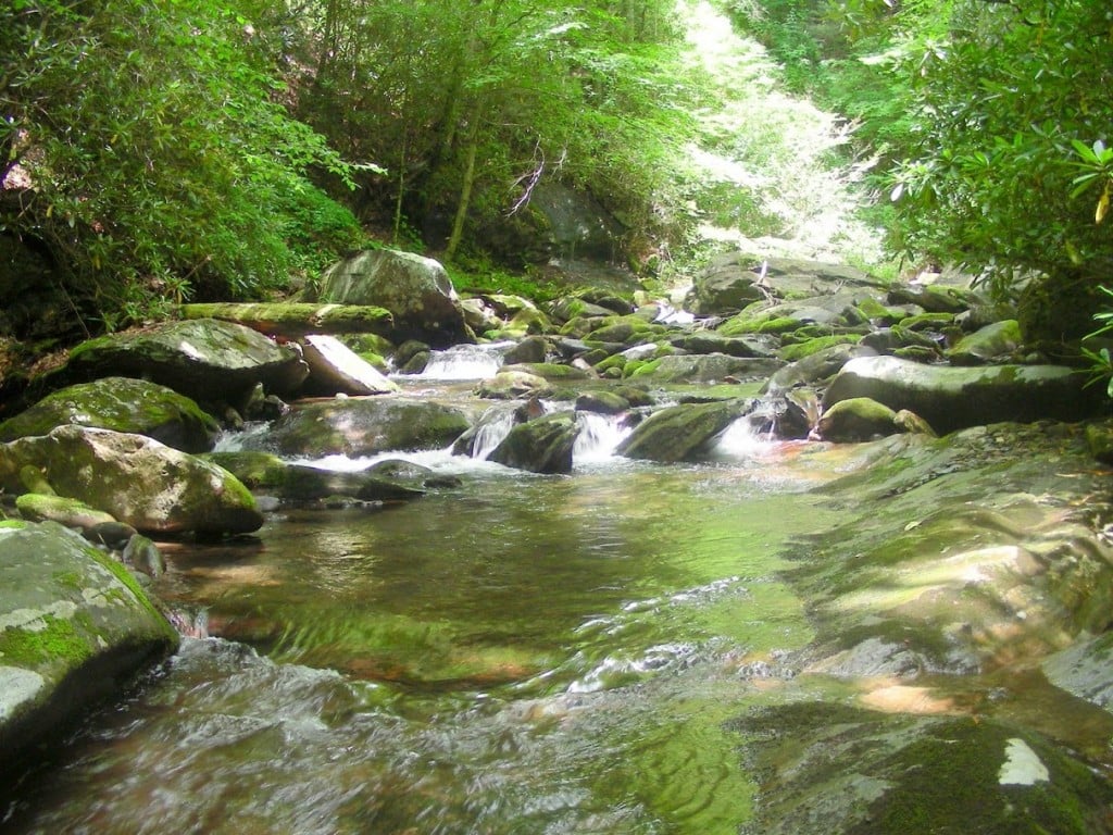 Some of the world’s best examples of Rich Cove, Hemlock, Northern Hardwoods, High Elevation Red Oak,Montane Hardwood, and Montane Cedar forest communities are found in the Craggies, A large designated Forest Service old growth patch stands within this area, and there are four verified sites containing 2,857 acres of old growth forest. Most of the old growth sites overlap with Natural Heritage Areas and other areas of significant biological habitat. There remains virgin forest in the Craggy Mountain area: researchers found a 300-year-old sugar maple in an area called Walker Cove and there are very ancient trees on Big Butt Ridge. Black bear, brook trout, and songbird populations thrive here as well, but perhaps most importantly for the Craggies is the nearby thriving organization, Friends of Big Ivy. This small dedicated organization of local farmers, families, landowners, teachers, artists, attorneys, local business leaders, clergy, hikers, equestrians, hunters, mountain bikers, anglers, and other outdoor enthusiasts are the perfect analogue for this diverse and unique landscape. They see the big picture for Big Ivy, supporting wilderness, maintaining trails, organizing cleanups, and protecting the area from commercial logging and resource extraction. All special places should be so lucky.
Of the 1.1 million acre Pisgah-Nantahala National Forest, only 64,000 acres are designated permanently as wilderness. The opportunity to add to this acreage is upon us, and were we to double this acreage with this new management plan, it would still leave well over eighty percent open to other management designations. If you care about these last wild places, you can get involved right now by following the forest planning process and weighing in when there are opportunities. Visit www.ncmountaintreasures.org to learn more.
[divider]Related Articles[/divider]


