What role do print maps play for outdoor adventurers in the digital age? Pisgah Map Company’s Pete Kennedy has a few ideas.
Pete Kennedy has never worried about his ability to make good maps.
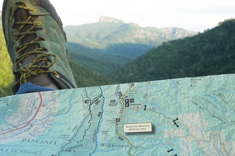
When the first batch of his first product arrived from the printer a decade ago, he could see that, of course, it covered the basics — contours, summits, and trails. It was also clear and uncluttered, or as Kennedy likes to say, “easy on the eyes.”
But more than that, he had packed his map with so many details gleaned from his hours in the woods and had taken so much care in his choice of colors, symbols and fonts, that the result was a sheet of tear- and water-resistant paper that could “speak to people,” said Kennedy, 48, owner and sole cartographer of Asheville’s Pisgah Map Co.
Still, Kennedy often deals with the existential question for his company that tends to come up whenever outdoor types gather: With the steady improvement in digital technology, do we actually need old-fashioned paper maps?
Based on the sales of his products and rave reviews from many of his customers, the answer seems to be “yes,” and for many of the expected reasons — the size, scope, reliability, and unbeatable look and feel of paper.
“For the first five or six years of doing this,” Kennedy said, “I kept asking myself, ‘Am I really doing this? Can I really build a business on paper maps?'”
First consider all that Kennedy is up against. Other than help from an occasional part-time employee and his distribution- and bookkeeping-guru wife, Haven, he works alone. From a bunker-like basement office in his North Asheville home, he not only faces off against national map companies but an ever-growing array of ever-improving digital mapping sites and smartphone apps.
Bulky guidebooks have all but disappeared from pack pockets on the Appalachian Trail, replaced by the Guthooks Guide app. Want to explore a less famous trail? Sites such as Gaia GPS, Avenza Systems, Trailforks and AllTrails offer access to vast collections of digital maps for a fraction of the cost of building a comparable paper-and-ink library.
Bob Levy, an avid hiker who has taught digital navigation classes for the Carolina Mountain Club, said that accessing AllTrails on his home computer gives him plenty of perspective for planning hikes.
“I can bring up a map that covers as much or as little of the area as I like. I can load trails and draw new trails,” said Levy, board chairman of the libertarian Cato Institute and a part-time Asheville resident. “I can even print a map that displays as little or as much as I want.”
He downloads digital trip maps on his phone, which frees him of dependence on cell phone service and allows access with little drain on his phone battery — two of the longstanding knocks against digital navigation. Supplementing AllTrails with the MotionX app during hikes, he gets real-time elevation-gain updates that no traditional map can provide. As a backup, he carries not a paper map, but a phone recharger.
“I find that everything I want to do, I can do on phone-based apps,” he said.
The Outdoor Industry Association, which tracks spending in many outdoor recreation sectors, has no information on the market share of digital mapping sites. But nobody, least of all Kennedy, doubts this is expanding, as is the number of hikers, cyclists, anglers, hunters and paddlers that, like Levy, are comfortable using them exclusively.
Kennedy has a fighting chance in this market because he loves getting out in the woods as much as his users do. He knows what they want in a map, knows the territory he puts on paper.
It’s what makes his maps better than his competitors’, said Bill Sanderson, a retired high school biology teacher who serves as Levy’s counterpart at the Mountain Club, leading courses on traditional map-and-compass navigation.
“That’s why I like his maps so much,” Sanderson said, referring to the touches that display Kennedy’s deep familiarity with the southern Appalachian Mountains. “He’s obviously someone who knows the area well enough to put those kind of details in.”
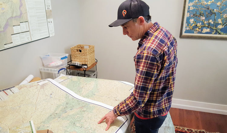
That Kennedy spends a lot of time in the woods was obvious in a recent visit to his home office. A collection of kayaks was stacked against a storage shed. When Kennedy answered the door, he showed off the fit, compact build of an avid mountain biker, trail runner and paddler.
There is a double irony in the actual production of maps. For all the talk about his own and his customer’s love of the outdoors, Kennedy said, each new release requires “hundreds of hours” cooped up inside, time he squeezes in between his duties as a full-time GIS mapping instructor at Asheville-Buncombe Technical Community College and father to five-year-old twin daughters. And products cast as a low-tech choice can only be produced using advanced mapping software.
In his office—cluttered with his collection of paper maps and illuminated by a television-sized computer monitor—he shows how this software allows him to build maps in layers. The template of contour lines, roads, and name-worthy natural landmarks is downloaded from the federal Geographic Names Information System, or GNIS. He imports the boundaries of state parks and national forests from other public sites and refines them with the detailed property lines available at county websites. He checks the accuracy of trails against hikers’ online trip reports that include routes tracked with global positioning system (GPS) devices.
When he learned mapping at Clemson University, where he received a master’s degree in forestry, such tasks often required writing code and hand-drawing lines. “Now it’s point and click,” he said.
Not so with the other part of the job, the part that taps into his knowledge of the woods and even occasionally requires him to visit them.
He is aware, for example, that the subject of his most popular map, Pisgah National Forest’s Pisgah Ranger District, includes regions that are short on outdoor attractions. So he focused on the part that is packed with them, allowing him to use a larger scale, and to reserve the flip side for a zoomed-in view of the district’s Bent Creek Area, a magnet for local mountain bikers. Knowing that a growing group of cyclists seeks out the district’s gravel roads, he marks precisely where the pavement ends, points that don’t show up on most other maps or on public sites. To make sure he has these just right, he heads out with a GPS device and “puts boots on the ground,” he said.
Sometimes he builds maps on contract. That first one, for example, was a map of Waterfalls of North Carolina, created to accompany Kevin Adams’ book of the same name. But his main product is a trail guide series that, so far, focuses on seven of the most popular natural areas of the southern Appalachians, including Pisgah Ranger District, Dupont State Forest and the Blue Wall of upstate South Carolina. He is in the final stages of producing a map of the French Broad Region, north of Asheville, which includes the names of the rapids on the Nolichucky River.
He chooses such details as a writer would—enough to tell the story, not so many that it bogs down the narrative. “It’s like doing a research project or a book,” he said.
And just as authors have accepted that digital formatting is a fact of life, Kennedy can’t afford to be a paper-and-ink purist. Though his main business is selling paper maps for $14 each at pisgahmapcompany.com and at stores throughout the region, he also publishes his products on Avenza.
Many of his fans use these versions in conjunction with the paper variety. But like most readers, they say you sometimes just can’t beat a hard copy.
Eric Wever, who with his wife, Erinna, owns Pisgah Productions, said Kennedy’s paper maps are integral for planning the races his company stages, including its signature event, the Pisgah Mountain Bike Adventure Race. To make this a test of both endurance and navigation skills, Wever doesn’t draw a specific route but picks five points on a map. He leaves it up to racers to figure out how to reach at least four of them before returning to the finish line. Creating a challenge that is super tough but not quite impossible requires a feel for the landscape that is best acquired through Kennedy’s maps, one of which he keeps posted “on the wall in front of my desk 365 days a year,” he said. “I just move those little dots around until I get what I want.”
Racers don’t learn of these waypoints until they arrive at the starting line, where they huddle around a piece of required equipment for the race, a Pisgah Map Co. map.
“They’ll put tiny rocks on all those places I’ve had on my map for a year, saying ‘How the hell are we going to get there?’” Wever said.
Levy is strictly a day hiker and acknowledges that he might use a paper map if he ever decides to take on an extended trip. Greg Hardy’s business and passion, bikepacking, is all about extended trips. He’s the owner of Rockgeist, near Asheville, which makes bags and other gear for his sport. With a doctorate in materials science, he’s plenty tech-savvy, but wouldn’t think of embarking on one of his adventures without the assurance of a paper map—preferably Kennedy’s, but other brands when cycling in regions that Pisgah Map Co. doesn’t cover. While navigating the dizzying climbs and descents of the 500-mile Colorado Trail, for example, he reached the potentially disastrous point where he was stopped short by a fire closure.
“It’s brutal,” he said, of the trail. “It covers the kind of terrain where you don’t want to backtrack and the reroute was way off the preloaded map on my Garmin. Fortunately I had a paper map so I could use that to get back on track.”
“I love (Kennedy’s) maps,” said Katie Scheip, a ranger at North Carolina’s Chimney Rock State Park and a former student of Kennedy’s at A-B Tech. Serving on search-and-rescue teams on the job and as a volunteer with the Henderson County Rescue Squad has exposed her to the value of Kennedy’s paper maps, which both agencies use to coordinate their efforts. Her work has also given her a close-up view of the hazards of thoughtless dependence on navigating by smart phones.
“I see that with a lot with the people we end up looking for,” she said. “Usually how it happens is, somebody goes into the woods and they think they know where they are going and their battery starts to die or they don’t have a good cell phone signal. So when their phone is just about to die, they call 911.”
Reliance on small digital maps also carries a more subtle danger for outdoor enthusiasts, Sanderson said, a failure to appreciate their place in the broader landscape. Like drivers who automatically punch their destinations into Google Maps, hikers who rely on apps can get from one point to another without ever learning about their surroundings. It’s a practice that may be fine for meeting friends at a bar or showing up at work appointments, but it defeats the whole purpose of a sport like hiking.
“Maybe it’s tactile, maybe it’s the broad view. But all of those things just make (paper maps) so much superior, at least for learning. If someone who has never had the experience of using a map or compass just picks up a phone with GPS and thinks they can navigate, I don’t think they ever really understand the lay of the land.”
They can get to the end of the book, Kennedy might say, but never understand the story.


