Everything was wet.
Water pooled on the tent floor. Flecks of leaves and dirt clung to the tent wall and exposed skin. We peeled off layers of drenched clothing as we sat on soggy gear. My partner, Seth, reached into the depths of his pack and pulled out a pair of wool socks with a flourish. The last dry item. We each took one and used it to dry ourselves off, falling asleep to thunder and the roar of pouring rain, dreaming of sunshine and dry clothing.
The relatively unknown, 360-mile Southern Appalachian Loop Trail (SALT) incorporates sections of the Appalachian, Bartram, Foothills, Mountains to Sea, and Art Loeb Trails, traversing North Carolina, South Carolina, Tennessee, and Georgia in the process. The SALT seemed like the perfect summer loop – a medley of classic trails with relatively simple logistics. Unfortunately, the timing of our thru-hike of the SALT would have us crossing paths with Tropical Storm Alberto as it tore up the East Coast earlier this summer.
The first miles on the Appalachian Trail passed rather uneventfully once we climbed out of Nantahala Gorge, as I watched vibrant greenery pass beneath my hooded poncho. We were fighting a losing battle on the very first day to keep our gear dry in the near constant downpour.
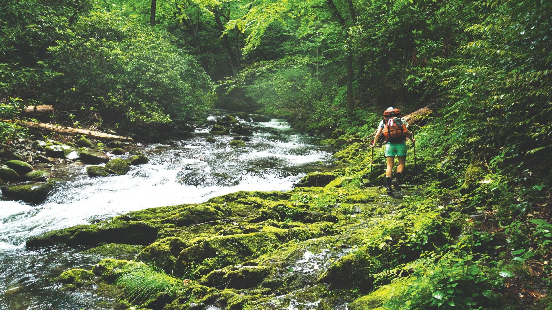
We soon connected with the Bartram Trail and, after steeply plunging up and down for the remainder of the day, found a campsite nestled into the jungle that is Nantahala National Forest. Taking advantage of a break in the rain to cook dinner outside of the tent, we lounged on sleeping pads, allowing soggy feet to de-wrinkle. But just as the water was boiling, a wall of rain came out of nowhere, drenching us and our tortellini.
The next day, we planned an earlier-than-expected stop in Clayton, Ga. Mexican food and a forty-ounce beer proved to be a much-needed morale boost.
We embarked on our last day on the Bartram before joining the Foothills Trail, which rolls through several steep gorges. Indulging in a ramen lunch break on a rock beside Lake Jocassee, we contemplated swimming. I asked Seth if there were any snakes.
“Not likely,” he replied. We eased into the water.
“Except for that black snake right there…which is…it’s a water moccasin,” he calmly added. I exited the water with a frown and stood dripping on the middle of the rock.
We waved goodbye to the Foothills Trail atop Sassafras Mountain, the highest point in South Carolina, and, armed only with a picture of a map that we took at the Sassafras trailhead, we headed into the unknown.
For the rest of the afternoon we hiked along a gravel road through a no man’s land between Sassafras and Raven Cliffs State Park. There were no signs that anyone had used the road recently, no signs of humans, and also no signs. Without cell signal, we were flying blind. Miraculously, we connected with Raven Cliffs. We passed into Jones Gap State Park uneventfully, and we only briefly found ourselves lost before road walking our way into Brevard.
Fortified by burgers and root beer floats, and bubbling with excitement for the remainder of the SALT, we left Brevard by way of the Bracken Mountain Trail. Soon we linked up with the famous Art Loeb, which I have been fortunate enough to hike many times over the last ten years. I was anticipating the steady climb up Pilot Mountain and the glorious spruce aroma atop the Balsam ridgeline, and the Art Loeb did not disappoint.
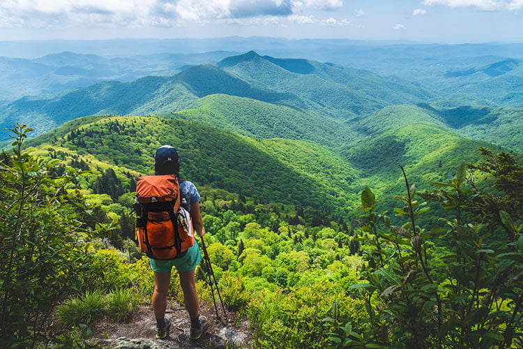
Just after crossing the Blue Ridge Parkway, we began following the Mountains to Sea Trail, which would take us all the way to Clingmans Dome in the Smokies. After twisting through the Middle Prong Wilderness, the trail follows an old fire road that was covered in knee-high stinging nettles. To distract ourselves from the itching, we took solace in beautiful greenery and the occasional view.
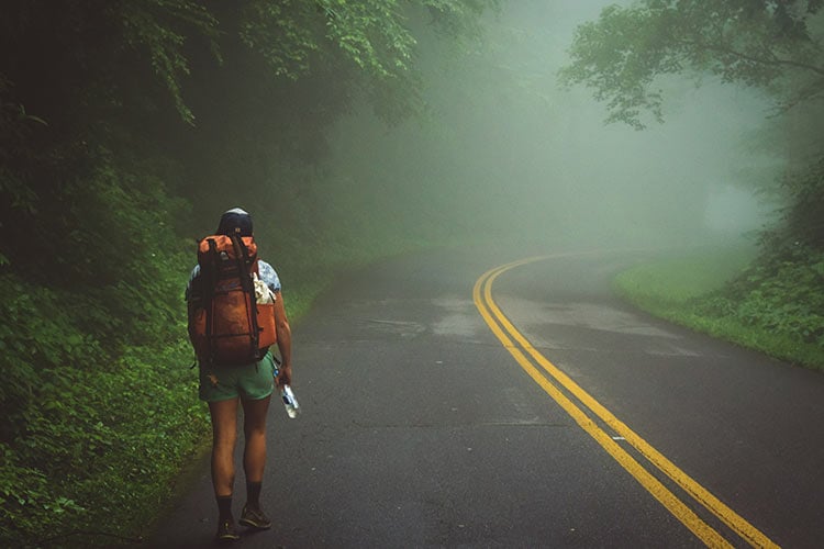
After catching sight of a cloud-inversion from Waterrock Knob, we were disappointed to discover that the next section of the SALT would have us traveling on the Parkway itself. We plodded along in the heat, stepping aside for passing cars and wishing we were in the cool, lush forest instead.
The next morning, we entered Great Smoky Mountains National Park, and our deadened road legs were instantly refreshed by the magic of the place. Each visit to the Smokies, I marvel at the biodiversity of the park. We hiked past purple wildflowers, delicate ferns and mosses, cold mountain streams, and Narnia-like evergreen trees.
We enjoyed two unforgettable nights in the Smokies as we worked our way up to Clingmans Dome. The second night, we were visited by three wild boars. Each had tusks and weighed at least 300 pounds. They stared at us for a few seconds before scampering off into the woods.
We followed the Appalachian Trail for 48 more miles, walking down to Fontana Dam, up to Cheoah Bald, and then finally down to the NOC for pizza. After an 18 day, 360 mile walk in the woods, we were feeling quite celebratory indeed.
The SALT tested us physically. There was a good bit of road walking, and not all of the trail sections were flowing singletrack. But for local hiking enthusiasts, the SALT is a quintessential sampling of Southern Appalachia.
By The Numbers
Seth and Leah’s SALT Trail Hike
Days: 18
Miles: 360 miles
Average mileage per day: 20 miles
Highest mileage day: 26 miles
Average amount of sleep per night: 8-9 hours
Shoes worn: Nike Wildhorse 4s (trail runners)
Favorite hiking dinner: Pesto tortellini
Favorite hiking snack: Sour Cream and Chives crackers
Calories consumed/day on trail: 3000
Calories consumed/day in town: 4000
Other hikers we saw during four days on Bartram Trail: 1
Showers taken: 2
Trails hiked: AT, Bartram, Southern Foothills, Palmetto, Mountains to Sea, Bracken Mountain Trail, Art Loeb Trail
States covered: NC, SC, TN, GA
Longest stretch without visiting a town: 7 days


