6 ICONIC WATERWAYS—and the people fighting to protect them
In 2018, we commemorate 50 years of the Wild & Scenic Rivers Act. It’s a good time to celebrate the rivers that sustain us all—especially six iconic rivers in our Blue Ridge backyard.
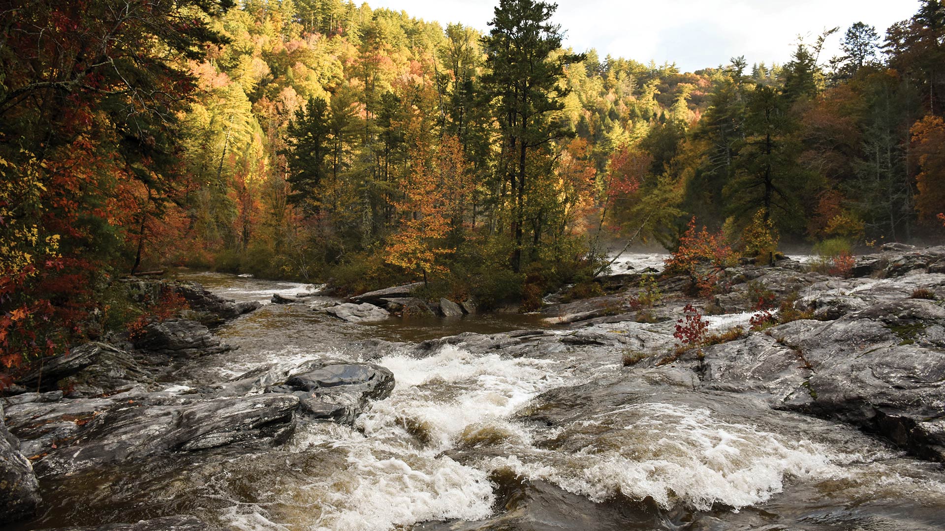
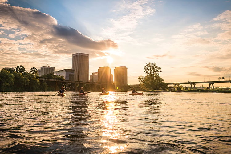
Chattooga River (Featured)
North Carolina – Georgia – South Carolina
Practically equidistant from the major metropolitan areas of Atlanta, Ga., and Greenville, S.C., the Chattooga River has long provided a recreational oasis for Southeasterners looking to escape the grind. It’s one of the few remaining free-flowing rivers in the region, winding unimpeded by dams for 56.9 miles from the base of Whitesides Mountain in western North Carolina to Tugaloo Lake at the confluence of the Tallulah River.
Once home to the Cherokee, Chattooga, or Tsatugi, has been interpreted as, “he drank by sips,” or, “he has crossed the stream and come out upon the other side,” according to New Georgia Encyclopedia. But take a look back through the Chattooga’s history and it feels like it was the river, not man, that entered turbulent times and came out on the other side safely.
Logged almost entirely during the late 19th and early 20th centuries, the nearly 190,000-acre Chattooga watershed is today one of the most critical refugia for at-risk species migrating due to climate change. The U.S. Forest Service manages 70% of the watershed, with over 120,000 acres residing in three different national forests—the Nantahala in North Carolina, the Chattahoochee in Georgia, and the Sumter in South Carolina.
Throughout the early to mid 20th century, eight dams were proposed on the Chattooga but they never came to fruition, thanks in large part to the efforts of the Chattooga Conservancy. In 1971, a Congress-appointed task force released its “Wild and Scenic Report” on the Chattooga, recommending the river for Wild and Scenic designation. Three years later in 1974, the Chattooga officially became one of the first Wild and Scenic rivers in the country.
“I used to be a river guide before I got into the conservation business,” says Chattooga Conservancy Executive Director Nicole Hayler. “A lot of people come and go through the river guiding community and guide all over the world in places like New Zealand and Nepal, all over the place, and so many come back to the Chattooga and say it’s their favorite river. I can’t put my finger on it as to why it’s so alluring. It just is. It really takes you back into the feeling of being in a wilderness.”
Experience the Chattooga Section IV of the Chattooga is a classic whitewater run in the Southeast. Kayakers should have solid class IV paddling skills to run the river comfortably, but for those who are new to the world of whitewater, there are plenty of outfitters like the Nantahala Outdoor Center that offer rafting trips (starting at $110 per head). Anglers can fish for stocked trout at Burrells Ford bridge or head north towards Ellicott Rock to try landing some wild brown trout.
Scout for species
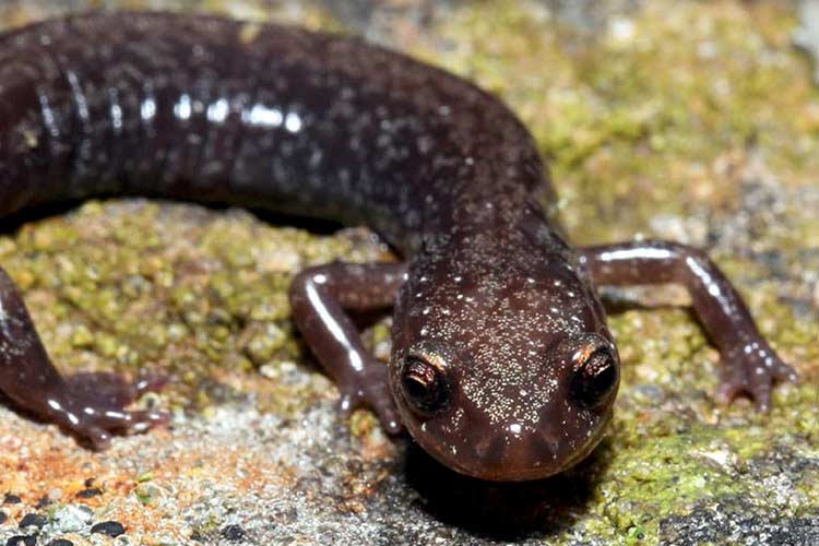
The Chattooga crayfish is specific to the Chattooga watershed. It’s about 3.5 inches in length with dull green claws and a light amber body. Plethodontid salamanders, or lungless salamanders, are also commonly found in the watershed. Because these salamanders breathe through their skin and depend on a damp environment to survive, the Chattooga watershed, considered a temperate rainforest, makes for the ideal habitat.
Know the threats
Southside Project timber sale in the Cashiers-Highlands area, which is the site for the headwaters of the Chattooga; city of Clayton raw sewage contamination in Stekoa Creek, a majorly polluted tributary to the Chattooga.
Lend a hand
Become a member of the Chattooga Conservancy or volunteer for a river cleanup. The organization hosts monthly cleanups through September.
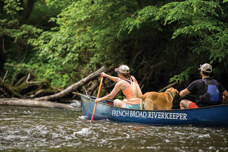
French Broad River
North Carolina
Though the Cherokee name for the French Broad, Tah-kee-os-tee, means “racing waters,” there was a time when western North Carolina’s beloved broad was considered “too thick to drink but too thin to plow.” Throughout the late 19th and early 20th centuries, industrialization slowly overtook the banks of the French Broad, so that by the 1950s, the river was considered more of a toxic dumping ground and less as a natural resource.
After the passage of the Clean Water Act in 1972, all of that began to change. Today, over one million people rely on the 4,000-square-mile watershed for their drinking water, and that doesn’t include the explosive population in Knoxville, which draws its drinking water from the Tennessee River, formed by none other than the French Broad and Holston Rivers.
Despite point source pollution like unlined coal ash ponds on Duke Energy property and the recent fuel storage tank leak that resulted in 1,000 gallons of petroleum oozing into the French Broad, the river’s health is better than it’s ever been. The river is now home to more than 100 species of fish. Over 50% of the watershed is forested, with much of that buffer protected by the Great Smoky Mountains National Park and Blue Ridge Parkway.
The revitalization of the French Broad has simultaneously restored the region’s economy, too. Communities like Marshall and Hot Springs, not to mention the city of Asheville, are sustainably capitalizing on the river as an eco-tourism attraction. Riverfront space, once the cheapest lots in town, is now prime real estate. Breweries, outfitters, and other outdoor industry business are purposefully relocating to have better access to the river.
“It’s important to remember how we got to this point,” says French Broad Riverkeeper Hartwell Carson. “It wasn’t an accident that thousands of people now float the river on a Saturday. It was the passage of the Clean Water Act and the implementation of that law that brought the river back from the brink of extinction, but it doesn’t mean there’s a guarantee it’ll stay clean in the future. We have to continue that hard work to keep the French Broad pristine.”
Experience the French Broad
The most accessible way to see the French Broad is to flow the section of river from Hominy Creek to the Salvage Station in Asheville. You can get away with a craft as minimal as a Walmart inner tube if that’s all you have. Whitewater boaters with class III skills should paddle section nine of the French Broad, which flows naturally for much of the year. Flatwater paddlers will enjoy the French Broad River Trail, a 140-mile blueway that offers multiple access points, campgrounds, and paddling services for overnighters of varying lengths.
Scout for species
The Appalachian elktoe is an endangered species of mussel that resides on the Mills and Little Rivers in the upper reaches of the French Broad watershed. The eastern spiny softshell turtle is considered a North Carolina species of concern and likes to burrow in the soft bottoms of the French Broad.
Know the threats
Rapid and thoughtless development; point source pollution from leaky coal ash ponds; radioactivity from Duke Energy coal plants
Lend a hand
Participate in the Riverkeeper Beer Series, an eight-part river cleanup and special beer release summer series; Blue Ridge Outdoors and MountainTrue Litter Floatilla on September 20th
Watauga River
North Carolina – Tennessee
Given that the Watauga River basin is one of the smallest in the state of North Carolina (only 205 square miles total), the river has an almost larger-than-life reputation as being one of the best fishing and paddling destinations in the country. Trout fishing, in particular, has been a huge boon to the local economy. A 2017 study released by Responsive Management and Southwick Associates for the North Carolina Wildlife Resources Commission found that trout fishing on rivers like the Watauga (which has 171 miles of state-designated trout waters) contributed $383 million to western North Carolina’s economy.
Contained entirely within North Carolina’s High Country, over two-thirds of the Watauga watershed is forested and includes portions of Grandfather Mountain State Park, Pisgah National Forest, the Blue Ridge Parkway, and Elk Knob Game Land. Historically, the river was mostly harnessed for power. Four dams provided hydroelectric power for the numerous saw and gristmills that once ran the lengths of the Watauga’s banks.
Today, it’s farmers, not mills, which depend on the river. About 10% of the Watauga watershed is covered in row-crop farms, Christmas tree farms, and livestock operations, all of which have caused sedimentation and erosion issues as of late. Yet it was a single tannery that operated near Valle Crucis in the 20th century which, anecdotally at least, seems to have caused the most lasting damage to the native species of the Watauga.
More than the agricultural impacts and even the gasoline seepage that has happened multiple times in the past year alone, Watauga Riverkeeper Andy Hill is worried about steep-slope development. Because of the mountainous topography of Avery and Watauga counties, Hill says it’s imperative that developers do more in the way of riparian zone protection, which will, in turn, protect habitat for trout and shiners and salamanders, which need cool clean water to survive.
“Even though the water quality now is excellent, we’ve really seen the local population jump in the last five to 10 years,” says Hill. “People are realizing Boone and the High Country, in general, is a wonderful place to be, but we need to do more to address that explosive development. Being as isolated and well-protected as it is, the Watauga has been able to remain clean, clear, and cold while other rivers have become impaired, and we need to work to keep it that way.”
Experience the Watauga
Anglers can cast a line for brook, brown and rainbow trout at the 321 river access point or at Valle Crucis Community Park. Further downstream, there’s plenty of smallmouth bass fishing to be had, too. Class IV+ paddlers would be remiss to not kayak the Watauga when it’s running. This boulder-strewn river can be a fun, creeky run one day and a high-volume wave train the next.
Scout for species
The banded sculpin is a winter spawner that resides in the Watauga river bottom’s rocks and slabs. The aptly named tangerine darter is a flashy, brilliant shade of orange and is the largest darter in the state, reaching upwards of seven inches in length.
Know the threats
Habitat loss due to steep slope development; agricultural runoff; diminished riparian zones; aquatic nuisance species such as gill lice and whirling disease
Lend a hand
Become a member at MountainTrue.org.
Clinch River
Virginia – Tennessee
Located in the heart of Virginia’s coal country, the Clinch River arguably supports more threatened and endangered aquatic species than any other river in North America. It begins in Tazewell County and flows freely for nearly 200 miles until it reaches Norris Lake in Tennessee. The combined Clinch-Powell five-county watershed has historically been responsible for 40% of Virginia’s coal production, with the remaining 60% conducted in two adjacent counties.
Acid mine drainage and heavy sediment continue to contaminate the river. Combined with the negative effects of agriculture, the other primary economic activity in the region accounting for one-third of the area’s land use, this incredible hotbed for diversity is one of the most at-risk rivers in our country.
But, there is hope. The Clinch River Valley Initiative and The Nature Conservancy’s Clinch Valley Program have joined forces to defend the Clinch, and are recently underway with the creation of the Clinch River State Park. When complete, the state park will provide 600 acres of canoeing, hiking, and camping for Southwest Virginia, simultaneously creating a protective barrier for a river that is home to more than 40 species of freshwater mussels, 20 of which are federally listed endangered species.
According to Chmura Analytics, this state park could generate $3.58 million annually and create 31 local jobs in the first five years of existence. For a region like Southwest Virginia that is struggling to redefine itself in the wake of the coal industry’s decline, the Clinch River is a much-needed lifeline.
“Southwest Virginia, like the rest of the Central Appalachian coalfields, faces profound economic and social challenges,” says The Nature Conservancy Clinch Valley Program Director Brad Kreps. “Right now, we are going through a significant transition as the coal mining industry declines and the region seeks ways to diversify, strengthen, and renew local economies. Assets like a new Clinch River State Park will help Southwest Virginia attract visitors interested in recreation but also new businesses that place a high value on access to nature and quality of life.”
Experience the Clinch
Depending on water levels, the Clinch is mostly a flatwater experience, which makes it a wonderful river to float on a hot summer day. Clinch River Adventures in the river town of St. Paul, Va., offers shuttle services and rentals (from $12). Fly fishermen can float down past Norris Dam in Tennessee, where the Clinch River has 13 miles of tailwaters stocked with rainbow and brown trout.
Scout for species
Feared that it had gone extinct in 1969, the yellowfin madtom is still swimming in the warm waters of the Clinch River. Even more rare than the madtom are the 20 endangered species of mussels like the rough rabbitsfoot, fluted kidneyshell, and cumberlandian combshell. For many of these mussels, the Clinch River population is the last holdout.
Know the threats
Residual contamination from abandoned mined lands; mountaintop removal and valley fills; agriculture-related sedimentation and erosion; stormwater runoff
Lend a hand
Visit Southwest Virginia and support the river with your dollar; donate to The Nature Conservancy or the Clinch River Valley Initiative.
James River
Virginia
It would not be an overstatement to say that the history of our nation literally unfolded along the banks of the James River. From the settlement of Jamestown to the Civil War “battle of the ironclads,” “America’s Founding River” has witnessed some of the most pivotal points in our fledgling country’s saga. Long before Captain John Smith pulled his boat to shore, Powhatan and Monacan Indians had been utilizing the James as a source for sustenance, travel, trade, and defense. The river largely continued to fulfill those roles as Europeans made their way up the watershed.
From its beginnings at the confluence of the Jackson and Cowpasture Rivers, the James flows for 340 miles to the Chesapeake Bay. That makes it Virginia’s largest river, covering one-fourth of the entire state and sustaining one-third of the state’s population, many of whom depend on the river directly for drinking water.
Because the river flows through major urban centers like Richmond and Hampton Roads, the river has not escaped the threats of industrialization and pollution. Just three years after the Clean Water Act was passed, the harmful pesticide Keypone was discovered in the James in dangerous quantities. The river quickly rose to the top as one of the most polluted rivers in the nation, and a subsequent 13-year ban on commercial fishing killed the area’s fishing industry.
The James River Association (JRA) was founded in 1976 as a result of the Keypone dumping and has been working to restore the river’s health ever since. To date, the James is cleaner than it has been at any point in the past 100 years, but there remain concerns over the river’s proximity to coal ash ponds at three major facilities in the watershed. According to JRA, there are 1,100 toxic storage sites, up to 5 billion gallons of coal ash, and millions of gallons of crude oil traveling along the James each week.
Fortunately for the James, because it is such a large and vital river, it has a lot of people who care about conserving it. Less than 40 years ago, no one would have ever imagined that bald eagles or Atlantic sturgeon would call the James home again, but today, both of these species are thriving, even in downtown Richmond.
“Today especially, a lot of these people depend on the river. It’s their livelihood,” says James Riverkeeper Jamie Brunkow. “If we don’t have a healthy river, that’s affecting their ability to get drinking water and downstream, it’s affecting industry and tourism. The river is that critical nexus to keep everything connected.”
Experience the James
Begin in Botetourt County and float through the Blue Ridge Mountains along the Upper James River Water Trail. The pristine beauty (and ample smallmouth bass fishing) here is absolutely unparalleled. Whitewater kayakers will appreciate the unique urban setting of the class III+ Lower James. If you’re not a paddler, you can still bike along its shores through the James River Park System or ride in a raft with an outfitter like RVA Paddlesports (starting from $60 per person). Though technically a tributary of the James, the Chickahominy is worth a trip all to itself. There’s a water trail in the works here (put in at Grapevine Bridge), which allows paddlers to float 100 miles of tupelo and cypress-lined blackwater back to the James.
Scout for species
The massive Atlantic sturgeon call the James home just downstream of Richmond. These prehistoric looking creatures can be up to 14 feet in length and weigh 800 pounds. The James is also home to the James spinymussel, an endangered species of freshwater mussel that sprouts short spines on each valve.
Know the threats
Agricultural runoff; urban development; wastewater discharge; coal ash.
Lend a hand
Participate in JRA River Hero Home pledge system; become a member of JRA; volunteer for water testing programs
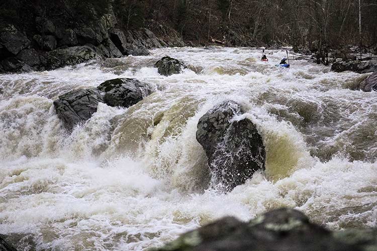
Cheat River
West Virginia
No one knows exactly where the name of the Cheat originated. The Delaware Indians’ name for the river was Ach-sin-ha-nac, which loosely meant “stony river.” Later, settlers claimed the proliferation of cheatgrass along the river’s banks gave it its name. Regardless of its origins, many felt the river was appropriately named, albeit doomed, especially after the flood of 1985, which devastated many of the watershed’s dying coal towns like Rowlesburg, Albright, and Parsons, killing dozens and “cheating” many out of life as they knew it.
Things didn’t improve after that. In 1994, an illegally sealed underground coal mine blew out and poured contaminated mine water into Muddy Creek, a major tributary to the Cheat. A year later, another blowout occurred. The river ran orange for 16 miles downstream, killing everything in its flow. The pH of Cheat Lake dropped to 4.5. American Rivers listed the Cheat as one of the top 10 most endangered rivers in the country, and the river’s burgeoning rafting industry collapsed.
But, you know the saying—it always gets worse before it gets better. The mine blowouts galvanized an impassioned community of river stewards and stakeholders, who then formed the Friends of the Cheat (FOC). In the last 20 years, FOC has been at the forefront of implementing 15 acid mine drainage remediation sites on the river. That work is far from over, but the mainstem of the Cheat River has been restored, so much so that sensitive species like walleye are well and thriving in the Canyon.
“What makes the Cheat especially important to a state like West Virginia is the hope,” says FOC Executive Director Amanda Pitzer. “It’s the reality that in someone’s lifetime, this river was dead and people came together and made a difference and changed it. We hope that other people see the work that FOC has done and not just accept that things are broken or that rivers are polluted because things can get better.”
Experience the Cheat
The Cheat’s rafting industry is also well and thriving and the Canyon, along with some of the river’s major tributaries like the Big Sandy, provide some of the best class IV boating in the Mid-Atlantic. Cheat River Outfitters in Albright, W.Va., offers rafting trips down the big-wave Canyon starting at $85 per person. Shavers Fork, another tributary to the Cheat, is a little-known trout fishing gem while the mainstem of the Cheat has flourishing numbers of smallmouth bass and pike. Though it doesn’t follow the banks of the Cheat, the northernmost 28 miles of the Allegheny Trail is a little-traveled backcountry hiking trail that offers views of the river from above.
Scout for species
You can thank the flat-spired three-tooth snail for preserving the Cheat Canyon. This little snail only lives in the Cheat Canyon and resides in the cracks and crevices of this boulder-choked river. The Cheat Mountain Salamander is also unique to the Cheat, specifically its headwaters, and is a small four-inch dark brown amphibian with shiny gold coloring along its back.
Know the threats
Defunding of programs like the Abandoned Mine Land Reclamation Program that support acid mine drainage remediation; fracking proposals on major tributaries to the Cheat; gas pipelines; climate change impacts to water flow
Lend a hand
Boat with your wallet and support local establishments; become a member of FOC (cheat.org); come to Cheat Fest in the spring


